

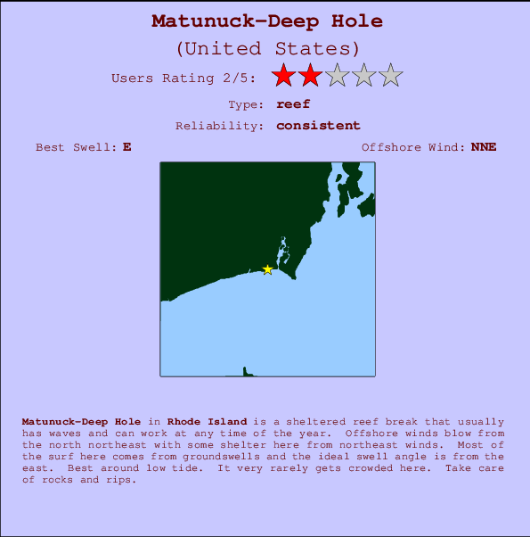
Matunuck-Deep Hole Surf Guide
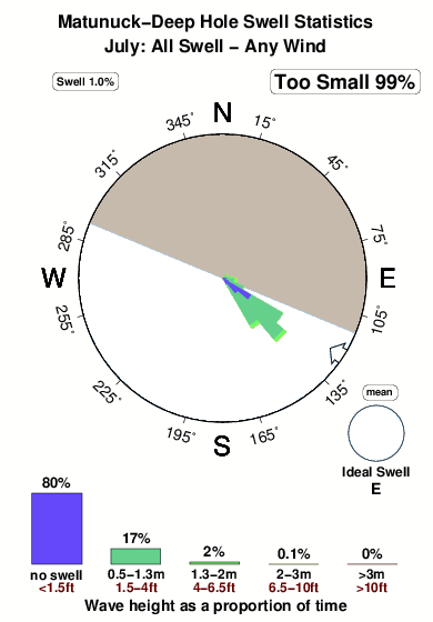
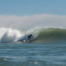
Matanuck-Deep Hole in Rhode Island is a sheltered reef break that has consistent surf and can work at any time of the year. The best wind direction is from the north northeast with some shelter here from northeast winds. Waves just as likely from local windswells as from distant groundswells and the best swell direction is from the east. A reef breaks left. Best around low tide. It very rarely gets crowded here. Beware of rocks and rips.
Matunuck-Deep Hole Spot Info
| Type: | Rating: | Reliability: | Todays Sea Temp*: |
|---|---|---|---|
| consistent | 20.2°C*ocean temperature recorded from satellite |
Surfing Matunuck-Deep Hole:
The best conditions reported for surf at Matunuck-Deep Hole occur when a East swell combines with an offshore wind direction from the North-northeast.

Energía de Olas (poder): 12 horas


Matunuck-Deep Hole Surf:
Tuesday, 14 July 2026, 06:06 Local time| martes 14 | ||||
| 5AM | 8AM | 11AM | 2PM | |
| Wave (m) | ||||
| Período (s) | 5 | 5 | 5 | 5 |
| Viento (km/h) | ||||
| Estado del Viento | cross- on |
cross- on |
cross- on |
cross- on |
- /breaks/Matanuck_Deep-Hole/forecasts/latest
Matunuck-Deep Hole Surf Guide
Matanuck-Deep Hole in Rhode Island is a sheltered reef break that has consistent surf and can work at any time of the year. The best wind direction is from the north northeast with some shelter here from northeast winds. Waves just as likely from local windswells as from distant groundswells and the best swell direction is from the east. A reef breaks left. Best around low tide. It very rarely gets crowded here. Beware of rocks and rips.
Matunuck-Deep Hole Spot Info
Type: Rating: Reliability: Todays Sea Temp*:  Reef
Reef 2
2consistent 20.2°C*ocean temperature recorded from satelliteSurfing Matunuck-Deep Hole:
The best conditions reported for surf at Matunuck-Deep Hole occur when a East swell combines with an offshore wind direction from the North-northeast.
Energía de Olas (poder): 12 horas
Usa la barra de navegación de arriba para ver la temperatura del mar en Matunuck-Deep Hole, fotografías Matunuck-Deep Hole, previsiones detalladas de olas para Matunuck-Deep Hole, vientos y previsión del tiempo, webcams para Matunuck-Deep Hole, viento actual desde estaciones meteorológicas en Rhode Island y predicciones de marea para Matunuck-Deep Hole. Las mapas de olas para United States enseñarán un mapa grande de United States y los mares que rodean. Los mapas de olas pueden ser animadas para mostrar diferentes componentes de olas, la altura de ola, la energía de ola, el período, junto con previsiones de viento y del tiempo. Previsiones actuales del tiempo y del estado del mar provienen de boyas marinas de United States, del barcos que transitan en la zona y de estaciones meteorológicas costeras. Cada página de previsiones tiene un Busca-Olas Regional y Global para localizar las mejores condiciones para surfear en el área de Matunuck-Deep Hole.
Matunuck-Deep Hole Surf:
Tuesday, 14 July 2026, 06:06 Local timemartes 14 5AM 8AM 11AM 2PM Wave (m) Período (s) 5 5 5 5 Viento (km/h) Estado del Viento cross-
oncross-
oncross-
oncross-
on- /breaks/Matanuck_Deep-Hole/forecasts/latest
- /breaks/Matanuck_Deep-Hole/forecasts/latest/six_day
Matunuck-Deep Hole Surf Guide
Matanuck-Deep Hole in Rhode Island is a sheltered reef break that has consistent surf and can work at any time of the year. The best wind direction is from the north northeast with some shelter here from northeast winds. Waves just as likely from local windswells as from distant groundswells and the best swell direction is from the east. A reef breaks left. Best around low tide. It very rarely gets crowded here. Beware of rocks and rips.
Matunuck-Deep Hole Spot Info
Type: Rating: Reliability: Todays Sea Temp*: Reef2consistent 20.2°C*ocean temperature recorded from satelliteSurfing Matunuck-Deep Hole:
The best conditions reported for surf at Matunuck-Deep Hole occur when a East swell combines with an offshore wind direction from the North-northeast.
Energía de Olas (poder): 12 horas
Usa la barra de navegación de arriba para ver la temperatura del mar en Matunuck-Deep Hole, fotografías Matunuck-Deep Hole, previsiones detalladas de olas para Matunuck-Deep Hole, vientos y previsión del tiempo, webcams para Matunuck-Deep Hole, viento actual desde estaciones meteorológicas en Rhode Island y predicciones de marea para Matunuck-Deep Hole. Las mapas de olas para United States enseñarán un mapa grande de United States y los mares que rodean. Los mapas de olas pueden ser animadas para mostrar diferentes componentes de olas, la altura de ola, la energía de ola, el período, junto con previsiones de viento y del tiempo. Previsiones actuales del tiempo y del estado del mar provienen de boyas marinas de United States, del barcos que transitan en la zona y de estaciones meteorológicas costeras. Cada página de previsiones tiene un Busca-Olas Regional y Global para localizar las mejores condiciones para surfear en el área de Matunuck-Deep Hole.
Matunuck-Deep Hole Surf:
Tuesday, 14 July 2026, 06:06 Local timemartes 14 5AM 8AM 11AM 2PM Wave (m) Período (s) 5 5 5 5 Viento (km/h) Estado del Viento cross-
oncross-
oncross-
oncross-
on- /breaks/Matanuck_Deep-Hole/forecasts/latest
Matunuck-Deep Hole Surf Guide
Matanuck-Deep Hole in Rhode Island is a sheltered reef break that has consistent surf and can work at any time of the year. The best wind direction is from the north northeast with some shelter here from northeast winds. Waves just as likely from local windswells as from distant groundswells and the best swell direction is from the east. A reef breaks left. Best around low tide. It very rarely gets crowded here. Beware of rocks and rips.
Matunuck-Deep Hole Spot Info
Type: Rating: Reliability: Todays Sea Temp*: Reef2consistent 20.2°C*ocean temperature recorded from satelliteSurfing Matunuck-Deep Hole:
The best conditions reported for surf at Matunuck-Deep Hole occur when a East swell combines with an offshore wind direction from the North-northeast.
Energía de Olas (poder): 12 horas
Usa la barra de navegación de arriba para ver la temperatura del mar en Matunuck-Deep Hole, fotografías Matunuck-Deep Hole, previsiones detalladas de olas para Matunuck-Deep Hole, vientos y previsión del tiempo, webcams para Matunuck-Deep Hole, viento actual desde estaciones meteorológicas en Rhode Island y predicciones de marea para Matunuck-Deep Hole. Las mapas de olas para United States enseñarán un mapa grande de United States y los mares que rodean. Los mapas de olas pueden ser animadas para mostrar diferentes componentes de olas, la altura de ola, la energía de ola, el período, junto con previsiones de viento y del tiempo. Previsiones actuales del tiempo y del estado del mar provienen de boyas marinas de United States, del barcos que transitan en la zona y de estaciones meteorológicas costeras. Cada página de previsiones tiene un Busca-Olas Regional y Global para localizar las mejores condiciones para surfear en el área de Matunuck-Deep Hole.
Matunuck-Deep Hole Surf:
Tuesday, 14 July 2026, 06:06 Local timemartes 14 5AM 8AM 11AM 2PM Wave (m) Período (s) 5 5 5 5 Viento (km/h) Estado del Viento cross-
oncross-
oncross-
oncross-
onTide Times:
Para Moonstone Beach, Rhode Island, a %{dist} %{km} de %{location}.
PROXIMA ES A LAS (hora local) quedan marea alta marea baja Matunuck-Deep Hole Tide Times and Tide Chart
Live Weather:
At BUOY-NWPR1, 22 km from Matunuck-Deep Hole.
light winds from the SW
(km/h)Air temperature
21.8°CCurrent weather near Matunuck-Deep Hole
Buoy Data:
At Block Island, RI, 35 miles from Matunuck-Deep Hole.
12AM 1AM 2AM 3AM Antigüedad de datos 4 hr 3 hr 2 hr 1 hr Altura de Olas (m) 

Período Dominante (s) 5 5 5 5 Overall Matunuck-Deep Hole Surf Consistency and Wind Distribution in julio


Wind stats for Matunuck-Deep Hole: see the variation in direction and stength by month.
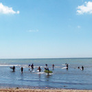
Fotos de Surf
de la galeríaContornos: Carreteras y Ríos: Selecciona un spot desde el menú 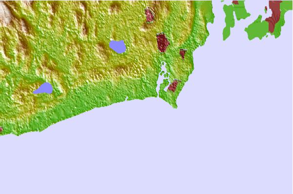
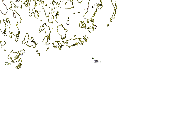
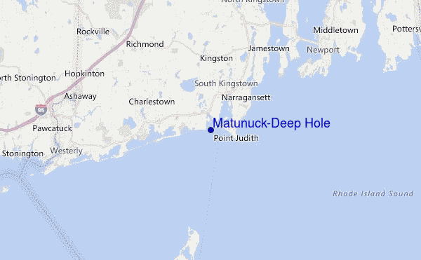
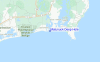
Usa este mapa para navegar hacia las playas de surf de Rhode Island y estaciones de marea cercanas de Matunuck-Deep Hole
Spots de Surf más cercanos a Matunuck-Deep Hole:
(Clica la ubicación para más detalles)- Closest spot0 mi
- Second closest spot1 mi
- Third closest spot1 mi
- Fourth closest spot2 mi
- Fifth closest spot2 mi
Boyas marinas más cercanas a Matunuck-Deep Hole:
- Closest Boya Marinas35 mi
- Second closest Boya Marinas55 mi
- Third closest Boya Marinas61 mi
- Fourth closest Boya Marinas70 mi
- Fifth closest Boya Marinas70 mi
Estaciones de marea más cercanas a Matunuck-Deep Hole:
- Closest estación de mareaMoonstone Beach1 mi
- Second closest estación de mareaPoint Judith Harbor of Refuge2 mi
- Third closest estación de mareaNarragansett Pier, Narragansett Bay5 mi
- Fourth closest estación de mareaCharlestown6 mi
- Fifth closest estación de mareaWatson Pier, Boston Neck, Narragansett Bay8 mi
Airports
- The closest passenger airport to Matunuck-Deep Hole is Theodore Francis Green State (Providence) Airport (PVD) in USA, 40 km (25 miles) away (directly).
- The second nearest airport to Matunuck-Deep Hole is North Central State (Smithfield) Airport (SFZ), also in USA, 61 km (38 miles) away.
- Third is Otis Angb (Falmouth) Airport (FMH) in USA, 90 km (56 miles) away.
- Hartford Brainard Airport (HFD) in USA is 101 km (63 miles) away.
- The Francis S Gabreski (West Hampton Beach) Airport (FOK), also in USA is the fifth nearest airport to Matunuck-Deep Hole and is 109 km (68 miles) away.
- /breaks/Matanuck_Deep-Hole/forecasts/latest
 Nearest