
Previsiones:

Pronóstico Corto PlazoAlgo de llovizna, más pesada durante la noche de jueves. Warm (max 26°C el martes por la noche, min 26°C el martes por la noche). Mayormente vientos frescos. | ||||||||||||||||||
mar 28 | miércoles 29 | jueves 30 | ||||||||||||||||
7 PM | 10 PM | 1 AM | 4 AM | 7 AM | 10 AM | 1 PM | 4 PM | 7 PM | 10 PM | 1 AM | 4 AM | 7 AM | 10 AM | 1 PM | 4 PM | 7 PM | 10 PM | |
Mapa de Altura de Olas | 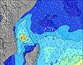 | 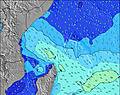 | 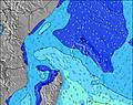 | 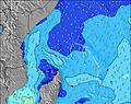 | 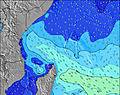 | 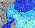 | 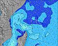 | |||||||||||
Oleaje Altura (m) Dirección Período (s) | SE 8 | SE 8 | SE 8 | SE 8 | SE 8 | SE 8 | SE 8 | SE 8 | SE 8 | SE 8 | S 18 | S 18 | ESE 9 | ESE 9 | SE 8 | ESE 8 | ESE 8 | ESE 9 |
Gráfico Olas | ||||||||||||||||||
567 | 581 | 560 | 560 | 475 | 475 | 427 | 463 | 507 | 481 | 399 | 395 | 281 | 275 | 446 | 256 | 256 | 254 | |
Viento (km/h) | ||||||||||||||||||
Estado del Viento Viento de Mar Viento de Mar-Cruzado Cruzado Viento de Tierra-Cruzado Viento de Tierra Cristalino | cross-off | cross-off | cross-off | cross-off | cross-off | cross-off | cross-off | cross | cross | cross | cross | cross | cross | cross | cross | cross | cross | cross |
Marea alta | 4:13PM1.16m | 4:59AM0.65m | 4:46PM1.20m | 5:30AM0.73m | 5:17PM1.21m | |||||||||||||
Marea baja | 11:17PM0.10m | 10:05AM0.25m | 11:42PM0.07m | 10:46AM0.24m | ||||||||||||||
— | — | — | 6:24 | — | — | — | — | — | — | — | 6:24 | — | — | — | — | — | — | |
— | — | — | — | — | — | — | 6:20 | — | — | — | — | — | — | — | 6:20 | — | — | |
mm | — | — | — | — | — | — | — | — | — | — | — | — | — | — | — | — | — | — |
Temp. °C | 26 | 26 | 26 | 26 | 26 | 26 | 26 | 26 | 26 | 26 | 26 | 26 | 26 | 26 | 26 | 26 | 26 | 26 |
Enfriamiento °C | 23 | 23 | 23 | 23 | 24 | 25 | 24 | 24 | 24 | 24 | 24 | 25 | 24 | 24 | 25 | 25 | 25 | 25 |
Oleaje 1 Altura (m) Dirección Período (s) | ESE 10 | ESE 11 | E 10 | E 10 | E 10 | E 10 | E 10 | S 20 | S 19 | S 18 | ESE 8 | ESE 9 | ESE 9 | ESE 9 | S 16 | ESE 8 | ESE 8 | ESE 9 |
108 | 88 | 56 | 56 | 100 | 74 | 74 | 276 | 270 | 318 | 244 | 322 | 281 | 275 | 254 | 256 | 256 | 254 | |
Oleaje 2 Altura (m) Dirección Período (s) | S 16 | S 16 | S 16 | S 16 | S 15 | S 14 | S 14 | S 14 | S 14 | E 10 | S 18 | S 18 | S 17 | S 16 | SSW 11 | S 16 | S 15 | S 15 |
132 | 127 | 124 | 119 | 112 | 102 | 95 | 92 | 61 | 53 | 399 | 395 | 270 | 257 | 22 | 248 | 216 | 208 | |
Oleaje 3 Altura (m) Dirección Período (s) | S 12 | S 12 | S 12 | SW 8 | SW 8 | S 21 | S 20 | SW 8 | SSW 9 | S 12 | E 10 | SSW 12 | SSW 12 | SSW 11 | SE 16 | SSW 11 | SE 16 | SE 15 |
11 | 25 | 24 | 10 | 10 | 79 | 124 | 10 | 8 | 25 | 73 | 47 | 46 | 41 | 42 | 22 | 40 | 36 | |
Olas de Viento Altura (m) Dirección Período (s) | SE 8 | SE 8 | SE 8 | SE 8 | SE 8 | SE 8 | SE 8 | SE 8 | SE 8 | SE 8 | SSE 8 | SSE 8 | SSE 8 | SSE 8 | SE 8 | SSE 8 | SSE 8 | SSE 8 |
567 | 581 | 560 | 560 | 475 | 475 | 427 | 463 | 507 | 481 | 232 | 235 | 223 | 202 | 446 | 169 | 207 | 229 | |
Viento del Tierra o Mar Limpio más proximo | ||||||||||||||||||
Distancia (km) | 1760 | 1789 | 1760 | 1760 | 1760 | 1772 | 1772 | 1765 | 1760 | 1760 | 1749 | 1760 | 1760 | 1760 | 1760 | 1765 | 1765 | 1765 |
Mejores Olas Previstas en Marianne Island | ||||||||||||||||||
Mejores Olas Previstas en Seychelles | ||||||||||||||||||
Busca-Olas Global | ||||||||||||||||||
- Map Icons:
 Break
Break Live Wave Height (m)
 Live Wind Speed (km/h)
 Surf Rating (10 Max)
 Ocean Swells (m)
- Wind Speed (km/h)
GRÁTIS! Un widget de Surf-Forecast.com para tu sitio
Este widget grátis de previsiones de surf y tiempo puede ser añadido a cualquier otro sitio y da un resumen de previsiones de olas para Marie Ann Island Shorey. Solo necesita cortar y pegar el código HTML de abajo en su web. Puede elegir preferencias de idioma y de unidades (métricas o imperiales) para convenir a los usuarios de su sitio. Clica aquí para obtener el código.
 Nearest