
Previsiones:

Pronóstico Corto PlazoLluvia ligera (totál 2mm), cayendo mayormente el miércoles por la tarde. Warm (max 28°C el miércoles por la tarde, min 16°C el miércoles por la noche). El viento será generalmente ligero. | |||||||||||||||||||||
mié 22 | jueves 23 | viernes 24 | |||||||||||||||||||
11 AM | 2 PM | 5 PM | 8 PM | 11 PM | 2 AM | 5 AM | 8 AM | 11 AM | 2 PM | 5 PM | 8 PM | 11 PM | 2 AM | 5 AM | 8 AM | 11 AM | 2 PM | 5 PM | 8 PM | 11 PM | |
Mapa de Altura de Olas | 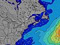 | 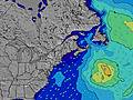 | 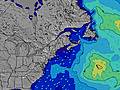 | 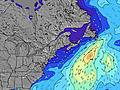 | 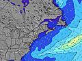 | 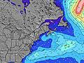 | 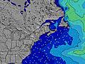 | 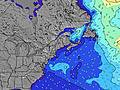 | |||||||||||||
Oleaje Altura (m) Dirección Período (s) | SSE 6 | SE 8 | SSE 7 | SE 9 | SE 7 | SSE 9 | SE 9 | SE 8 | SE 8 | SE 8 | SE 8 | SE 8 | SE 8 | SE 7 | SE 7 | SE 7 | SE 7 | SE 7 | SE 7 | SE 7 | SE 7 |
Gráfico Olas | |||||||||||||||||||||
0 | 34 | 0 | 42 | 65 | 0 | 115 | 100 | 77 | 122 | 119 | 96 | 67 | 65 | 51 | 48 | 48 | 48 | 41 | 31 | 32 | |
Viento (km/h) | |||||||||||||||||||||
Estado del Viento Viento de Mar Viento de Mar-Cruzado Cruzado Viento de Tierra-Cruzado Viento de Tierra Cristalino | off | off | off | off | cross-off | off | cross-off | cross | on | cross-on | cross | cross-off | off | glassy | glassy | glassy | cross-on | cross-on | cross | cross | cross-off |
Marea alta | 6:32PM3.05m | 7:10AM2.69m | 7:25PM3.00m | 8:07AM2.64m | 8:17PM3.00m | ||||||||||||||||
Marea baja | 12:13PM0.92m | 1:00AM0.81m | 1:07PM1.04m | 1:56AM0.84m | 2:00PM1.09m | ||||||||||||||||
— | — | — | — | — | — | 5:24 | — | — | — | — | — | — | — | 5:24 | — | — | — | — | — | — | |
— | — | — | 8:14 | — | — | — | — | — | — | — | 8:14 | — | — | — | — | — | — | — | 8:13 | — | |
mm | — | 1 | 1 | — | — | — | — | — | — | — | — | — | — | — | — | — | — | — | — | — | — |
Temp. °C | 25 | 26 | 28 | 24 | 21 | 18 | 16 | 17 | 21 | 22 | 20 | 19 | 20 | 18 | 18 | 17 | 21 | 23 | 23 | 21 | 21 |
Enfriamiento °C | 26 | 25 | 26 | 21 | 19 | 16 | 13 | 15 | 19 | 19 | 15 | 16 | 18 | 18 | 17 | 17 | 20 | 20 | 19 | 18 | 19 |
Oleaje 1 Altura (m) Dirección Período (s) | — | SSE 7 | SSE 7 | SSE 7 | SE 7 | SSE 9 | SE 9 | SE 8 | SE 8 | SE 8 | SE 8 | SE 8 | SE 8 | SE 7 | SE 7 | SE 7 | SE 7 | SE 7 | SE 7 | SE 7 | SE 7 |
— | 107 | 123 | 110 | 65 | 145 | 115 | 100 | 77 | 122 | 119 | 96 | 67 | 65 | 51 | 48 | 48 | 48 | 41 | 31 | 32 | |
Oleaje 2 Altura (m) Dirección Período (s) | — | SE 8 | — | SE 9 | SSE 9 | — | — | — | NNW 2 | — | — | — | — | — | — | SSE 9 | SSE 9 | SSE 8 | — | — | — |
— | 34 | — | 42 | 56 | — | — | — | 1 | — | — | — | — | — | — | 17 | 16 | 7 | — | — | — | |
Oleaje 3 Altura (m) Dirección Período (s) | — | — | — | — | — | — | — | — | — | — | — | — | — | — | — | — | — | — | — | — | — |
— | — | — | — | — | — | — | — | — | — | — | — | — | — | — | — | — | — | — | — | — | |
Olas de Viento Altura (m) Dirección Período (s) | SSE 6 | SSE 7 | — | — | W 3 | WNW 3 | — | — | — | — | — | — | — | — | — | — | — | — | — | SE 3 | SSE 3 |
149 | 210 | — | — | 1 | 1 | — | — | — | — | — | — | — | — | — | — | — | — | — | 2 | 4 | |
Viento del Tierra o Mar Limpio más proximo | |||||||||||||||||||||
Distancia (km) | 0 | 229 | 0 | 0 | 0 | 0 | 4 | 0 | 36 | 187 | 199 | 15 | 1 | 1 | 1 | 1 | 170 | 199 | 958 | 492 | 36 |
Mejores Olas Previstas en New Hampshire | |||||||||||||||||||||
Mejores Olas Previstas en United States | |||||||||||||||||||||
Busca-Olas Global | |||||||||||||||||||||
- Map Icons:
 Break
Break Live Wave Height (m)
 Live Wind Speed (km/h)
 Surf Rating (10 Max)
 Ocean Swells (m)
- Wind Speed (km/h)
GRÁTIS! Un widget de Surf-Forecast.com para tu sitio
Este widget grátis de previsiones de surf y tiempo puede ser añadido a cualquier otro sitio y da un resumen de previsiones de olas para Linkys. Solo necesita cortar y pegar el código HTML de abajo en su web. Puede elegir preferencias de idioma y de unidades (métricas o imperiales) para convenir a los usuarios de su sitio. Clica aquí para obtener el código.
 Nearest