
Previsiones:

Pronóstico Corto PlazoMayormente seco. Warm (max 26°C el sábado por la noche, min 25°C el sábado por la noche). El viento será generalmente ligero. | ||||||||||||||||||||||||
domingo 2 | lunes 3 | martes 4 | ||||||||||||||||||||||
1 AM | 4 AM | 7 AM | 10 AM | 1 PM | 4 PM | 7 PM | 10 PM | 1 AM | 4 AM | 7 AM | 10 AM | 1 PM | 4 PM | 7 PM | 10 PM | 1 AM | 4 AM | 7 AM | 10 AM | 1 PM | 4 PM | 7 PM | 10 PM | |
Mapa de Altura de Olas |  | 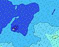 | 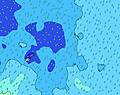 |  | 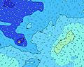 |  |  | 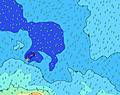 |  | |||||||||||||||
Oleaje Altura (m) Dirección Período (s) | E 8 | E 8 | E 8 | E 8 | E 8 | E 8 | E 8 | E 8 | E 8 | E 8 | E 8 | E 8 | E 8 | E 8 | ENE 8 | ENE 8 | ENE 8 | ENE 8 | ENE 8 | ENE 8 | ENE 8 | ENE 8 | ENE 8 | ENE 8 |
Gráfico Olas | ||||||||||||||||||||||||
208 | 182 | 182 | 157 | 161 | 157 | 169 | 137 | 134 | 157 | 157 | 127 | 127 | 127 | 101 | 101 | 101 | 101 | 79 | 79 | 81 | 79 | 83 | 63 | |
Viento (km/h) | ||||||||||||||||||||||||
Estado del Viento Viento de Mar Viento de Mar-Cruzado Cruzado Viento de Tierra-Cruzado Viento de Tierra Cristalino | cross-on | cross | cross | cross | cross-off | cross-off | cross | cross | cross | cross | cross | cross | cross | cross | cross | cross | cross-off | cross-off | cross | cross-off | cross-off | cross-off | cross-off | cross-off |
Marea alta | 8:24AM0.87m | 8:52PM0.80m | 9:08AM0.83m | 9:39PM0.80m | 9:59AM0.78m | |||||||||||||||||||
Marea baja | 2:19AM0.08m | 2:49PM0.04m | 3:02AM0.09m | 3:29PM0.07m | 3:55AM0.12m | 4:17PM0.10m | ||||||||||||||||||
— | 6:47 | — | — | — | — | — | — | — | 6:47 | — | — | — | — | — | — | — | 6:47 | — | — | — | — | — | — | |
— | — | — | — | — | 6:17 | — | — | — | — | — | — | — | 6:17 | — | — | — | — | — | — | — | 6:17 | — | — | |
mm | — | — | — | — | — | — | — | — | — | — | — | — | — | — | — | — | — | — | — | — | — | — | — | — |
Temp. °C | 25 | 25 | 26 | 26 | 26 | 26 | 26 | 26 | 26 | 26 | 26 | 26 | 26 | 26 | 26 | 26 | 26 | 26 | 26 | 26 | 26 | 26 | 26 | 25 |
Enfriamiento °C | 25 | 25 | 27 | 27 | 27 | 27 | 27 | 27 | 27 | 27 | 27 | 27 | 28 | 28 | 28 | 29 | 29 | 29 | 28 | 28 | 28 | 27 | 27 | 24 |
Oleaje 1 Altura (m) Dirección Período (s) | NE 11 | NE 11 | NE 11 | NE 11 | NE 11 | NE 10 | NE 10 | E 8 | E 8 | E 8 | E 8 | E 8 | E 8 | E 8 | ENE 8 | ENE 8 | ENE 8 | ENE 8 | ENE 8 | ENE 8 | ENE 8 | ENE 8 | ENE 8 | ENE 8 |
63 | 92 | 92 | 72 | 71 | 69 | 51 | 137 | 134 | 157 | 157 | 127 | 127 | 127 | 101 | 101 | 101 | 101 | 79 | 79 | 81 | 79 | 83 | 63 | |
Oleaje 2 Altura (m) Dirección Período (s) | SSE 13 | SE 12 | SE 12 | SE 12 | SE 12 | SSE 12 | SSE 12 | SSE 12 | SSE 12 | NE 11 | NE 11 | NE 11 | ENE 15 | NE 10 | NE 10 | NE 10 | NE 10 | NE 10 | NE 10 | NE 10 | SW 13 | SW 13 | SW 13 | SW 13 |
17 | 39 | 37 | 37 | 37 | 57 | 57 | 56 | 56 | 40 | 56 | 40 | 44 | 28 | 25 | 47 | 48 | 24 | 24 | 24 | 44 | 61 | 61 | 60 | |
Oleaje 3 Altura (m) Dirección Período (s) | NNE 10 | SSW 15 | ENE 18 | ENE 18 | ENE 18 | ENE 18 | ENE 17 | NE 10 | NE 10 | SE 12 | SE 11 | ENE 16 | NE 9 | ENE 15 | ENE 15 | ENE 15 | SE 12 | SE 12 | SW 13 | SW 13 | NE 9 | NE 13 | NE 9 | NE 9 |
9 | 22 | 31 | 61 | 61 | 60 | 56 | 25 | 25 | 34 | 33 | 49 | 22 | 85 | 84 | 84 | 35 | 35 | 44 | 44 | 23 | 46 | 21 | 21 | |
Olas de Viento Altura (m) Dirección Período (s) | E 8 | E 8 | E 8 | E 8 | E 8 | E 8 | E 8 | — | — | — | — | — | — | — | — | — | — | — | — | — | — | — | SE 2 | SE 3 |
208 | 182 | 182 | 157 | 161 | 157 | 169 | — | — | — | — | — | — | — | — | — | — | — | — | — | — | — | 1 | 4 | |
Viento del Tierra o Mar Limpio más proximo | ||||||||||||||||||||||||
Distancia (km) | 65 | 65 | 65 | 65 | 0 | 65 | 65 | 104 | 104 | 65 | 65 | 65 | 65 | 65 | 65 | 65 | 0 | 0 | 25 | 25 | 0 | 104 | 104 | 104 |
Mejores Olas Previstas en Upolu | ||||||||||||||||||||||||
Mejores Olas Previstas en Samoa | ||||||||||||||||||||||||
Busca-Olas Global | ||||||||||||||||||||||||
- Map Icons:
 Break
Break Live Wave Height (m)
 Live Wind Speed (km/h)
 Surf Rating (10 Max)
 Ocean Swells (m)
- Wind Speed (km/h)
GRÁTIS! Un widget de Surf-Forecast.com para tu sitio
Este widget grátis de previsiones de surf y tiempo puede ser añadido a cualquier otro sitio y da un resumen de previsiones de olas para Lautaunuu. Solo necesita cortar y pegar el código HTML de abajo en su web. Puede elegir preferencias de idioma y de unidades (métricas o imperiales) para convenir a los usuarios de su sitio. Clica aquí para obtener el código.
 Nearest