
Previsiones:

Pronóstico Corto PlazoMayormente seco. Warm (max 26°C el miércoles por la mañana, min 23°C el viernes por la noche). El viento será generalmente ligero. | |||||||||||||||||||||||
miércoles 29 | jueves 30 | viernes 31 | |||||||||||||||||||||
4 AM | 7 AM | 10 AM | 1 PM | 4 PM | 7 PM | 10 PM | 1 AM | 4 AM | 7 AM | 10 AM | 1 PM | 4 PM | 7 PM | 10 PM | 1 AM | 4 AM | 7 AM | 10 AM | 1 PM | 4 PM | 7 PM | 10 PM | |
Mapa de Altura de Olas |  | 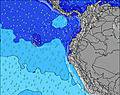 | 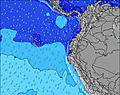 | 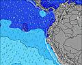 | 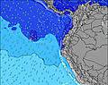 | 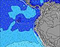 | 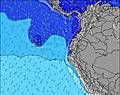 | 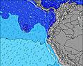 | 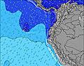 | ||||||||||||||
Oleaje Altura (m) Dirección Período (s) | WSW 15 | SW 15 | SW 14 | SW 14 | SW 14 | SW 14 | WSW 14 | WSW 14 | SW 13 | SW 13 | SW 13 | SW 13 | SW 13 | SW 13 | SW 13 | SW 13 | SW 12 | SW 12 | SW 12 | SW 13 | SW 13 | SW 12 | SW 12 |
Gráfico Olas | |||||||||||||||||||||||
730 | 773 | 763 | 667 | 658 | 648 | 523 | 493 | 412 | 406 | 406 | 400 | 394 | 331 | 326 | 316 | 306 | 306 | 306 | 311 | 265 | 223 | 216 | |
Viento (km/h) | |||||||||||||||||||||||
Estado del Viento Viento de Mar Viento de Mar-Cruzado Cruzado Viento de Tierra-Cruzado Viento de Tierra Cristalino | cross-on | cross | cross-on | cross-on | on | on | on | cross-on | cross-on | cross-on | cross-on | cross-on | cross-on | cross-on | cross-on | cross-on | cross-on | cross-on | cross-on | cross-on | on | cross-on | cross-on |
Marea alta | 4:02AM2.59m | 3:53PM2.58m | 4:34AM2.69m | 4:29PM2.64m | 5:06AM2.76m | 5:04PM2.68m | |||||||||||||||||
Marea baja | 9:59AM0.84m | 10:13PM0.39m | 10:34AM0.74m | 10:46PM0.34m | 11:08AM0.67m | ||||||||||||||||||
6:28 | — | — | — | — | — | — | — | 6:28 | — | — | — | — | — | — | — | 6:28 | — | — | — | — | — | — | |
— | — | — | — | 6:30 | — | — | — | — | — | — | — | 6:30 | — | — | — | — | — | — | — | 6:30 | — | — | |
mm | — | — | — | — | — | — | — | — | — | — | — | — | — | — | — | — | — | — | — | — | — | — | — |
Temp. °C | 24 | 24 | 25 | 26 | 25 | 24 | 24 | 24 | 24 | 24 | 24 | 26 | 25 | 24 | 24 | 24 | 24 | 24 | 24 | 25 | 25 | 24 | 24 |
Enfriamiento °C | 27 | 26 | 27 | 28 | 27 | 27 | 27 | 27 | 27 | 26 | 26 | 28 | 27 | 26 | 26 | 25 | 25 | 25 | 24 | 27 | 27 | 27 | 27 |
Oleaje 1 Altura (m) Dirección Período (s) | WSW 15 | SW 15 | SW 14 | SW 14 | SW 14 | SW 14 | WSW 14 | WSW 14 | SW 13 | SW 13 | SW 13 | SW 13 | SW 13 | SW 13 | SW 13 | SW 13 | SW 12 | SW 12 | SW 12 | SW 13 | SW 13 | SSW 6 | SW 12 |
730 | 773 | 763 | 667 | 658 | 648 | 523 | 493 | 412 | 406 | 406 | 400 | 394 | 331 | 326 | 316 | 306 | 306 | 306 | 311 | 265 | 67 | 216 | |
Oleaje 2 Altura (m) Dirección Período (s) | SSW 6 | NW 10 | NW 9 | NW 9 | NW 9 | NW 8 | SW 5 | SSW 5 | SSW 5 | NW 8 | NW 8 | SSW 6 | NW 8 | NW 8 | NW 8 | NW 8 | W 8 | W 8 | NW 11 | SW 18 | NW 11 | SW 12 | SSW 6 |
20 | 4 | 3 | 3 | 3 | 2 | 11 | 9 | 9 | 3 | 3 | 4 | 3 | 3 | 3 | 3 | 1 | 1 | 5 | 12 | 5 | 223 | 49 | |
Oleaje 3 Altura (m) Dirección Período (s) | NW 10 | — | — | W 12 | W 12 | W 9 | S 8 | SSW 8 | SSW 8 | — | — | NW 8 | — | — | — | — | — | — | SW 18 | NW 11 | SW 18 | SW 18 | WSW 17 |
4 | — | — | 3 | 3 | 2 | 4 | 6 | 6 | — | — | 3 | — | — | — | — | — | — | 13 | 5 | 12 | 12 | 29 | |
Olas de Viento Altura (m) Dirección Período (s) | — | — | — | — | — | — | — | — | — | SSW 5 | SSW 5 | SSW 4 | SSW 5 | SSW 5 | SSW 5 | SSW 5 | SSW 5 | SSW 6 | SSW 6 | SSW 6 | SSW 6 | — | — |
— | — | — | — | — | — | — | — | — | 9 | 13 | 12 | 15 | 14 | 14 | 19 | 24 | 60 | 94 | 94 | 80 | — | — | |
Viento del Tierra o Mar Limpio más proximo | |||||||||||||||||||||||
Distancia (km) | 67 | 39 | 39 | 67 | 986 | 67 | 67 | 67 | 67 | 39 | 39 | 986 | 986 | 986 | 39 | 39 | 39 | 236 | 236 | 67 | 67 | 67 | 76 |
Mejores Olas Previstas en Manabi | |||||||||||||||||||||||
Mejores Olas Previstas en Ecuador | |||||||||||||||||||||||
Busca-Olas Global | |||||||||||||||||||||||
- Map Icons:
 Break
Break Live Wave Height (m)
 Live Wind Speed (km/h)
 Surf Rating (10 Max)
 Ocean Swells (m)
- Wind Speed (km/h)
GRÁTIS! Un widget de Surf-Forecast.com para tu sitio
Este widget grátis de previsiones de surf y tiempo puede ser añadido a cualquier otro sitio y da un resumen de previsiones de olas para Las Tunas. Solo necesita cortar y pegar el código HTML de abajo en su web. Puede elegir preferencias de idioma y de unidades (métricas o imperiales) para convenir a los usuarios de su sitio. Clica aquí para obtener el código.
 Nearest