
Previsiones:

Pronóstico Corto PlazoLluvia moderada (totál 10mm), más pesada el viernes por la noche. Warm (max 34°C el viernes por la tarde, min 27°C el jueves por la noche). El viento será generalmente ligero. | |||||||||||||||||||
jue 30 | viernes 31 | sábado 1 | |||||||||||||||||
5 PM | 8 PM | 11 PM | 2 AM | 5 AM | 8 AM | 11 AM | 2 PM | 5 PM | 8 PM | 11 PM | 2 AM | 5 AM | 8 AM | 11 AM | 2 PM | 5 PM | 8 PM | 11 PM | |
Mapa de Altura de Olas | 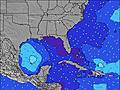 |  | 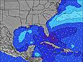 |  |  | 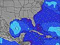 |  | ||||||||||||
Oleaje Altura (m) Dirección Período (s) | S 3 | S 4 | SSE 4 | SSE 4 | SSE 4 | S 4 | S 4 | E 6 | SE 3 | SSE 4 | SSE 4 | S 4 | SSE 4 | E 8 | E 8 | E 8 | SE 4 | SSE 4 | SSE 4 |
Gráfico Olas | |||||||||||||||||||
2 | 18 | 6 | 6 | 3 | 1 | 1 | 1 | 3 | 21 | 18 | 9 | 3 | 6 | 5 | 5 | 16 | 50 | 15 | |
Viento (km/h) | |||||||||||||||||||
Estado del Viento Viento de Mar Viento de Mar-Cruzado Cruzado Viento de Tierra-Cruzado Viento de Tierra Cristalino | cross-off | cross-off | glassy | off | off | off | cross-off | cross-off | cross-on | cross-on | cross-on | glassy | off | off | cross-off | cross-on | cross-on | cross | cross-off |
Marea alta | 9:44PM0.89m | 9:54AM0.77m | 10:20PM0.88m | 10:36AM0.80m | 10:57PM0.87m | ||||||||||||||
Marea baja | 3:14PM-0.00m | 3:48AM0.06m | 3:53PM0.01m | 4:24AM0.05m | 4:34PM0.04m | ||||||||||||||
— | — | — | — | 6:43 | — | — | — | — | — | — | — | 6:43 | — | — | — | — | — | — | |
— | 8:07 | — | — | — | — | — | — | — | 8:07 | — | — | — | — | — | — | — | 8:07 | — | |
mm | 1 | — | — | — | — | — | — | — | — | 2 | 2 | 1 | — | — | — | — | — | 2 | 1 |
Temp. °C | 31 | 30 | 29 | 28 | 27 | 27 | 31 | 34 | 33 | 32 | 31 | 30 | 28 | 27 | 30 | 32 | 32 | 30 | 30 |
Enfriamiento °C | 31 | 32 | 33 | 32 | 30 | 30 | 32 | 36 | 34 | 36 | 34 | 34 | 31 | 30 | 32 | 32 | 32 | 29 | 31 |
Oleaje 1 Altura (m) Dirección Período (s) | S 3 | SSE 4 | SSE 4 | SSE 4 | SSE 4 | S 4 | S 4 | NE 10 | NE 10 | NE 10 | NE 10 | S 4 | SSE 4 | SSE 4 | E 8 | E 8 | NE 9 | E 8 | E 8 |
2 | 5 | 6 | 6 | 3 | 1 | 1 | 4 | 4 | 4 | 4 | 9 | 3 | 1 | 5 | 5 | 3 | 5 | 5 | |
Oleaje 2 Altura (m) Dirección Período (s) | E 8 | — | E 8 | E 8 | E 8 | NE 10 | NE 10 | — | E 9 | E 9 | E 9 | NE 9 | NE 9 | E 8 | NE 9 | NE 9 | — | NE 9 | NE 8 |
1 | — | 1 | 1 | 1 | 4 | 4 | — | 2 | 2 | 2 | 3 | 3 | 6 | 3 | 3 | — | 3 | 3 | |
Oleaje 3 Altura (m) Dirección Período (s) | NE 9 | E 8 | — | NE 9 | NE 9 | E 6 | E 6 | E 6 | E 9 | — | — | E 7 | E 7 | NE 9 | — | — | — | — | — |
3 | 1 | — | 3 | 3 | 1 | 1 | 1 | 2 | — | — | 1 | 1 | 3 | — | — | — | — | — | |
Olas de Viento Altura (m) Dirección Período (s) | — | S 4 | — | — | — | — | — | — | SE 3 | SSE 4 | SSE 4 | — | WNW 3 | W 3 | SSW 3 | SE 3 | SE 4 | SSE 4 | SSE 4 |
— | 18 | — | — | — | — | — | — | 3 | 21 | 18 | — | 2 | 1 | 1 | 2 | 16 | 50 | 15 | |
Viento del Tierra o Mar Limpio más proximo | |||||||||||||||||||
Distancia (km) | 1048 | 1374 | 957 | 1054 | 992 | 362 | 306 | 362 | 306 | 369 | 278 | 941 | 992 | 941 | 1598 | 817 | 362 | 313 | 43 |
Mejores Olas Previstas en South Florida | |||||||||||||||||||
Mejores Olas Previstas en United States | |||||||||||||||||||
Busca-Olas Global | |||||||||||||||||||
- Map Icons:
 Break
Break Live Wave Height (m)
 Live Wind Speed (km/h)
 Surf Rating (10 Max)
 Ocean Swells (m)
- Wind Speed (km/h)
GRÁTIS! Un widget de Surf-Forecast.com para tu sitio
Este widget grátis de previsiones de surf y tiempo puede ser añadido a cualquier otro sitio y da un resumen de previsiones de olas para Lantana. Solo necesita cortar y pegar el código HTML de abajo en su web. Puede elegir preferencias de idioma y de unidades (métricas o imperiales) para convenir a los usuarios de su sitio. Clica aquí para obtener el código.
 Nearest