
Previsiones:

Pronóstico Corto PlazoLluvia ligera (totál 8mm), cayendo mayormente el lunes por la noche. Very mild (max 15°C el miércoles por la mañana, min 11°C el lunes por la mañana). El viento será generalmente ligero. | ||||||||||||||||||||||
lunes 3 | martes 4 | miércoles 5 | ||||||||||||||||||||
6 AM | 9 AM | 12 PM | 3 PM | 6 PM | 9 PM | 12 AM | 3 AM | 6 AM | 9 AM | 12 PM | 3 PM | 6 PM | 9 PM | 12 AM | 3 AM | 6 AM | 9 AM | 12 PM | 3 PM | 6 PM | 9 PM | |
Mapa de Altura de Olas | 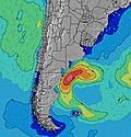 | 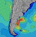 | 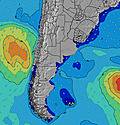 | 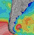 | 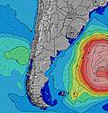 | 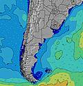 | 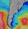 | 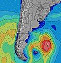 | ||||||||||||||
Oleaje Altura (m) Dirección Período (s) | SSE 12 | SSE 11 | SSE 11 | SSE 11 | SSE 11 | SSE 11 | SSE 11 | SSE 11 | SSE 11 | SSE 11 | SE 11 | SE 10 | SE 10 | SE 10 | SE 10 | SE 10 | SE 9 | SE 9 | SE 9 | SE 9 | SE 9 | SE 9 |
Gráfico Olas | ||||||||||||||||||||||
145 | 170 | 217 | 217 | 230 | 247 | 247 | 204 | 204 | 238 | 163 | 124 | 117 | 77 | 77 | 76 | 70 | 52 | 51 | 51 | 51 | 51 | |
Viento (km/h) | ||||||||||||||||||||||
Estado del Viento Viento de Mar Viento de Mar-Cruzado Cruzado Viento de Tierra-Cruzado Viento de Tierra Cristalino | cross-off | cross-off | cross | cross | cross-on | cross-on | on | cross-on | cross-on | on | on | on | cross-on | cross-on | cross | cross | cross | cross-off | cross | cross | cross-on | cross |
Marea alta | 3:53AM0.21m | 10:24AM0.33m | 4:27PM0.20m | 10:46PM0.36m | 4:48AM0.21m | 11:07AM0.36m | 5:07PM0.18m | 11:34PM0.34m | 5:46AM0.21m | 11:52AM0.40m | 5:47PM0.15m | |||||||||||
Marea baja | 6:48AM0.11m | 1:54PM0.13m | 7:04PM0.13m | 2:22AM0.15m | 7:26AM0.13m | 2:52PM0.13m | 7:48PM0.10m | 3:08AM0.14m | 8:04AM0.16m | 3:58PM0.13m | 8:34PM0.08m | |||||||||||
7:28 | — | — | — | — | — | — | — | 7:28 | — | — | — | — | — | — | — | 7:26 | — | — | — | — | — | |
— | — | — | 5:57 | — | — | — | — | — | — | — | 5:57 | — | — | — | — | — | — | — | 5:58 | — | — | |
mm | — | — | — | — | 1 | 3 | — | — | — | — | — | — | — | — | — | — | — | — | 1 | 2 | 1 | — |
Temp. °C | 11 | 11 | 13 | 14 | 14 | 14 | 14 | 14 | 14 | 14 | 14 | 14 | 14 | 14 | 14 | 14 | 14 | 14 | 15 | 15 | 15 | 14 |
Enfriamiento °C | 8 | 9 | 11 | 12 | 13 | 13 | 14 | 14 | 13 | 13 | 12 | 12 | 13 | 13 | 13 | 13 | 12 | 12 | 14 | 14 | 15 | 13 |
Oleaje 1 Altura (m) Dirección Período (s) | SSE 12 | SSE 11 | SSE 11 | SSE 11 | SSE 11 | SSE 11 | SSE 11 | SSE 11 | SSE 11 | SSE 11 | SE 11 | SE 10 | SSE 6 | SSE 6 | SE 6 | SE 6 | SE 6 | SE 6 | SE 6 | SE 6 | ESE 6 | ESE 6 |
145 | 170 | 217 | 217 | 230 | 247 | 247 | 204 | 204 | 238 | 163 | 124 | 41 | 41 | 39 | 31 | 31 | 26 | 28 | 28 | 22 | 21 | |
Oleaje 2 Altura (m) Dirección Período (s) | ENE 8 | ENE 9 | ENE 8 | ENE 8 | ENE 8 | E 8 | E 8 | E 8 | ENE 8 | ENE 8 | ENE 8 | ENE 7 | SE 10 | SE 10 | SE 10 | SE 10 | SE 9 | SE 9 | SE 9 | SE 9 | SE 9 | SE 9 |
41 | 31 | 41 | 40 | 24 | 22 | 21 | 20 | 12 | 12 | 11 | 17 | 117 | 77 | 77 | 76 | 70 | 52 | 51 | 51 | 51 | 51 | |
Oleaje 3 Altura (m) Dirección Período (s) | — | — | — | E 13 | — | E 10 | E 12 | — | E 10 | — | — | S 12 | ENE 7 | ENE 7 | ENE 7 | ENE 7 | ENE 7 | ENE 7 | ENE 7 | ENE 7 | ENE 7 | ENE 7 |
— | — | — | 3 | — | 2 | 3 | — | 2 | — | — | 3 | 17 | 16 | 16 | 17 | 16 | 16 | 16 | 9 | 9 | 9 | |
Olas de Viento Altura (m) Dirección Período (s) | — | — | — | — | — | — | — | — | S 3 | S 4 | SSE 4 | SSE 5 | — | — | — | — | — | ENE 7 | — | — | — | — |
— | — | — | — | — | — | — | — | 1 | 6 | 15 | 28 | — | — | — | — | — | 37 | — | — | — | — | |
Viento del Tierra o Mar Limpio más proximo | ||||||||||||||||||||||
Distancia (km) | 0 | 0 | 3 | 48 | 48 | 48 | 48 | 6 | 6 | 55 | 478 | 483 | 478 | 5 | 5 | 5 | 5 | 0 | 5 | 5 | 5 | 5 |
Mejores Olas Previstas en Uruguay - North | ||||||||||||||||||||||
Mejores Olas Previstas en Uruguay | ||||||||||||||||||||||
Busca-Olas Global | ||||||||||||||||||||||
- Map Icons:
 Break
Break Live Wave Height (m)
 Live Wind Speed (km/h)
 Surf Rating (10 Max)
 Ocean Swells (m)
- Wind Speed (km/h)
GRÁTIS! Un widget de Surf-Forecast.com para tu sitio
Este widget grátis de previsiones de surf y tiempo puede ser añadido a cualquier otro sitio y da un resumen de previsiones de olas para Laguna de Rocha. Solo necesita cortar y pegar el código HTML de abajo en su web. Puede elegir preferencias de idioma y de unidades (métricas o imperiales) para convenir a los usuarios de su sitio. Clica aquí para obtener el código.
 Nearest