
Previsiones:

Pronóstico Corto PlazoAlgo de llovizna, más pesada durante la noche de miércoles. Warm (max 26°C el lunes por la noche, min 25°C el miércoles por la noche). Mayormente vientos frescos. | ||||||||||||||||||
lun 27 | martes 28 | miércoles 29 | ||||||||||||||||
7 PM | 10 PM | 1 AM | 4 AM | 7 AM | 10 AM | 1 PM | 4 PM | 7 PM | 10 PM | 1 AM | 4 AM | 7 AM | 10 AM | 1 PM | 4 PM | 7 PM | 10 PM | |
Mapa de Altura de Olas | 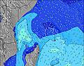 | 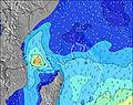 | 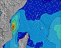 | 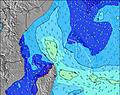 | 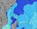 | 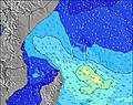 | 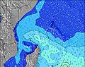 | |||||||||||
Oleaje Altura (m) Dirección Período (s) | SE 6 | SE 6 | SE 7 | SE 9 | SE 9 | SE 7 | SE 8 | SE 8 | SE 8 | SE 8 | SE 8 | SE 8 | SE 8 | SE 8 | SE 8 | SE 8 | SE 8 | SSW 18 |
Gráfico Olas | ||||||||||||||||||
263 | 280 | 325 | 567 | 554 | 392 | 444 | 456 | 519 | 532 | 574 | 532 | 532 | 498 | 498 | 470 | 470 | 470 | |
Viento (km/h) | ||||||||||||||||||
Estado del Viento Viento de Mar Viento de Mar-Cruzado Cruzado Viento de Tierra-Cruzado Viento de Tierra Cristalino | on | on | on | on | on | on | on | on | on | on | on | on | on | on | on | on | on | on |
Marea alta | 4:28AM0.77m | 4:21PM1.33m | 5:00AM0.85m | 4:55PM1.38m | ||||||||||||||
Marea baja | 10:46PM0.19m | 9:41AM0.31m | 11:14PM0.14m | 10:22AM0.27m | ||||||||||||||
— | — | — | 6:26 | — | — | — | — | — | — | — | 6:26 | — | — | — | — | — | — | |
— | — | — | — | — | — | — | 6:21 | — | — | — | — | — | — | — | 6:21 | — | — | |
mm | — | — | — | — | — | — | — | — | — | — | — | — | — | — | — | — | — | — |
Temp. °C | 26 | 26 | 26 | 26 | 26 | 26 | 26 | 26 | 26 | 26 | 26 | 26 | 26 | 26 | 26 | 26 | 26 | 26 |
Enfriamiento °C | 25 | 25 | 24 | 24 | 24 | 25 | 24 | 24 | 24 | 24 | 24 | 24 | 23 | 24 | 24 | 25 | 24 | 25 |
Oleaje 1 Altura (m) Dirección Período (s) | S 10 | S 10 | S 10 | E 12 | ESE 11 | E 11 | S 18 | S 17 | S 16 | S 16 | S 16 | S 16 | S 15 | S 14 | S 20 | S 19 | S 19 | SSW 18 |
70 | 70 | 67 | 42 | 42 | 62 | 165 | 149 | 135 | 132 | 129 | 122 | 112 | 107 | 198 | 273 | 361 | 432 | |
Oleaje 2 Altura (m) Dirección Período (s) | SSW 14 | SSW 13 | SSW 21 | SSW 21 | SSW 20 | SSW 18 | ESE 11 | E 11 | SSW 12 | SSW 12 | SSW 11 | SSW 10 | SSW 10 | SSW 21 | SSW 14 | SSW 13 | S 12 | SSW 12 |
37 | 35 | 144 | 141 | 131 | 112 | 41 | 39 | 28 | 26 | 25 | 22 | 20 | 148 | 62 | 141 | 78 | 47 | |
Oleaje 3 Altura (m) Dirección Período (s) | SSW 21 | SSW 21 | SSW 13 | SSW 13 | SSW 13 | SSW 13 | SSW 12 | SSW 12 | SW 9 | SW 8 | SW 8 | SW 8 | SSW 21 | SSW 10 | SSW 10 | E 16 | SW 8 | SSW 8 |
89 | 87 | 35 | 34 | 17 | 16 | 15 | 29 | 12 | 11 | 11 | 11 | 88 | 20 | 20 | 5 | 10 | 7 | |
Olas de Viento Altura (m) Dirección Período (s) | SE 6 | SE 6 | SE 7 | SE 9 | SE 9 | SE 7 | SE 8 | SE 8 | SE 8 | SE 8 | SE 8 | SE 8 | SE 8 | SE 8 | SE 8 | SE 8 | SE 8 | SE 8 |
263 | 280 | 325 | 567 | 554 | 392 | 444 | 456 | 519 | 532 | 574 | 532 | 532 | 498 | 498 | 470 | 470 | 470 | |
Viento del Tierra o Mar Limpio más proximo | ||||||||||||||||||
Distancia (km) | 1709 | 1720 | 1720 | 1720 | 1720 | 1725 | 1732 | 1732 | 1749 | 1732 | 1720 | 1720 | 1720 | 1732 | 1725 | 1720 | 1720 | 1720 |
Mejores Olas Previstas en Mahe | ||||||||||||||||||
Mejores Olas Previstas en Seychelles | ||||||||||||||||||
Busca-Olas Global | ||||||||||||||||||
- Map Icons:
 Break
Break Live Wave Height (m)
 Live Wind Speed (km/h)
 Surf Rating (10 Max)
 Ocean Swells (m)
- Wind Speed (km/h)
GRÁTIS! Un widget de Surf-Forecast.com para tu sitio
Este widget grátis de previsiones de surf y tiempo puede ser añadido a cualquier otro sitio y da un resumen de previsiones de olas para La Passe. Solo necesita cortar y pegar el código HTML de abajo en su web. Puede elegir preferencias de idioma y de unidades (métricas o imperiales) para convenir a los usuarios de su sitio. Clica aquí para obtener el código.
 Nearest