
Previsiones:

Pronóstico Corto PlazoLluvia moderada (totál 14mm), más pesada el lunes por la noche. Very mild (max 16°C el lunes por la noche, min 12°C el lunes por la mañana). El viento será generalmente ligero. | ||||||||||||||||||||||||
lunes 3 | martes 4 | miércoles 5 | ||||||||||||||||||||||
12 AM | 3 AM | 6 AM | 9 AM | 12 PM | 3 PM | 6 PM | 9 PM | 12 AM | 3 AM | 6 AM | 9 AM | 12 PM | 3 PM | 6 PM | 9 PM | 12 AM | 3 AM | 6 AM | 9 AM | 12 PM | 3 PM | 6 PM | 9 PM | |
Mapa de Altura de Olas |  | 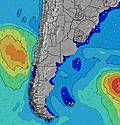 | 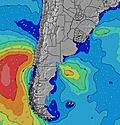 | 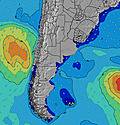 | 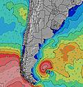 | 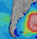 | 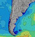 | 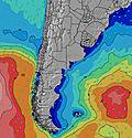 | 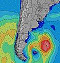 | |||||||||||||||
Oleaje Altura (m) Dirección Período (s) | E 9 | S 8 | SSE 12 | SSE 12 | SSE 11 | SSE 11 | SSE 11 | SSE 11 | SSE 11 | SSE 11 | SSE 11 | SE 11 | SE 11 | SE 10 | SSE 10 | SSE 10 | SSE 10 | SE 10 | SE 10 | SE 9 | SE 9 | SE 9 | SE 9 | SE 9 |
Gráfico Olas | ||||||||||||||||||||||||
26 | 31 | 113 | 109 | 135 | 143 | 140 | 157 | 154 | 151 | 149 | 119 | 115 | 108 | 88 | 125 | 64 | 46 | 44 | 41 | 40 | 79 | 29 | 29 | |
Viento (km/h) | ||||||||||||||||||||||||
Estado del Viento Viento de Mar Viento de Mar-Cruzado Cruzado Viento de Tierra-Cruzado Viento de Tierra Cristalino | cross | cross-off | cross-off | cross-off | cross | cross | cross-off | cross-off | cross-off | glassy | cross-on | cross-on | cross-on | cross-on | on | cross-on | cross | cross-off | glassy | cross | glassy | glassy | glassy | on |
Marea alta | 10:22PM0.54m | 4:12AM0.31m | 10:46AM0.40m | 4:57PM0.29m | 11:08PM0.54m | 5:03AM0.30m | 11:29AM0.46m | 5:41PM0.25m | 11:55PM0.52m | 6:00AM0.28m | 12:14PM0.52m | 6:26PM0.20m | ||||||||||||
Marea baja | 1:55AM0.22m | 7:22AM0.09m | 2:04PM0.13m | 7:29PM0.17m | 2:43AM0.20m | 7:59AM0.13m | 3:03PM0.13m | 8:09PM0.14m | 3:33AM0.19m | 8:36AM0.17m | 4:07PM0.12m | 8:52PM0.11m | ||||||||||||
— | — | 7:24 | — | — | — | — | — | — | — | 7:24 | — | — | — | — | — | — | — | 7:22 | — | — | — | — | — | |
— | — | — | — | — | 5:54 | — | — | — | — | — | — | — | 5:55 | — | — | — | — | — | — | — | 5:57 | — | — | |
mm | — | — | — | — | — | — | 2 | 4 | 1 | 1 | 1 | 1 | — | — | — | — | — | — | — | — | 1 | 2 | 1 | — |
Temp. °C | 11 | 11 | 12 | 12 | 14 | 14 | 15 | 15 | 16 | 16 | 16 | 14 | 15 | 16 | 14 | 15 | 15 | 14 | 14 | 14 | 14 | 15 | 15 | 14 |
Enfriamiento °C | 9 | 8 | 11 | 11 | 13 | 13 | 15 | 15 | 16 | 17 | 16 | 12 | 14 | 16 | 13 | 15 | 15 | 13 | 14 | 14 | 14 | 16 | 16 | 14 |
Oleaje 1 Altura (m) Dirección Período (s) | S 7 | S 8 | SSE 12 | SSE 12 | SSE 11 | SSE 11 | SSE 11 | SSE 11 | SSE 11 | SSE 11 | SSE 11 | SE 11 | SE 11 | SE 10 | SSE 10 | SSE 10 | SSE 6 | SE 6 | SE 6 | SE 6 | SE 6 | SE 9 | SE 6 | SE 6 |
26 | 29 | 113 | 109 | 135 | 143 | 140 | 157 | 154 | 151 | 149 | 119 | 115 | 108 | 88 | 125 | 33 | 39 | 33 | 34 | 24 | 79 | 21 | 12 | |
Oleaje 2 Altura (m) Dirección Período (s) | E 9 | SSE 12 | E 9 | ENE 9 | ENE 8 | E 8 | E 8 | E 8 | ENE 4 | ENE 5 | E 5 | E 6 | E 7 | E 7 | E 7 | E 7 | SSE 10 | SE 10 | SE 10 | SE 9 | SE 9 | E 7 | SE 9 | SE 9 |
25 | 31 | 39 | 25 | 24 | 22 | 12 | 5 | 6 | 7 | 13 | 21 | 26 | 25 | 25 | 25 | 64 | 46 | 44 | 41 | 40 | 8 | 29 | 29 | |
Oleaje 3 Altura (m) Dirección Período (s) | SSE 13 | E 9 | SSE 12 | — | — | — | — | E 12 | E 8 | E 8 | SE 11 | SE 10 | SE 11 | E 10 | S 12 | S 12 | E 7 | E 7 | E 7 | E 7 | E 7 | S 10 | E 7 | E 7 |
17 | 14 | 113 | — | — | — | — | 3 | 5 | 5 | 5 | 4 | 5 | 2 | 3 | 3 | 15 | 15 | 15 | 15 | 8 | 2 | 8 | 8 | |
Olas de Viento Altura (m) Dirección Período (s) | ENE 3 | ENE 4 | — | ENE 8 | — | ENE 8 | ENE 4 | ENE 4 | ENE 8 | — | — | SSW 2 | S 3 | S 3 | — | — | — | — | — | — | — | — | — | — |
2 | 2 | — | 57 | — | 53 | 4 | 5 | 78 | — | — | 1 | 1 | 1 | — | — | — | — | — | — | — | — | — | — | |
Viento del Tierra o Mar Limpio más proximo | ||||||||||||||||||||||||
Distancia (km) | 3 | 0 | 0 | 0 | 2 | 2 | 0 | 0 | 0 | 0 | 1 | 1 | 1 | 1 | 498 | 2 | 2 | 0 | 0 | 2 | 0 | 0 | 0 | 29 |
Mejores Olas Previstas en Uruguay - North | ||||||||||||||||||||||||
Mejores Olas Previstas en Uruguay | ||||||||||||||||||||||||
Busca-Olas Global | ||||||||||||||||||||||||
- Map Icons:
 Break
Break Live Wave Height (m)
 Live Wind Speed (km/h)
 Surf Rating (10 Max)
 Ocean Swells (m)
- Wind Speed (km/h)
GRÁTIS! Un widget de Surf-Forecast.com para tu sitio
Este widget grátis de previsiones de surf y tiempo puede ser añadido a cualquier otro sitio y da un resumen de previsiones de olas para La Moza. Solo necesita cortar y pegar el código HTML de abajo en su web. Puede elegir preferencias de idioma y de unidades (métricas o imperiales) para convenir a los usuarios de su sitio. Clica aquí para obtener el código.
 Nearest