

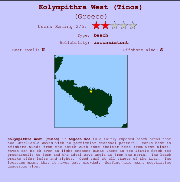
Kolympithra West (Tinos) Surf Guide
Kolympithra West (Tinos) in Aegean Sea is a reasonably exposed beach break that has inconsistent surf with no particular seasonal pattern. Offshore winds blow from the south with some shelter here from west winds. Still reasonable in light onshore winds There is too little fetch for groundswells to form and the ideal wave direction is from the north. Waves at the beach are both lefts and rights. The quality of the surf isn't affected by the tide. Even when the surf is up, crowds are unknown. Take care of the strong rips here.
Kolympithra West (Tinos) Spot Info
| Type: | Rating: | Reliability: | Todays Sea Temp*: |
|---|---|---|---|
| inconsistent | 24.7°C*ocean temperature recorded from satellite |
Surfing Kolympithra West (Tinos):
The best conditions reported for surf at Kolympithra West (Tinos) occur when a North swell combines with an offshore wind direction from the South.
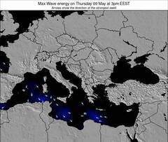
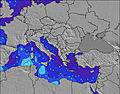
Energía de Olas (poder): 12 horas

Kolympithra West (Tinos) Surf:
Tuesday, 28 July 2026, 11:09 Local time| martes 28 | ||||
| 6AM | 9AM | 12PM | 3PM | |
| Wave (m) | ||||
| Período (s) | - | 2 | 3 | 4 |
| Viento (km/h) | ||||
| Estado del Viento | on | on | on | on |
- /breaks/Kolympithra-West-Tinos/forecasts/latest
Kolympithra West (Tinos) Surf Guide
Kolympithra West (Tinos) in Aegean Sea is a reasonably exposed beach break that has inconsistent surf with no particular seasonal pattern. Offshore winds blow from the south with some shelter here from west winds. Still reasonable in light onshore winds There is too little fetch for groundswells to form and the ideal wave direction is from the north. Waves at the beach are both lefts and rights. The quality of the surf isn't affected by the tide. Even when the surf is up, crowds are unknown. Take care of the strong rips here.
Kolympithra West (Tinos) Spot Info
Type: Rating: Reliability: Todays Sea Temp*:  Beach
Beach 2
2inconsistent 24.7°C*ocean temperature recorded from satelliteSurfing Kolympithra West (Tinos):
The best conditions reported for surf at Kolympithra West (Tinos) occur when a North swell combines with an offshore wind direction from the South.
Energía de Olas (poder): 12 horas
Usa la barra de navegación de arriba para ver la temperatura del mar en Kolympithra West (Tinos), fotografías Kolympithra West (Tinos), previsiones detalladas de olas para Kolympithra West (Tinos), vientos y previsión del tiempo, webcams para Kolympithra West (Tinos), viento actual desde estaciones meteorológicas en Aegean Sea y predicciones de marea para Kolympithra West (Tinos). Las mapas de olas para Greece enseñarán un mapa grande de Greece y los mares que rodean. Los mapas de olas pueden ser animadas para mostrar diferentes componentes de olas, la altura de ola, la energía de ola, el período, junto con previsiones de viento y del tiempo. Previsiones actuales del tiempo y del estado del mar provienen de boyas marinas de Greece, del barcos que transitan en la zona y de estaciones meteorológicas costeras. Cada página de previsiones tiene un Busca-Olas Regional y Global para localizar las mejores condiciones para surfear en el área de Kolympithra West (Tinos).
Kolympithra West (Tinos) Surf:
Tuesday, 28 July 2026, 11:09 Local timemartes 28 6AM 9AM 12PM 3PM Wave (m) Período (s) - 2 3 4 Viento (km/h) Estado del Viento on on on on - /breaks/Kolympithra-West-Tinos/forecasts/latest
- /breaks/Kolympithra-West-Tinos/forecasts/latest/six_day
Kolympithra West (Tinos) Surf Guide
Kolympithra West (Tinos) in Aegean Sea is a reasonably exposed beach break that has inconsistent surf with no particular seasonal pattern. Offshore winds blow from the south with some shelter here from west winds. Still reasonable in light onshore winds There is too little fetch for groundswells to form and the ideal wave direction is from the north. Waves at the beach are both lefts and rights. The quality of the surf isn't affected by the tide. Even when the surf is up, crowds are unknown. Take care of the strong rips here.
Kolympithra West (Tinos) Spot Info
Type: Rating: Reliability: Todays Sea Temp*: Beach2inconsistent 24.7°C*ocean temperature recorded from satelliteSurfing Kolympithra West (Tinos):
The best conditions reported for surf at Kolympithra West (Tinos) occur when a North swell combines with an offshore wind direction from the South.
Energía de Olas (poder): 12 horas
Usa la barra de navegación de arriba para ver la temperatura del mar en Kolympithra West (Tinos), fotografías Kolympithra West (Tinos), previsiones detalladas de olas para Kolympithra West (Tinos), vientos y previsión del tiempo, webcams para Kolympithra West (Tinos), viento actual desde estaciones meteorológicas en Aegean Sea y predicciones de marea para Kolympithra West (Tinos). Las mapas de olas para Greece enseñarán un mapa grande de Greece y los mares que rodean. Los mapas de olas pueden ser animadas para mostrar diferentes componentes de olas, la altura de ola, la energía de ola, el período, junto con previsiones de viento y del tiempo. Previsiones actuales del tiempo y del estado del mar provienen de boyas marinas de Greece, del barcos que transitan en la zona y de estaciones meteorológicas costeras. Cada página de previsiones tiene un Busca-Olas Regional y Global para localizar las mejores condiciones para surfear en el área de Kolympithra West (Tinos).
Kolympithra West (Tinos) Surf:
Tuesday, 28 July 2026, 11:09 Local timemartes 28 6AM 9AM 12PM 3PM Wave (m) Período (s) - 2 3 4 Viento (km/h) Estado del Viento on on on on - /breaks/Kolympithra-West-Tinos/forecasts/latest
Kolympithra West (Tinos) Surf Guide
Kolympithra West (Tinos) in Aegean Sea is a reasonably exposed beach break that has inconsistent surf with no particular seasonal pattern. Offshore winds blow from the south with some shelter here from west winds. Still reasonable in light onshore winds There is too little fetch for groundswells to form and the ideal wave direction is from the north. Waves at the beach are both lefts and rights. The quality of the surf isn't affected by the tide. Even when the surf is up, crowds are unknown. Take care of the strong rips here.
Kolympithra West (Tinos) Spot Info
Type: Rating: Reliability: Todays Sea Temp*: Beach2inconsistent 24.7°C*ocean temperature recorded from satelliteSurfing Kolympithra West (Tinos):
The best conditions reported for surf at Kolympithra West (Tinos) occur when a North swell combines with an offshore wind direction from the South.
Energía de Olas (poder): 12 horas
Usa la barra de navegación de arriba para ver la temperatura del mar en Kolympithra West (Tinos), fotografías Kolympithra West (Tinos), previsiones detalladas de olas para Kolympithra West (Tinos), vientos y previsión del tiempo, webcams para Kolympithra West (Tinos), viento actual desde estaciones meteorológicas en Aegean Sea y predicciones de marea para Kolympithra West (Tinos). Las mapas de olas para Greece enseñarán un mapa grande de Greece y los mares que rodean. Los mapas de olas pueden ser animadas para mostrar diferentes componentes de olas, la altura de ola, la energía de ola, el período, junto con previsiones de viento y del tiempo. Previsiones actuales del tiempo y del estado del mar provienen de boyas marinas de Greece, del barcos que transitan en la zona y de estaciones meteorológicas costeras. Cada página de previsiones tiene un Busca-Olas Regional y Global para localizar las mejores condiciones para surfear en el área de Kolympithra West (Tinos).
Kolympithra West (Tinos) Surf:
Tuesday, 28 July 2026, 11:09 Local timemartes 28 6AM 9AM 12PM 3PM Wave (m) Período (s) - 2 3 4 Viento (km/h) Estado del Viento on on on on Tide Times:
Para Kolympithra East (Tinos), a %{dist} %{km} de %{location}.
PROXIMA ES A LAS (hora local) quedan marea alta marea baja Kolympithra West (Tinos) Tide Times and Tide Chart
Live Weather:
At Mikonos Island Airport, 28 km from Kolympithra West (Tinos).
fresh winds from the NNE
(km/h)Air temperature
Q1014°CFotos de Surf
de la galeríaContornos: Carreteras y Ríos: Selecciona un spot desde el menú 


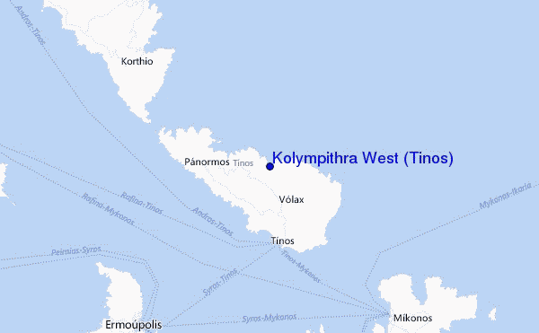
Usa este mapa para navegar hacia las playas de surf de Aegean Sea y estaciones de marea cercanas de Kolympithra West (Tinos)
Spots de Surf más cercanos a Kolympithra West (Tinos):
(Clica la ubicación para más detalles)- Closest spot0 mi
- Second closest spot1 mi
- Third closest spot6 mi
- Fourth closest spot19 mi
- Fifth closest spot25 mi
Boyas marinas más cercanas a Kolympithra West (Tinos):
- Closest Boya Marinas993 mi
- Second closest Boya Marinas1125 mi
- Third closest Boya Marinas1469 mi
- Fourth closest Boya Marinas1472 mi
- Fifth closest Boya Marinas1489 mi
Estaciones de marea más cercanas a Kolympithra West (Tinos):
- Closest estación de mareaMykonos16 mi
- Second closest estación de mareaErmoupolis17 mi
- Third closest estación de mareaNaxos39 mi
- Fourth closest estación de mareaKáristos48 mi
- Fifth closest estación de mareaLavrion60 mi
Airports
- The closest passenger airport to Kolympithra West (Tinos) is Mikonos (Mykonos) Airport (JMK) in Greece, 28 km (17 miles) away (directly).
- The second nearest airport to Kolympithra West (Tinos) is Chios Airport (JKH), also in Greece, 118 km (73 miles) away.
- Third is Athinai (Athens) Airport (HEW) in Greece, 127 km (79 miles) away.
- Santorini Airport (JTR) in Greece is 140 km (87 miles) away.
- Leros Airport (LRS), also in Greece is the fifth nearest airport to Kolympithra West (Tinos) and is 155 km (96 miles) away.
- /breaks/Kolympithra-West-Tinos/forecasts/latest
 Nearest