
Previsiones:

Pronóstico Corto PlazoFuerte lluvia (totál 26mm), más pesada durante la noche de lunes. Warm (max 30°C el martes por la mañana, min 29°C el lunes por la noche). Vientos crecientes (Vientos moderados desde el NE el lunes por la noche, rachas desde el N por la tarde de jueves). | ||||||||||||||||||
lun 3 | martes 4 | miércoles 5 | ||||||||||||||||
6 PM | 9 PM | 12 AM | 3 AM | 6 AM | 9 AM | 12 PM | 3 PM | 6 PM | 9 PM | 12 AM | 3 AM | 6 AM | 9 AM | 12 PM | 3 PM | 6 PM | 9 PM | |
Mapa de Altura de Olas |  |  | 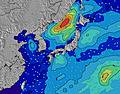 |  |  |  |  | |||||||||||
Oleaje Altura (m) Dirección Período (s) | E 16 | E 16 | E 16 | E 16 | E 17 | E 17 | E 17 | E 17 | E 17 | E 17 | E 17 | E 17 | E 17 | E 17 | E 17 | E 18 | E 18 | E 18 |
Gráfico Olas | ||||||||||||||||||
1438 | 1452 | 1626 | 1652 | 2353 | 2873 | 2840 | 3104 | 3710 | 4328 | 4941 | 4088 | 4544 | 5705 | 7747 | 10244 | 14374 | 17849 | |
Viento (km/h) | ||||||||||||||||||
Estado del Viento Viento de Mar Viento de Mar-Cruzado Cruzado Viento de Tierra-Cruzado Viento de Tierra Cristalino | cross-on | cross-on | cross-on | on | on | on | on | on | on | cross-on | cross-on | on | on | on | on | on | on | cross-on |
Marea alta | 10:00PM1.76m | 10:14AM1.62m | 10:32PM1.73m | 11:10AM1.50m | ||||||||||||||
Marea baja | 3:40PM0.44m | 4:10AM0.57m | 4:14PM0.59m | 4:58AM0.55m | 4:53PM0.76m | |||||||||||||
— | — | — | 5:52 | — | — | — | — | — | — | — | 5:52 | — | — | — | — | — | — | |
7:14 | — | — | — | — | — | — | — | 7:13 | — | — | — | — | — | — | — | 7:12 | — | |
mm | — | 1 | 2 | — | 2 | 1 | 1 | 1 | 1 | 2 | — | 1 | 2 | 1 | — | 1 | 1 | — |
Temp. °C | 30 | 29 | 29 | 29 | 29 | 30 | 29 | 29 | 29 | 29 | 29 | 29 | 29 | 30 | 30 | 29 | 29 | 29 |
Enfriamiento °C | 32 | 31 | 30 | 31 | 31 | 32 | 30 | 30 | 31 | 30 | 29 | 31 | 30 | 31 | 31 | 29 | 29 | 28 |
Oleaje 1 Altura (m) Dirección Período (s) | E 16 | E 16 | E 16 | E 16 | E 17 | E 17 | E 17 | E 17 | E 17 | E 17 | E 17 | E 17 | E 17 | E 17 | E 17 | E 18 | E 18 | E 18 |
1438 | 1452 | 1626 | 1652 | 2353 | 2873 | 2840 | 3104 | 3710 | 4328 | 4941 | 4088 | 4544 | 5705 | 7747 | 10244 | 14374 | 17849 | |
Oleaje 2 Altura (m) Dirección Período (s) | S 7 | SE 14 | S 7 | S 7 | SE 14 | S 8 | — | SE 8 | — | — | — | — | S 8 | — | S 8 | — | — | — |
9 | 33 | 9 | 9 | 8 | 18 | — | 32 | — | — | — | — | 18 | — | 18 | — | — | — | |
Oleaje 3 Altura (m) Dirección Período (s) | SE 14 | S 7 | SE 8 | SE 8 | — | — | — | — | — | — | — | — | — | — | — | — | — | — |
8 | 4 | 11 | 3 | — | — | — | — | — | — | — | — | — | — | — | — | — | — | |
Olas de Viento Altura (m) Dirección Período (s) | N 4 | N 4 | NNE 4 | NNE 4 | SE 8 | NNE 4 | SE 8 | — | — | — | — | ENE 5 | NE 6 | NE 6 | NE 7 | — | — | — |
11 | 14 | 18 | 17 | 23 | 26 | 21 | — | — | — | — | 47 | 77 | 109 | 179 | — | — | — | |
Viento del Tierra o Mar Limpio más proximo | ||||||||||||||||||
Distancia (km) | 582 | 582 | 41 | 46 | 46 | 46 | 46 | 46 | 46 | 46 | 46 | 46 | 46 | 46 | 869 | 747 | 747 | 675 |
Mejores Olas Previstas en Okinawa | ||||||||||||||||||
Mejores Olas Previstas en Japan | ||||||||||||||||||
Busca-Olas Global | ||||||||||||||||||
- Map Icons:
 Break
Break Live Wave Height (m)
 Live Wind Speed (km/h)
 Surf Rating (10 Max)
 Ocean Swells (m)
- Wind Speed (km/h)
GRÁTIS! Un widget de Surf-Forecast.com para tu sitio
Este widget grátis de previsiones de surf y tiempo puede ser añadido a cualquier otro sitio y da un resumen de previsiones de olas para Ko-Chan (Hedo Point). Solo necesita cortar y pegar el código HTML de abajo en su web. Puede elegir preferencias de idioma y de unidades (métricas o imperiales) para convenir a los usuarios de su sitio. Clica aquí para obtener el código.
 Nearest