
Previsiones:

Pronóstico Corto PlazoMayormente seco. Warm (max 22°C el martes por la mañana, min 16°C el miércoles por la noche). El viento será generalmente ligero. | |||||||||||||||||||||
lun 3 | martes 4 | miércoles 5 | |||||||||||||||||||
10 AM | 1 PM | 4 PM | 7 PM | 10 PM | 1 AM | 4 AM | 7 AM | 10 AM | 1 PM | 4 PM | 7 PM | 10 PM | 1 AM | 4 AM | 7 AM | 10 AM | 1 PM | 4 PM | 7 PM | 10 PM | |
Mapa de Altura de Olas |  |  |  | 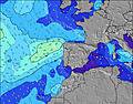 |  |  |  |  | |||||||||||||
Oleaje Altura (m) Dirección Período (s) | W 9 | W 9 | W 8 | W 7 | W 8 | W 8 | W 9 | W 9 | W 9 | W 8 | W 8 | W 8 | W 8 | W 8 | W 8 | NW 10 | W 8 | W 8 | NW 9 | NW 9 | NW 6 |
Gráfico Olas | |||||||||||||||||||||
127 | 153 | 208 | 109 | 137 | 116 | 152 | 123 | 120 | 115 | 109 | 86 | 84 | 86 | 61 | 80 | 58 | 55 | 197 | 307 | 196 | |
Viento (km/h) | |||||||||||||||||||||
Estado del Viento Viento de Mar Viento de Mar-Cruzado Cruzado Viento de Tierra-Cruzado Viento de Tierra Cristalino | cross | cross-on | cross-on | on | glassy | glassy | cross-off | cross-off | cross | cross-on | on | cross-on | cross-off | cross-off | cross-off | cross-off | cross | cross | cross | cross | cross-off |
Marea alta | 6:45PM3.29m | 7:12AM3.12m | 7:29PM3.16m | 8:01AM3.03m | 8:22PM2.99m | ||||||||||||||||
Marea baja | 12:30PM0.78m | 00:57AM0.73m | 1:14PM0.89m | 1:42AM0.85m | 2:06PM1.03m | ||||||||||||||||
6:31 | — | — | — | — | — | 6:31 | — | — | — | — | — | — | — | 6:33 | — | — | — | — | — | — | |
— | — | — | 8:51 | — | — | — | — | — | — | — | 8:50 | — | — | — | — | — | — | — | 8:49 | — | |
mm | — | — | — | — | — | — | — | — | — | — | — | — | — | — | — | — | — | — | — | — | — |
Temp. °C | 21 | 21 | 20 | 21 | 19 | 19 | 18 | 18 | 21 | 22 | 22 | 22 | 20 | 19 | 18 | 17 | 20 | 22 | 21 | 20 | 19 |
Enfriamiento °C | 20 | 20 | 20 | 23 | 21 | 21 | 19 | 19 | 22 | 22 | 23 | 23 | 21 | 19 | 18 | 17 | 19 | 19 | 17 | 16 | 17 |
Oleaje 1 Altura (m) Dirección Período (s) | W 9 | W 9 | W 8 | W 7 | W 8 | W 8 | W 9 | W 9 | W 9 | W 8 | W 8 | W 8 | W 8 | W 8 | W 8 | W 8 | W 8 | NW 9 | W 7 | WNW 10 | WNW 10 |
127 | 153 | 208 | 109 | 137 | 116 | 152 | 123 | 120 | 115 | 109 | 86 | 84 | 86 | 61 | 61 | 58 | 84 | 26 | 35 | 34 | |
Oleaje 2 Altura (m) Dirección Período (s) | NNW 8 | NNW 8 | NW 8 | W 9 | NW 8 | N 8 | NW 9 | NNW 9 | NW 11 | NW 11 | NW 11 | NNW 11 | NW 10 | NW 11 | NNW 11 | NW 10 | NW 10 | W 8 | WNW 10 | W 7 | SW 12 |
6 | 6 | 2 | 56 | 2 | 1 | 3 | 8 | 5 | 19 | 30 | 45 | 51 | 55 | 76 | 80 | 96 | 55 | 35 | 16 | 6 | |
Oleaje 3 Altura (m) Dirección Período (s) | SW 15 | SW 15 | S 15 | NW 8 | S 14 | SW 14 | SW 13 | NW 11 | N 9 | NNW 9 | N 9 | W 11 | SW 13 | SW 13 | WNW 10 | WNW 10 | W 10 | WNW 10 | SW 12 | SW 12 | — |
8 | 8 | 4 | 2 | 4 | 7 | 7 | 5 | 6 | 8 | 6 | 10 | 7 | 7 | 31 | 33 | 18 | 20 | 6 | 6 | — | |
Olas de Viento Altura (m) Dirección Período (s) | SSE 2 | S 3 | — | — | — | — | — | — | — | — | — | — | — | — | — | — | — | NW 3 | NW 9 | NW 9 | NW 6 |
1 | 5 | — | — | — | — | — | — | — | — | — | — | — | — | — | — | — | 3 | 197 | 307 | 196 | |
Viento del Tierra o Mar Limpio más proximo | |||||||||||||||||||||
Distancia (km) | 60 | 101 | 101 | 101 | 4 | 0 | 0 | 0 | 101 | 101 | 101 | 316 | 0 | 0 | 0 | 0 | 4 | 282 | 248 | 249 | 147 |
Mejores Olas Previstas en Douro and Minho | |||||||||||||||||||||
Mejores Olas Previstas en Portugal | |||||||||||||||||||||
Busca-Olas Global | |||||||||||||||||||||
- Map Icons:
 Break
Break Live Wave Height (m)
 Live Wind Speed (km/h)
 Surf Rating (10 Max)
 Ocean Swells (m)
- Wind Speed (km/h)
GRÁTIS! Un widget de Surf-Forecast.com para tu sitio
Este widget grátis de previsiones de surf y tiempo puede ser añadido a cualquier otro sitio y da un resumen de previsiones de olas para Kings Rock. Solo necesita cortar y pegar el código HTML de abajo en su web. Puede elegir preferencias de idioma y de unidades (métricas o imperiales) para convenir a los usuarios de su sitio. Clica aquí para obtener el código.
 Nearest