
Previsiones:

Pronóstico Corto PlazoMayormente seco. Warm (max 30°C el lunes por la tarde, min 27°C el lunes por la noche). El viento será generalmente ligero. | |||||||||||||||||||||||
lunes 3 | martes 4 | miércoles 5 | |||||||||||||||||||||
5 AM | 8 AM | 11 AM | 2 PM | 5 PM | 8 PM | 11 PM | 2 AM | 5 AM | 8 AM | 11 AM | 2 PM | 5 PM | 8 PM | 11 PM | 2 AM | 5 AM | 8 AM | 11 AM | 2 PM | 5 PM | 8 PM | 11 PM | |
Mapa de Altura de Olas | 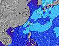 | 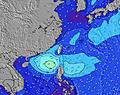 | 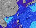 | 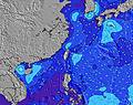 | 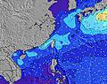 | 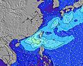 | 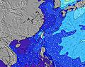 | 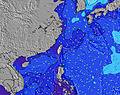 | 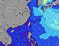 | ||||||||||||||
Oleaje Altura (m) Dirección Período (s) | E 17 | E 18 | E 15 | E 16 | E 16 | E 16 | E 16 | E 16 | E 16 | E 16 | E 16 | E 16 | E 16 | E 17 | E 18 | E 18 | E 18 | E 18 | E 17 | E 17 | E 17 | E 17 | ENE 18 |
Gráfico Olas | |||||||||||||||||||||||
214 | 294 | 225 | 313 | 412 | 427 | 483 | 705 | 719 | 853 | 822 | 952 | 1106 | 1359 | 1561 | 1759 | 1759 | 1970 | 2196 | 2146 | 2072 | 2248 | 2611 | |
Viento (km/h) | |||||||||||||||||||||||
Estado del Viento Viento de Mar Viento de Mar-Cruzado Cruzado Viento de Tierra-Cruzado Viento de Tierra Cristalino | cross-off | cross | cross | cross | cross-off | cross | cross-off | cross-off | cross | cross | cross | cross-off | glassy | cross | cross | cross-off | off | off | cross-off | cross-off | off | off | glassy |
Marea alta | 9:16AM0.99m | 10:03PM0.79m | 9:57AM0.86m | 10:43PM0.86m | 10:48AM0.72m | ||||||||||||||||||
Marea baja | 2:49AM0.36m | 3:56PM0.26m | 3:48AM0.37m | 4:18PM0.31m | 5:01AM0.38m | 4:40PM0.37m | |||||||||||||||||
5:28 | — | — | — | — | — | — | — | 5:30 | — | — | — | — | — | — | — | 5:30 | — | — | — | — | — | — | |
— | — | — | — | 6:36 | — | — | — | — | — | — | — | 6:35 | — | — | — | — | — | — | — | 6:35 | — | — | |
mm | — | — | — | — | — | — | — | — | — | — | — | — | — | — | — | — | — | — | — | — | — | — | — |
Temp. °C | 28 | 28 | 29 | 30 | 29 | 28 | 27 | 27 | 27 | 28 | 29 | 30 | 29 | 28 | 28 | 27 | 27 | 28 | 29 | 29 | 29 | 29 | 28 |
Enfriamiento °C | 32 | 31 | 31 | 32 | 32 | 31 | 30 | 30 | 30 | 30 | 31 | 34 | 33 | 32 | 32 | 30 | 29 | 32 | 33 | 32 | 32 | 34 | 33 |
Oleaje 1 Altura (m) Dirección Período (s) | SW 7 | E 18 | E 15 | E 16 | E 16 | E 16 | E 16 | E 16 | E 16 | E 16 | E 16 | E 16 | E 16 | E 17 | E 18 | E 18 | E 18 | E 18 | E 17 | E 17 | E 17 | E 17 | ENE 18 |
42 | 294 | 225 | 313 | 412 | 427 | 483 | 705 | 719 | 853 | 822 | 952 | 1106 | 1359 | 1561 | 1759 | 1759 | 1970 | 2196 | 2146 | 2072 | 2248 | 2611 | |
Oleaje 2 Altura (m) Dirección Período (s) | E 17 | WSW 7 | WSW 7 | WSW 7 | SW 7 | SW 7 | SW 7 | E 6 | E 6 | E 6 | WSW 7 | SW 7 | SW 7 | SW 7 | ESE 6 | ESE 6 | ESE 6 | SW 7 | SW 6 | WSW 6 | NE 18 | NE 18 | NE 19 |
214 | 34 | 35 | 36 | 26 | 25 | 25 | 57 | 47 | 47 | 19 | 12 | 12 | 12 | 37 | 18 | 12 | 11 | 11 | 16 | 12 | 13 | 55 | |
Oleaje 3 Altura (m) Dirección Período (s) | E 6 | E 9 | SE 9 | SE 9 | E 8 | E 8 | E 9 | WSW 7 | WSW 7 | WSW 7 | E 8 | SE 8 | E 8 | SW 7 | SW 7 | SW 7 | SW 7 | — | — | NE 18 | — | — | — |
24 | 6 | 3 | 3 | 6 | 6 | 6 | 19 | 19 | 18 | 6 | 9 | 12 | 12 | 12 | 11 | 11 | — | — | 13 | — | — | — | |
Olas de Viento Altura (m) Dirección Período (s) | NNE 3 | E 6 | E 6 | E 5 | E 6 | E 6 | E 6 | NNE 4 | E 6 | ENE 6 | E 6 | E 6 | E 6 | ESE 6 | E 5 | — | — | — | — | WSW 6 | W 6 | WSW 7 | WSW 7 |
1 | 36 | 60 | 56 | 60 | 64 | 71 | 11 | 60 | 60 | 58 | 40 | 44 | 50 | 19 | — | — | — | — | 14 | 22 | 17 | 17 | |
Viento del Tierra o Mar Limpio más proximo | |||||||||||||||||||||||
Distancia (km) | 0 | 318 | 675 | 675 | 0 | 2 | 0 | 0 | 2 | 318 | 2 | 0 | 0 | 2 | 81 | 0 | 0 | 0 | 0 | 0 | 0 | 0 | 0 |
Mejores Olas Previstas en South Taiwan | |||||||||||||||||||||||
Mejores Olas Previstas en Taiwan | |||||||||||||||||||||||
Busca-Olas Global | |||||||||||||||||||||||
- Map Icons:
 Break
Break Live Wave Height (m)
 Live Wind Speed (km/h)
 Surf Rating (10 Max)
 Ocean Swells (m)
- Wind Speed (km/h)
GRÁTIS! Un widget de Surf-Forecast.com para tu sitio
Este widget grátis de previsiones de surf y tiempo puede ser añadido a cualquier otro sitio y da un resumen de previsiones de olas para Kenting. Solo necesita cortar y pegar el código HTML de abajo en su web. Puede elegir preferencias de idioma y de unidades (métricas o imperiales) para convenir a los usuarios de su sitio. Clica aquí para obtener el código.
 Nearest