
Previsiones:

Pronóstico Corto PlazoFuerte lluvia (totál 23mm), más pesada durante la mañana de lunes. Warm (max 30°C el martes por la tarde, min 18°C el lunes por la noche). Vientos decreciente (vientos frescos desde el S el lunes por la mañana, calma por la mañana de miércoles). | |||||||||||||||||||||||
lunes 3 | martes 4 | miércoles 5 | |||||||||||||||||||||
5 AM | 8 AM | 11 AM | 2 PM | 5 PM | 8 PM | 11 PM | 2 AM | 5 AM | 8 AM | 11 AM | 2 PM | 5 PM | 8 PM | 11 PM | 2 AM | 5 AM | 8 AM | 11 AM | 2 PM | 5 PM | 8 PM | 11 PM | |
Mapa de Altura de Olas | 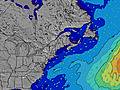 | 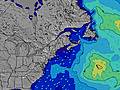 | 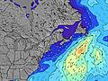 | 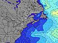 | 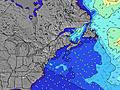 | 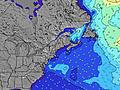 | 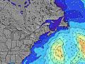 | 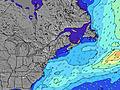 | 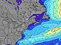 | ||||||||||||||
Oleaje Altura (m) Dirección Período (s) | SSE 4 | SSE 5 | SSE 6 | SSE 6 | SSE 8 | SSE 8 | W 4 | SSE 8 | SSE 8 | SSE 8 | SSE 8 | SSE 8 | S 8 | SSE 5 | S 5 | S 5 | SSE 7 | SSE 7 | SSE 7 | SSE 7 | SSE 7 | SSE 7 | SSE 6 |
Gráfico Olas | |||||||||||||||||||||||
22 | 42 | 136 | 226 | 640 | 0 | 14 | 273 | 176 | 96 | 73 | 54 | 0 | 37 | 54 | 40 | 31 | 41 | 31 | 31 | 30 | 29 | 37 | |
Viento (km/h) | |||||||||||||||||||||||
Estado del Viento Viento de Mar Viento de Mar-Cruzado Cruzado Viento de Tierra-Cruzado Viento de Tierra Cristalino | cross-on | cross-on | cross-on | cross-on | cross-on | on | cross-on | cross-on | cross-on | cross-on | cross-on | on | on | on | on | cross-on | glassy | glassy | cross | cross | cross | cross | cross-on |
Marea alta | 2:46AM2.80m | 3:13PM2.78m | 3:30AM2.73m | 3:55PM2.85m | 4:19AM2.65m | 4:41PM2.90m | |||||||||||||||||
Marea baja | 8:54AM0.08m | 9:17PM0.18m | 9:35AM0.12m | 10:07PM0.15m | 10:21AM0.18m | ||||||||||||||||||
5:33 | — | — | — | — | — | — | — | 5:33 | — | — | — | — | — | — | — | 5:35 | — | — | — | — | — | — | |
— | — | — | — | — | 8:01 | — | — | — | — | — | — | — | 8:00 | — | — | — | — | — | — | 7:59 | — | — | |
mm | 1 | 7 | 5 | 5 | 1 | 5 | — | — | — | — | — | — | — | — | — | — | — | — | — | — | — | — | — |
Temp. °C | 20 | 21 | 22 | 22 | 23 | 21 | 20 | 18 | 19 | 20 | 26 | 29 | 30 | 27 | 25 | 22 | 21 | 20 | 24 | 24 | 23 | 22 | 21 |
Enfriamiento °C | 22 | 22 | 21 | 22 | 22 | 19 | 17 | 15 | 17 | 18 | 24 | 26 | 27 | 25 | 24 | 21 | 21 | 21 | 23 | 25 | 25 | 25 | 23 |
Oleaje 1 Altura (m) Dirección Período (s) | SE 7 | SE 9 | SE 9 | — | — | — | S 8 | SSE 8 | SSE 8 | SSE 8 | SSE 8 | SSE 8 | — | SSE 7 | SSE 5 | SSE 5 | S 5 | SSE 7 | SSE 7 | SSE 7 | SSE 7 | SSE 7 | SSE 6 |
7 | 3 | 3 | — | — | — | 539 | 273 | 176 | 96 | 73 | 54 | — | 20 | 48 | 39 | 17 | 41 | 31 | 31 | 30 | 29 | 37 | |
Oleaje 2 Altura (m) Dirección Período (s) | ESE 9 | — | — | — | — | — | — | — | — | — | — | E 9 | — | — | SSE 8 | SSE 7 | SSE 7 | E 10 | E 10 | E 9 | E 9 | S 9 | S 8 |
8 | — | — | — | — | — | — | — | — | — | — | 2 | — | — | 23 | 20 | 31 | 2 | 2 | 2 | 2 | 1 | 5 | |
Oleaje 3 Altura (m) Dirección Período (s) | S 7 | — | — | — | — | — | — | — | — | — | — | — | — | — | E 10 | E 10 | E 10 | — | — | — | E 9 | E 9 | E 9 |
4 | — | — | — | — | — | — | — | — | — | — | — | — | — | 2 | 2 | 2 | — | — | — | 2 | 2 | 2 | |
Olas de Viento Altura (m) Dirección Período (s) | SSE 4 | SSE 5 | SSE 6 | SSE 6 | SSE 8 | SSE 8 | W 4 | W 4 | W 3 | WSW 3 | WSW 3 | SSW 3 | S 8 | SSE 5 | S 5 | S 5 | — | — | — | — | — | — | — |
22 | 42 | 136 | 226 | 640 | 773 | 14 | 10 | 8 | 6 | 4 | 6 | 115 | 37 | 54 | 40 | — | — | — | — | — | — | — | |
Viento del Tierra o Mar Limpio más proximo | |||||||||||||||||||||||
Distancia (km) | 2023 | 657 | 636 | 431 | 414 | 108 | 11 | 11 | 11 | 11 | 11 | 247 | 49 | 247 | 11 | 11 | 216 | 209 | 209 | 158 | 155 | 163 | 219 |
Mejores Olas Previstas en Maine | |||||||||||||||||||||||
Mejores Olas Previstas en United States | |||||||||||||||||||||||
Busca-Olas Global | |||||||||||||||||||||||
- Map Icons:
 Break
Break Live Wave Height (m)
 Live Wind Speed (km/h)
 Surf Rating (10 Max)
 Ocean Swells (m)
- Wind Speed (km/h)
GRÁTIS! Un widget de Surf-Forecast.com para tu sitio
Este widget grátis de previsiones de surf y tiempo puede ser añadido a cualquier otro sitio y da un resumen de previsiones de olas para Kennebunk Beach. Solo necesita cortar y pegar el código HTML de abajo en su web. Puede elegir preferencias de idioma y de unidades (métricas o imperiales) para convenir a los usuarios de su sitio. Clica aquí para obtener el código.
 Nearest