
Previsiones:

Pronóstico Corto PlazoMayormente seco. Warm (max 28°C el jueves por la mañana, min 22°C el lunes por la noche). El viento será generalmente ligero. | ||||||||||||||||||
lun 3 | martes 4 | miércoles 5 | ||||||||||||||||
6 PM | 9 PM | 12 AM | 3 AM | 6 AM | 9 AM | 12 PM | 3 PM | 6 PM | 9 PM | 12 AM | 3 AM | 6 AM | 9 AM | 12 PM | 3 PM | 6 PM | 9 PM | |
Mapa de Altura de Olas |  |  | 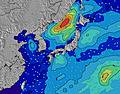 |  |  |  |  | |||||||||||
Oleaje Altura (m) Dirección Período (s) | SE 17 | ESE 17 | ESE 16 | SE 16 | SE 16 | SE 16 | SE 16 | SE 16 | SE 16 | SE 15 | SE 16 | SE 15 | SE 15 | SE 15 | SE 16 | SE 16 | SE 15 | SE 15 |
Gráfico Olas | ||||||||||||||||||
2748 | 3808 | 3976 | 3940 | 4451 | 4574 | 4764 | 4888 | 4891 | 4893 | 5292 | 4802 | 4676 | 4668 | 5341 | 4853 | 4099 | 3771 | |
Viento (km/h) | ||||||||||||||||||
Estado del Viento Viento de Mar Viento de Mar-Cruzado Cruzado Viento de Tierra-Cruzado Viento de Tierra Cristalino | cross | cross | cross-off | cross-off | cross-off | cross | cross | cross | cross | cross-off | cross-off | cross-off | cross-off | cross-off | cross | cross | cross | cross-off |
Marea alta | 7:05PM1.35m | 7:11AM1.20m | 7:27PM1.36m | 8:12AM1.10m | 7:50PM1.36m | |||||||||||||
Marea baja | 1:20AM0.55m | 1:08PM0.56m | 2:08AM0.50m | 1:33PM0.72m | ||||||||||||||
— | — | — | 4:48 | — | — | — | — | — | — | — | 4:48 | — | — | — | — | — | — | |
6:40 | — | — | — | — | — | — | — | 6:39 | — | — | — | — | — | — | — | 6:38 | — | |
mm | — | — | — | — | — | — | — | — | — | — | — | — | — | — | — | — | — | — |
Temp. °C | 24 | 23 | 23 | 22 | 22 | 24 | 24 | 24 | 24 | 23 | 23 | 22 | 22 | 23 | 25 | 26 | 26 | 25 |
Enfriamiento °C | 23 | 22 | 22 | 20 | 21 | 21 | 21 | 21 | 22 | 22 | 22 | 21 | 21 | 22 | 25 | 27 | 28 | 28 |
Oleaje 1 Altura (m) Dirección Período (s) | SE 17 | ESE 17 | ESE 16 | SE 16 | SE 16 | SE 16 | SE 16 | SE 16 | SE 16 | SE 15 | SE 16 | SE 15 | SE 15 | SE 15 | SE 16 | SE 16 | SE 15 | SE 15 |
2748 | 3808 | 3976 | 3940 | 4451 | 4574 | 4764 | 4888 | 4891 | 4893 | 5292 | 4802 | 4676 | 4668 | 5341 | 4853 | 4099 | 3771 | |
Oleaje 2 Altura (m) Dirección Período (s) | E 14 | E 14 | E 13 | SE 20 | E 13 | E 13 | E 13 | E 13 | E 13 | E 13 | E 13 | E 13 | E 18 | E 18 | E 18 | E 18 | E 10 | E 17 |
58 | 57 | 56 | 936 | 56 | 87 | 54 | 53 | 53 | 86 | 54 | 85 | 6 | 6 | 6 | 6 | 535 | 24 | |
Oleaje 3 Altura (m) Dirección Período (s) | — | — | — | E 14 | — | — | — | — | — | — | — | — | E 18 | E 18 | — | — | E 18 | E 17 |
— | — | — | 57 | — | — | — | — | — | — | — | — | 25 | 25 | — | — | 24 | 23 | |
Olas de Viento Altura (m) Dirección Período (s) | ENE 7 | ENE 7 | ENE 7 | ENE 7 | ENE 7 | ENE 7 | ENE 7 | ENE 7 | ENE 7 | ENE 7 | ENE 7 | ENE 7 | — | — | — | — | — | — |
121 | 251 | 254 | 273 | 273 | 280 | 387 | 294 | 305 | 294 | 223 | 243 | — | — | — | — | — | — | |
Viento del Tierra o Mar Limpio más proximo | ||||||||||||||||||
Distancia (km) | 230 | 230 | 575 | 230 | 230 | 577 | 230 | 81 | 577 | 577 | 577 | 575 | 575 | 575 | 575 | 81 | 81 | 0 |
Mejores Olas Previstas en Chiba | ||||||||||||||||||
Mejores Olas Previstas en Japan | ||||||||||||||||||
Busca-Olas Global | ||||||||||||||||||
- Map Icons:
 Break
Break Live Wave Height (m)
 Live Wind Speed (km/h)
 Surf Rating (10 Max)
 Ocean Swells (m)
- Wind Speed (km/h)
GRÁTIS! Un widget de Surf-Forecast.com para tu sitio
Este widget grátis de previsiones de surf y tiempo puede ser añadido a cualquier otro sitio y da un resumen de previsiones de olas para Katagai. Solo necesita cortar y pegar el código HTML de abajo en su web. Puede elegir preferencias de idioma y de unidades (métricas o imperiales) para convenir a los usuarios de su sitio. Clica aquí para obtener el código.
 Nearest