
Previsiones:

Pronóstico Corto PlazoFuerte lluvia (totál 79mm), más pesada durante la mañana de martes. Warm (max 30°C el lunes por la tarde, min 28°C el lunes por la noche). Vientos crecientes (Vientos ligeros desde el SSO el lunes por la tarde, vientos frescos desde el SO por la noche de miércoles). | |||||||||||||||||||
lun 3 | martes 4 | miércoles 5 | |||||||||||||||||
4 PM | 7 PM | 10 PM | 1 AM | 4 AM | 7 AM | 10 AM | 1 PM | 4 PM | 7 PM | 10 PM | 1 AM | 4 AM | 7 AM | 10 AM | 1 PM | 4 PM | 7 PM | 10 PM | |
Mapa de Altura de Olas | 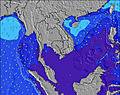 | 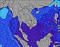 | 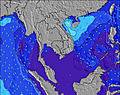 | 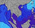 | 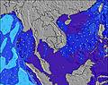 | 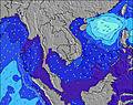 | 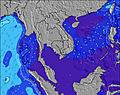 | ||||||||||||
Oleaje Altura (m) Dirección Período (s) | S 4 | SW 15 | WSW 15 | WSW 3 | W 6 | W 7 | WSW 8 | WSW 8 | WSW 8 | WSW 8 | WSW 10 | WSW 10 | WSW 10 | WSW 16 | WSW 16 | WSW 9 | WSW 16 | WSW 16 | WSW 9 |
Gráfico Olas | |||||||||||||||||||
4 | 9 | 22 | 1 | 0 | 0 | 0 | 785 | 682 | 383 | 0 | 0 | 227 | 26 | 26 | 158 | 25 | 25 | 177 | |
Viento (km/h) | |||||||||||||||||||
Estado del Viento Viento de Mar Viento de Mar-Cruzado Cruzado Viento de Tierra-Cruzado Viento de Tierra Cristalino | cross-on | on | on | on | cross-on | cross-on | on | on | on | cross-on | cross-on | on | cross-on | on | on | on | on | on | on |
Marea alta | 1:16AM1.98m | 1:20PM1.94m | 1:54AM1.93m | 1:59PM1.78m | |||||||||||||||
Marea baja | 7:02PM0.13m | 7:18AM0.36m | 7:35PM0.22m | 8:01AM0.47m | 8:14PM0.35m | ||||||||||||||
— | — | — | — | 6:18 | — | — | — | — | — | — | — | 6:18 | — | — | — | — | — | — | |
6:45 | — | — | — | — | — | — | — | 6:45 | — | — | — | — | — | — | — | 6:45 | — | — | |
mm | — | 1 | — | 5 | 3 | 3 | 5 | 6 | 1 | 1 | 3 | 5 | 6 | 5 | 5 | 5 | 4 | 2 | 4 |
Temp. °C | 30 | 29 | 29 | 28 | 28 | 28 | 28 | 28 | 28 | 28 | 28 | 28 | 28 | 28 | 28 | 28 | 28 | 28 | 28 |
Enfriamiento °C | 32 | 31 | 32 | 29 | 29 | 30 | 30 | 29 | 28 | 29 | 27 | 26 | 27 | 27 | 27 | 27 | 27 | 27 | 26 |
Oleaje 1 Altura (m) Dirección Período (s) | W 9 | W 10 | W 9 | W 9 | SE 4 | WSW 11 | — | — | W 18 | W 10 | SSE 5 | SSE 5 | W 10 | W 8 | W 8 | W 8 | W 9 | W 9 | W 9 |
43 | 65 | 60 | 56 | 1 | 43 | — | — | 6 | 216 | 8 | 5 | 509 | 343 | 422 | 375 | 384 | 412 | 421 | |
Oleaje 2 Altura (m) Dirección Período (s) | W 15 | SW 15 | WSW 15 | SSE 4 | — | — | — | — | SW 17 | SSE 5 | W 17 | W 17 | SSE 5 | W 10 | WSW 16 | WSW 16 | WSW 16 | WSW 16 | WSW 16 |
17 | 9 | 22 | 2 | — | — | — | — | 11 | 10 | 5 | 5 | 5 | 130 | 26 | 26 | 25 | 25 | 25 | |
Oleaje 3 Altura (m) Dirección Período (s) | — | W 15 | W 15 | W 15 | — | W 18 | — | — | — | — | — | — | WSW 16 | WSW 16 | — | — | — | — | — |
— | 4 | 4 | 4 | — | 6 | — | — | — | — | — | — | 26 | 26 | — | — | — | — | — | |
Olas de Viento Altura (m) Dirección Período (s) | S 4 | S 4 | SSW 4 | WSW 3 | W 6 | W 7 | WSW 8 | WSW 8 | WSW 8 | WSW 8 | WSW 10 | WSW 10 | WSW 10 | SSE 5 | SSE 4 | WSW 9 | — | S 3 | WSW 9 |
4 | 4 | 4 | 1 | 167 | 358 | 533 | 785 | 682 | 383 | 610 | 555 | 227 | 5 | 4 | 158 | — | 1 | 177 | |
Viento del Tierra o Mar Limpio más proximo | |||||||||||||||||||
Distancia (km) | 1 | 19 | 19 | 19 | 1 | 1 | 19 | 646 | 84 | 19 | 604 | 802 | 802 | 691 | 787 | 802 | 802 | 802 | 604 |
Mejores Olas Previstas en Phuket | |||||||||||||||||||
Mejores Olas Previstas en Thailand | |||||||||||||||||||
Busca-Olas Global | |||||||||||||||||||
- Map Icons:
 Break
Break Live Wave Height (m)
 Live Wind Speed (km/h)
 Surf Rating (10 Max)
 Ocean Swells (m)
- Wind Speed (km/h)
GRÁTIS! Un widget de Surf-Forecast.com para tu sitio
Este widget grátis de previsiones de surf y tiempo puede ser añadido a cualquier otro sitio y da un resumen de previsiones de olas para Kata Beach. Solo necesita cortar y pegar el código HTML de abajo en su web. Puede elegir preferencias de idioma y de unidades (métricas o imperiales) para convenir a los usuarios de su sitio. Clica aquí para obtener el código.
 Nearest