
Previsiones:

Pronóstico Corto PlazoLluvia moderada (totál 15mm), más pesada el martes por la tarde. Warm (max 28°C el miércoles por la tarde, min 19°C el jueves por la mañana). Vientos decreciente (vientos frescos desde el SSO el martes por la noche, calma por la noche de jueves). | ||||||||||||||||||||||||
martes 21 | miércoles 22 | jueves 23 | ||||||||||||||||||||||
2 AM | 5 AM | 8 AM | 11 AM | 2 PM | 5 PM | 8 PM | 11 PM | 2 AM | 5 AM | 8 AM | 11 AM | 2 PM | 5 PM | 8 PM | 11 PM | 2 AM | 5 AM | 8 AM | 11 AM | 2 PM | 5 PM | 8 PM | 11 PM | |
Mapa de Altura de Olas | 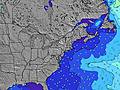 | 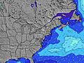 |  | 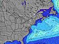 | 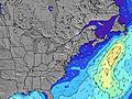 |  | 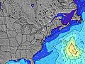 |  |  | |||||||||||||||
Oleaje Altura (m) Dirección Período (s) | S 4 | S 4 | SSE 5 | SSE 5 | SSE 6 | SSE 5 | S 6 | S 6 | S 7 | S 8 | S 8 | S 8 | S 9 | S 8 | S 8 | S 9 | S 9 | SSE 8 | SSE 8 | SSE 8 | SSE 8 | SSE 8 | SSE 8 | S 8 |
Gráfico Olas | ||||||||||||||||||||||||
13 | 25 | 37 | 70 | 98 | 102 | 91 | 113 | 134 | 187 | 501 | 219 | 247 | 177 | 147 | 153 | 154 | 122 | 116 | 89 | 92 | 75 | 71 | 45 | |
Viento (km/h) | ||||||||||||||||||||||||
Estado del Viento Viento de Mar Viento de Mar-Cruzado Cruzado Viento de Tierra-Cruzado Viento de Tierra Cristalino | on | on | on | cross-on | on | on | cross-on | cross-on | cross-on | cross-on | cross-on | cross-on | cross | cross-on | cross | off | off | cross-off | cross-off | cross-off | cross | on | cross-on | on |
Marea alta | 1:19AM1.32m | 1:58PM1.48m | 2:09AM1.22m | 2:47PM1.45m | 3:02AM1.15m | 3:38PM1.44m | ||||||||||||||||||
Marea baja | 7:32AM0.16m | 8:19PM0.30m | 8:25AM0.23m | 9:20PM0.31m | 9:20AM0.27m | 10:16PM0.29m | ||||||||||||||||||
— | 5:41 | — | — | — | — | — | — | — | 5:41 | — | — | — | — | — | — | — | 5:43 | — | — | — | — | — | — | |
— | — | — | — | — | — | 8:20 | — | — | — | — | — | — | — | 8:19 | — | — | — | — | — | — | — | 8:19 | — | |
mm | — | — | — | 3 | 3 | 4 | 4 | — | — | 1 | — | — | — | — | — | — | — | — | — | — | — | — | — | — |
Temp. °C | 23 | 23 | 23 | 24 | 26 | 26 | 23 | 23 | 23 | 23 | 22 | 25 | 27 | 28 | 28 | 23 | 21 | 20 | 19 | 21 | 24 | 23 | 22 | 22 |
Enfriamiento °C | 21 | 21 | 21 | 22 | 26 | 25 | 21 | 21 | 21 | 22 | 20 | 25 | 25 | 26 | 25 | 18 | 17 | 17 | 15 | 17 | 21 | 20 | 19 | 20 |
Oleaje 1 Altura (m) Dirección Período (s) | SE 8 | SE 8 | E 12 | — | — | S 12 | — | — | — | — | S 8 | S 8 | S 9 | S 8 | S 8 | S 9 | S 9 | SSE 8 | SSE 8 | SSE 8 | SSE 8 | SSE 8 | SSE 8 | S 8 |
3 | 3 | 3 | — | — | 3 | — | — | — | — | 241 | 219 | 247 | 177 | 147 | 153 | 154 | 122 | 116 | 89 | 92 | 75 | 71 | 45 | |
Oleaje 2 Altura (m) Dirección Período (s) | S 12 | S 12 | — | — | — | — | — | — | — | — | — | — | — | — | — | — | — | — | — | — | — | E 4 | E 4 | SE 8 |
3 | 3 | — | — | — | — | — | — | — | — | — | — | — | — | — | — | — | — | — | — | — | 4 | 4 | 20 | |
Oleaje 3 Altura (m) Dirección Período (s) | — | — | — | — | — | — | — | — | — | — | — | — | — | — | — | — | — | — | — | — | — | — | — | E 4 |
— | — | — | — | — | — | — | — | — | — | — | — | — | — | — | — | — | — | — | — | — | — | — | 1 | |
Olas de Viento Altura (m) Dirección Período (s) | S 4 | S 4 | SSE 5 | SSE 5 | SSE 6 | SSE 5 | S 6 | S 6 | S 7 | S 8 | S 8 | — | — | W 3 | W 3 | — | NNW 3 | — | NNE 3 | NE 3 | ENE 4 | — | — | — |
13 | 25 | 37 | 70 | 98 | 102 | 91 | 113 | 134 | 187 | 501 | — | — | 3 | 1 | — | 1 | — | 1 | 2 | 3 | — | — | — | |
Viento del Tierra o Mar Limpio más proximo | ||||||||||||||||||||||||
Distancia (km) | 821 | 953 | 953 | 1213 | 1213 | 1213 | 1213 | 289 | 185 | 185 | 182 | 28 | 31 | 47 | 31 | 0 | 0 | 0 | 6 | 0 | 6 | 185 | 185 | 185 |
Mejores Olas Previstas en Long Island New York | ||||||||||||||||||||||||
Mejores Olas Previstas en United States | ||||||||||||||||||||||||
Busca-Olas Global | ||||||||||||||||||||||||
- Map Icons:
 Break
Break Live Wave Height (m)
 Live Wind Speed (km/h)
 Surf Rating (10 Max)
 Ocean Swells (m)
- Wind Speed (km/h)
GRÁTIS! Un widget de Surf-Forecast.com para tu sitio
Este widget grátis de previsiones de surf y tiempo puede ser añadido a cualquier otro sitio y da un resumen de previsiones de olas para Jones Beach. Solo necesita cortar y pegar el código HTML de abajo en su web. Puede elegir preferencias de idioma y de unidades (métricas o imperiales) para convenir a los usuarios de su sitio. Clica aquí para obtener el código.
 Nearest