
Previsiones:

Pronóstico Corto PlazoLluvia ligera (totál 4mm), cayendo mayormente el jueves por la noche. Warm (max 24°C el martes por la mañana, min 22°C el martes por la noche). El viento será generalmente ligero. | ||||||||||||||||||||||
martes 28 | miércoles 29 | jueves 30 | ||||||||||||||||||||
7 AM | 10 AM | 1 PM | 4 PM | 7 PM | 10 PM | 1 AM | 4 AM | 7 AM | 10 AM | 1 PM | 4 PM | 7 PM | 10 PM | 1 AM | 4 AM | 7 AM | 10 AM | 1 PM | 4 PM | 7 PM | 10 PM | |
Mapa de Altura de Olas |  | 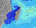 | 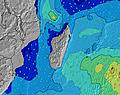 | 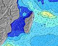 | 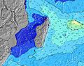 | 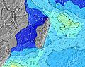 | 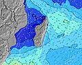 | 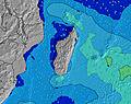 | ||||||||||||||
Oleaje Altura (m) Dirección Período (s) | SW 15 | SW 14 | SSW 19 | SSW 18 | SSW 17 | SSW 16 | SSW 16 | SSW 16 | SSW 15 | SSW 14 | SSW 14 | SSW 14 | SSW 14 | SSW 14 | SSW 14 | SSW 13 | SSW 13 | SSW 13 | SSW 13 | SSW 17 | SSW 16 | SSW 16 |
Gráfico Olas | ||||||||||||||||||||||
543 | 833 | 960 | 2070 | 2196 | 1647 | 1586 | 1743 | 1393 | 1319 | 1114 | 1099 | 969 | 777 | 743 | 634 | 615 | 499 | 421 | 368 | 957 | 957 | |
Viento (km/h) | ||||||||||||||||||||||
Estado del Viento Viento de Mar Viento de Mar-Cruzado Cruzado Viento de Tierra-Cruzado Viento de Tierra Cristalino | cross-off | cross-off | cross-off | cross | cross | cross-off | cross | cross-off | cross-off | cross-off | cross-off | cross-off | cross | cross | cross-off | cross-off | cross-off | cross-off | cross-off | cross-off | cross-off | cross-off |
Marea alta | 12:33PM0.66m | 00:19AM0.78m | 12:58PM0.70m | 00:47AM0.82m | 1:22PM0.74m | |||||||||||||||||
Marea baja | 6:22AM0.08m | 6:16PM0.20m | 6:49AM0.05m | 6:44PM0.17m | 7:14AM0.03m | 7:11PM0.15m | ||||||||||||||||
6:41 | — | — | — | — | — | — | 6:41 | — | — | — | — | — | — | — | 6:39 | — | — | — | — | — | — | |
— | — | — | 5:49 | — | — | — | — | — | — | — | 5:50 | — | — | — | — | — | — | — | 5:50 | — | — | |
mm | — | — | — | — | — | — | — | — | — | — | — | — | — | — | — | — | — | — | — | — | — | — |
Temp. °C | 22 | 23 | 24 | 24 | 23 | 23 | 23 | 22 | 22 | 23 | 23 | 23 | 23 | 23 | 22 | 22 | 22 | 23 | 23 | 23 | 23 | 22 |
Enfriamiento °C | 23 | 23 | 24 | 24 | 23 | 24 | 24 | 23 | 23 | 23 | 23 | 24 | 24 | 25 | 23 | 23 | 23 | 24 | 23 | 23 | 24 | 22 |
Oleaje 1 Altura (m) Dirección Período (s) | SW 15 | SW 14 | SW 14 | SSW 18 | SSW 17 | SSW 16 | SSW 16 | SSW 16 | SSW 15 | SSW 14 | SSW 14 | SSW 14 | SSW 14 | SSW 14 | SSW 14 | SSW 13 | SSW 13 | SSW 13 | SSW 13 | SSW 13 | SSW 16 | SSW 16 |
543 | 833 | 763 | 2070 | 2196 | 1647 | 1586 | 1743 | 1393 | 1319 | 1114 | 1099 | 969 | 777 | 743 | 634 | 615 | 499 | 421 | 341 | 957 | 957 | |
Oleaje 2 Altura (m) Dirección Período (s) | E 10 | E 10 | SSW 19 | E 10 | E 10 | E 10 | E 10 | ESE 11 | ESE 11 | E 10 | E 10 | E 10 | E 10 | E 10 | E 10 | E 9 | E 9 | E 9 | E 9 | E 9 | E 9 | E 8 |
231 | 231 | 960 | 153 | 156 | 156 | 161 | 204 | 196 | 161 | 161 | 158 | 158 | 158 | 148 | 164 | 164 | 164 | 160 | 160 | 157 | 169 | |
Oleaje 3 Altura (m) Dirección Período (s) | SW 12 | SSW 19 | E 10 | SE 11 | SE 12 | ESE 12 | SE 11 | E 10 | E 10 | SE 10 | SE 10 | ESE 10 | ESE 10 | ESE 10 | ESE 10 | ESE 12 | ESE 11 | ESE 11 | ESE 11 | SSW 17 | SE 10 | SE 10 |
228 | 539 | 192 | 121 | 142 | 174 | 176 | 127 | 164 | 160 | 151 | 130 | 133 | 133 | 133 | 169 | 149 | 149 | 146 | 368 | 104 | 102 | |
Olas de Viento Altura (m) Dirección Período (s) | — | — | — | — | — | — | — | — | — | ENE 5 | ENE 5 | — | — | — | — | — | — | — | — | — | — | — |
— | — | — | — | — | — | — | — | — | 21 | 19 | — | — | — | — | — | — | — | — | — | — | — | |
Viento del Tierra o Mar Limpio más proximo | ||||||||||||||||||||||
Distancia (km) | 0 | 0 | 0 | 38 | 38 | 0 | 21 | 0 | 0 | 0 | 38 | 0 | 21 | 21 | 0 | 0 | 0 | 0 | 0 | 0 | 0 | 0 |
Mejores Olas Previstas en Mauritius | ||||||||||||||||||||||
Mejores Olas Previstas en Mauritius | ||||||||||||||||||||||
Busca-Olas Global | ||||||||||||||||||||||
- Map Icons:
 Break
Break Live Wave Height (m)
 Live Wind Speed (km/h)
 Surf Rating (10 Max)
 Ocean Swells (m)
- Wind Speed (km/h)
GRÁTIS! Un widget de Surf-Forecast.com para tu sitio
Este widget grátis de previsiones de surf y tiempo puede ser añadido a cualquier otro sitio y da un resumen de previsiones de olas para Ile des Deux Cocos. Solo necesita cortar y pegar el código HTML de abajo en su web. Puede elegir preferencias de idioma y de unidades (métricas o imperiales) para convenir a los usuarios de su sitio. Clica aquí para obtener el código.
 Nearest