
Previsiones:

Pronóstico Corto PlazoMayormente seco. Very mild (max 17°C el jueves por la mañana, min 13°C el miércoles por la tarde). Vientos crecientes (calma el miércoles por la noche, vientos frescos desde el N por la mañana de sábado). | ||||||||||||||||||||||||
mié 15 | jueves 16 | viernes 17 | sáb 18 | |||||||||||||||||||||
4 PM | 7 PM | 10 PM | 1 AM | 4 AM | 7 AM | 10 AM | 1 PM | 4 PM | 7 PM | 10 PM | 1 AM | 4 AM | 7 AM | 10 AM | 1 PM | 4 PM | 7 PM | 10 PM | 1 AM | 4 AM | 7 AM | 10 AM | 1 PM | |
Mapa de Altura de Olas |  |  |  |  |  |  |  |  | 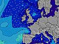 | |||||||||||||||
Oleaje Altura (m) Dirección Período (s) | NNE 6 | NNE 6 | NNE 6 | NNE 6 | NNE 6 | NNE 6 | NNE 6 | NNE 6 | NNE 6 | NNE 6 | NNE 6 | NNE 6 | N 3 | N 3 | N 4 | N 4 | NNE 5 | NNE 5 | NNE 5 | NNE 6 | NNE 6 | NNE 7 | NNE 7 | NNE 8 |
Gráfico Olas | ||||||||||||||||||||||||
22 | 22 | 22 | 15 | 15 | 15 | 14 | 12 | 11 | 10 | 6 | 10 | 3 | 5 | 9 | 20 | 37 | 46 | 62 | 72 | 125 | 227 | 305 | 288 | |
Viento (km/h) | ||||||||||||||||||||||||
Estado del Viento Viento de Mar Viento de Mar-Cruzado Cruzado Viento de Tierra-Cruzado Viento de Tierra Cristalino | on | on | glassy | cross-on | cross-on | cross-on | on | on | on | on | cross-on | cross-on | cross-on | cross-on | cross-on | cross-on | cross-on | cross-on | cross-on | cross-on | cross-on | cross-on | cross-on | cross-on |
Marea alta | 5:12PM4.51m | 5:22AM4.77m | 6:02PM4.49m | 6:09AM4.83m | 6:50PM4.38m | 6:54AM4.76m | ||||||||||||||||||
Marea baja | 11:30PM0.46m | 12:00PM-0.17m | 00:15AM0.49m | 12:46PM-0.17m | 00:58AM0.59m | |||||||||||||||||||
— | — | — | — | 4:48 | — | — | — | — | — | — | — | 4:48 | — | — | — | — | — | — | — | 4:50 | — | — | — | |
— | 9:30 | — | — | — | — | — | — | — | 9:30 | — | — | — | — | — | — | — | 9:29 | — | — | — | — | — | 9:28 | |
mm | — | — | — | — | — | — | — | — | — | — | — | — | — | — | — | — | — | — | — | — | — | — | — | — |
Temp. °C | 14 | 13 | 13 | 13 | 13 | 13 | 15 | 17 | 16 | 16 | 14 | 13 | 13 | 13 | 15 | 15 | 15 | 14 | 13 | 13 | 13 | 13 | 13 | 14 |
Enfriamiento °C | 12 | 11 | 13 | 13 | 13 | 12 | 14 | 16 | 14 | 15 | 13 | 12 | 11 | 10 | 11 | 11 | 11 | 11 | 10 | 11 | 10 | 8 | 7 | 9 |
Oleaje 1 Altura (m) Dirección Período (s) | NNE 6 | NNE 6 | NNE 6 | NNE 6 | NNE 6 | NNE 6 | NNE 6 | NNE 6 | NNE 6 | NNE 6 | NNE 6 | — | NNE 5 | — | — | — | — | — | — | — | — | — | — | — |
22 | 22 | 22 | 15 | 15 | 15 | 14 | 12 | 11 | 10 | 6 | — | 3 | — | — | — | — | — | — | — | — | — | — | — | |
Oleaje 2 Altura (m) Dirección Período (s) | E 4 | E 4 | E 4 | E 4 | E 4 | E 4 | E 4 | E 4 | E 4 | — | — | — | — | — | — | — | — | — | — | — | — | — | — | — |
3 | 3 | 3 | 1 | 1 | 1 | 1 | 1 | 1 | — | — | — | — | — | — | — | — | — | — | — | — | — | — | — | |
Oleaje 3 Altura (m) Dirección Período (s) | — | — | — | — | — | — | — | — | — | — | — | — | — | — | — | — | — | — | — | — | — | — | — | — |
— | — | — | — | — | — | — | — | — | — | — | — | — | — | — | — | — | — | — | — | — | — | — | — | |
Olas de Viento Altura (m) Dirección Período (s) | — | — | — | — | — | — | — | — | — | — | — | NNE 6 | N 3 | N 3 | N 4 | N 4 | NNE 5 | NNE 5 | NNE 5 | NNE 6 | NNE 6 | NNE 7 | NNE 7 | NNE 8 |
— | — | — | — | — | — | — | — | — | — | — | 10 | 3 | 5 | 9 | 20 | 37 | 46 | 62 | 72 | 125 | 227 | 305 | 288 | |
Viento del Tierra o Mar Limpio más proximo | ||||||||||||||||||||||||
Distancia (km) | 427 | 481 | 431 | 478 | 500 | 546 | 489 | 412 | 417 | 431 | 431 | 431 | 438 | 474 | 503 | 1540 | 1540 | 1540 | 62 | 58 | 20 | 56 | 56 | 56 |
Mejores Olas Previstas en North East England | ||||||||||||||||||||||||
Mejores Olas Previstas en United Kingdom | ||||||||||||||||||||||||
Busca-Olas Global | ||||||||||||||||||||||||
- Map Icons:
 Break
Break Live Wave Height (m)
 Live Wind Speed (km/h)
 Surf Rating (10 Max)
 Ocean Swells (m)
- Wind Speed (km/h)
GRÁTIS! Un widget de Surf-Forecast.com para tu sitio
Este widget grátis de previsiones de surf y tiempo puede ser añadido a cualquier otro sitio y da un resumen de previsiones de olas para Huntcliff. Solo necesita cortar y pegar el código HTML de abajo en su web. Puede elegir preferencias de idioma y de unidades (métricas o imperiales) para convenir a los usuarios de su sitio. Clica aquí para obtener el código.
 Nearest