
Previsiones:

Pronóstico Corto PlazoLluvia ligera (totál 8mm), cayendo mayormente el jueves por la tarde. Very mild (max 15°C el miércoles por la tarde, min 12°C el miércoles por la mañana). El viento será generalmente ligero. | ||||||||||||||||||||||||
miércoles 15 | jueves 16 | viernes 17 | sáb 18 | |||||||||||||||||||||
8 AM | 11 AM | 2 PM | 5 PM | 8 PM | 11 PM | 2 AM | 5 AM | 8 AM | 11 AM | 2 PM | 5 PM | 8 PM | 11 PM | 2 AM | 5 AM | 8 AM | 11 AM | 2 PM | 5 PM | 8 PM | 11 PM | 2 AM | 5 AM | |
Mapa de Altura de Olas |  | 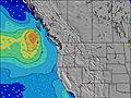 | 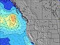 | 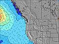 | 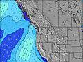 | 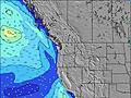 | 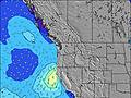 | 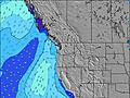 | 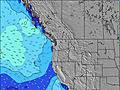 | |||||||||||||||
Oleaje Altura (m) Dirección Período (s) | W 10 | W 20 | SW 18 | SW 18 | W 20 | W 19 | W 19 | W 19 | W 19 | W 19 | W 18 | W 18 | W 17 | W 17 | W 17 | W 17 | W 17 | W 16 | W 16 | W 16 | WNW 11 | W 16 | W 16 | W 16 |
Gráfico Olas | ||||||||||||||||||||||||
122 | 123 | 152 | 152 | 186 | 177 | 173 | 175 | 179 | 255 | 229 | 219 | 211 | 278 | 288 | 288 | 368 | 258 | 252 | 249 | 297 | 265 | 250 | 250 | |
Viento (km/h) | ||||||||||||||||||||||||
Estado del Viento Viento de Mar Viento de Mar-Cruzado Cruzado Viento de Tierra-Cruzado Viento de Tierra Cristalino | glassy | cross-on | cross-on | on | on | cross-on | glassy | cross | cross-off | cross-off | cross-off | cross-off | cross-off | cross-off | cross-off | cross-off | off | cross-off | cross | cross-on | cross-on | on | on | on |
Marea alta | 2:54PM2.51m | 2:20AM3.05m | 3:37PM2.58m | 3:10AM2.87m | 4:19PM2.61m | 4:01AM2.62m | ||||||||||||||||||
Marea baja | 8:07AM-0.77m | 8:09PM0.64m | 8:52AM-0.68m | 9:01PM0.54m | 9:34AM-0.51m | 9:54PM0.48m | ||||||||||||||||||
5:35 | — | — | — | — | — | — | 5:37 | — | — | — | — | — | — | — | 5:37 | — | — | — | — | — | — | — | 5:39 | |
— | — | — | — | 9:07 | — | — | — | — | — | — | — | 9:06 | — | — | — | — | — | — | — | 9:05 | — | — | 9:05 | |
mm | — | — | — | — | — | — | — | 1 | 2 | 1 | 3 | 1 | — | — | — | — | — | — | — | — | — | — | — | — |
Temp. °C | 12 | 14 | 14 | 15 | 14 | 13 | 13 | 13 | 14 | 14 | 14 | 15 | 15 | 15 | 14 | 14 | 14 | 15 | 15 | 15 | 15 | 14 | 14 | 13 |
Enfriamiento °C | 12 | 13 | 11 | 12 | 12 | 12 | 13 | 13 | 13 | 12 | 12 | 14 | 13 | 13 | 12 | 12 | 12 | 13 | 13 | 13 | 13 | 13 | 14 | 13 |
Oleaje 1 Altura (m) Dirección Período (s) | W 10 | W 9 | W 9 | WNW 9 | WNW 9 | WNW 9 | WNW 8 | WNW 8 | WNW 8 | WNW 8 | WNW 8 | WNW 8 | WNW 8 | WNW 8 | WNW 8 | WNW 8 | W 8 | W 8 | WNW 8 | WNW 7 | WNW 11 | WNW 10 | WNW 10 | WNW 10 |
122 | 113 | 136 | 108 | 106 | 101 | 94 | 90 | 87 | 83 | 77 | 94 | 81 | 102 | 105 | 107 | 121 | 118 | 94 | 73 | 297 | 265 | 250 | 250 | |
Oleaje 2 Altura (m) Dirección Período (s) | SW 18 | WSW 18 | SW 18 | SW 18 | SW 18 | W 19 | W 19 | W 19 | W 19 | W 19 | W 18 | W 18 | W 17 | W 17 | W 17 | W 17 | W 17 | W 16 | W 16 | W 16 | W 16 | W 16 | W 16 | W 16 |
80 | 121 | 152 | 152 | 152 | 177 | 173 | 175 | 179 | 255 | 229 | 219 | 211 | 278 | 288 | 288 | 368 | 258 | 252 | 249 | 246 | 246 | 243 | 248 | |
Oleaje 3 Altura (m) Dirección Período (s) | W 13 | W 20 | W 20 | W 19 | W 20 | WSW 18 | SW 17 | SW 17 | WSW 16 | SW 16 | WSW 16 | WSW 16 | SW 16 | SW 16 | SW 16 | SW 16 | SW 16 | SW 16 | W 12 | WNW 11 | SW 19 | SW 19 | SW 19 | SW 14 |
55 | 123 | 125 | 118 | 186 | 120 | 77 | 70 | 104 | 66 | 100 | 100 | 125 | 125 | 124 | 124 | 122 | 122 | 67 | 126 | 181 | 181 | 129 | 54 | |
Olas de Viento Altura (m) Dirección Período (s) | — | — | — | — | — | — | — | — | — | — | SSW 2 | — | SSW 3 | S 3 | S 3 | S 3 | — | — | — | — | — | — | — | — |
— | — | — | — | — | — | — | — | — | — | 1 | — | 1 | 2 | 1 | 2 | — | — | — | — | — | — | — | — | |
Viento del Tierra o Mar Limpio más proximo | ||||||||||||||||||||||||
Distancia (km) | 0 | 167 | 1120 | 1119 | 4 | 4 | 0 | 0 | 0 | 0 | 0 | 0 | 0 | 0 | 0 | 0 | 0 | 0 | 1 | 366 | 52 | 38 | 38 | 1 |
Mejores Olas Previstas en Washington State | ||||||||||||||||||||||||
Mejores Olas Previstas en United States | ||||||||||||||||||||||||
Busca-Olas Global | ||||||||||||||||||||||||
- Map Icons:
 Break
Break Live Wave Height (m)
 Live Wind Speed (km/h)
 Surf Rating (10 Max)
 Ocean Swells (m)
- Wind Speed (km/h)
GRÁTIS! Un widget de Surf-Forecast.com para tu sitio
Este widget grátis de previsiones de surf y tiempo puede ser añadido a cualquier otro sitio y da un resumen de previsiones de olas para Half Moon Bay. Solo necesita cortar y pegar el código HTML de abajo en su web. Puede elegir preferencias de idioma y de unidades (métricas o imperiales) para convenir a los usuarios de su sitio. Clica aquí para obtener el código.
 Nearest