
Previsiones:

Pronóstico Corto PlazoLluvia ligera (totál 3mm), cayendo mayormente el lunes por la mañana. Warm (max 27°C el domingo por la tarde, min 26°C el miércoles por la mañana). Mayormente vientos frescos. | |||||||||||||||||||||
dom 26 | lunes 27 | martes 28 | |||||||||||||||||||
11 AM | 2 PM | 5 PM | 8 PM | 11 PM | 2 AM | 5 AM | 8 AM | 11 AM | 2 PM | 5 PM | 8 PM | 11 PM | 2 AM | 5 AM | 8 AM | 11 AM | 2 PM | 5 PM | 8 PM | 11 PM | |
Mapa de Altura de Olas |  |  | 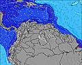 | 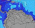 |  | 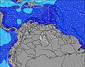 | 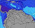 | 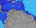 | |||||||||||||
Oleaje Altura (m) Dirección Período (s) | ENE 8 | ENE 8 | ENE 8 | ENE 8 | ENE 8 | ENE 8 | ENE 8 | ENE 8 | ENE 8 | ENE 8 | ENE 8 | ENE 8 | E 8 | E 8 | E 8 | E 8 | E 8 | E 8 | E 8 | E 8 | E 8 |
Gráfico Olas | |||||||||||||||||||||
276 | 266 | 234 | 234 | 204 | 196 | 176 | 155 | 128 | 143 | 143 | 143 | 138 | 138 | 164 | 160 | 135 | 142 | 149 | 161 | 160 | |
Viento (km/h) | |||||||||||||||||||||
Estado del Viento Viento de Mar Viento de Mar-Cruzado Cruzado Viento de Tierra-Cruzado Viento de Tierra Cristalino | on | on | on | on | on | on | on | on | cross-on | on | on | on | on | on | on | on | on | on | on | on | on |
Marea alta | 7:22PM0.33m | 8:01PM0.34m | 8:36PM0.35m | ||||||||||||||||||
Marea baja | 10:37AM0.02m | 11:23AM0.02m | 12:09PM0.03m | ||||||||||||||||||
— | — | — | — | — | — | 5:48 | — | — | — | — | — | — | — | 5:48 | — | — | — | — | — | — | |
— | — | 6:47 | — | — | — | — | — | — | — | 6:47 | — | — | — | — | — | — | — | 6:47 | — | — | |
mm | — | — | — | — | — | — | 1 | — | 2 | — | — | — | — | — | — | — | — | — | — | — | — |
Temp. °C | 27 | 27 | 27 | 27 | 27 | 27 | 27 | 27 | 27 | 27 | 27 | 27 | 27 | 27 | 27 | 27 | 27 | 27 | 27 | 27 | 27 |
Enfriamiento °C | 27 | 27 | 28 | 28 | 28 | 28 | 29 | 29 | 28 | 28 | 28 | 28 | 28 | 27 | 27 | 27 | 27 | 27 | 28 | 28 | 28 |
Oleaje 1 Altura (m) Dirección Período (s) | N 7 | N 7 | N 7 | N 7 | N 7 | ENE 8 | ENE 8 | ENE 8 | ENE 8 | ENE 8 | ESE 9 | ESE 9 | SE 9 | ESE 9 | ESE 9 | ESE 9 | ESE 9 | ESE 9 | ESE 9 | NE 10 | NE 8 |
1 | 1 | 1 | 1 | 1 | 196 | 176 | 155 | 128 | 143 | 8 | 8 | 3 | 8 | 8 | 8 | 8 | 8 | 8 | 4 | 17 | |
Oleaje 2 Altura (m) Dirección Período (s) | — | — | — | — | — | ESE 9 | SE 9 | SE 9 | ESE 9 | ESE 9 | NNE 8 | NE 8 | NE 8 | N 7 | NE 11 | — | — | NE 10 | NE 10 | NE 8 | NE 10 |
— | — | — | — | — | 8 | 3 | 3 | 8 | 8 | 6 | 2 | 2 | 1 | 4 | — | — | 4 | 4 | 10 | 4 | |
Oleaje 3 Altura (m) Dirección Período (s) | — | — | — | — | — | N 7 | N 7 | N 7 | N 7 | N 7 | N 7 | N 7 | N 7 | N 7 | N 7 | N 7 | N 7 | N 7 | N 7 | NE 10 | N 7 |
— | — | — | — | — | 1 | 1 | 1 | 1 | 1 | 1 | 1 | 1 | 1 | 1 | 1 | 1 | 1 | 1 | 15 | 1 | |
Olas de Viento Altura (m) Dirección Período (s) | ENE 8 | ENE 8 | ENE 8 | ENE 8 | ENE 8 | — | — | — | — | — | ENE 8 | ENE 8 | E 8 | E 8 | E 8 | E 8 | E 8 | E 8 | E 8 | E 8 | E 8 |
276 | 266 | 234 | 234 | 204 | — | — | — | — | — | 143 | 143 | 138 | 138 | 164 | 160 | 135 | 142 | 149 | 161 | 160 | |
Viento del Tierra o Mar Limpio más proximo | |||||||||||||||||||||
Distancia (km) | 238 | 166 | 27 | 167 | 162 | 27 | 27 | 25 | 9 | 9 | 27 | 27 | 27 | 313 | 313 | 343 | 432 | 799 | 167 | 167 | 343 |
Mejores Olas Previstas en Netherlands-Antilles - Saint Martin | |||||||||||||||||||||
Mejores Olas Previstas en Netherlands Antilles | |||||||||||||||||||||
Busca-Olas Global | |||||||||||||||||||||
- Map Icons:
 Break
Break Live Wave Height (m)
 Live Wind Speed (km/h)
 Surf Rating (10 Max)
 Ocean Swells (m)
- Wind Speed (km/h)
GRÁTIS! Un widget de Surf-Forecast.com para tu sitio
Este widget grátis de previsiones de surf y tiempo puede ser añadido a cualquier otro sitio y da un resumen de previsiones de olas para Guana Bay. Solo necesita cortar y pegar el código HTML de abajo en su web. Puede elegir preferencias de idioma y de unidades (métricas o imperiales) para convenir a los usuarios de su sitio. Clica aquí para obtener el código.
 Nearest