
Previsiones:

Pronóstico Corto PlazoMayormente seco. Very mild (max 12°C el miércoles por la tarde, min 10°C el lunes por la mañana). Vientos crecientes (Vientos ligeros desde el ONO el martes por la mañana, vientos frescos desde el SSE por la mañana de miércoles). | |||||||||||||||||||||
lun 3 | martes 4 | miércoles 5 | |||||||||||||||||||
9 AM | 12 PM | 3 PM | 6 PM | 9 PM | 12 AM | 3 AM | 6 AM | 9 AM | 12 PM | 3 PM | 6 PM | 9 PM | 12 AM | 3 AM | 6 AM | 9 AM | 12 PM | 3 PM | 6 PM | 9 PM | |
Mapa de Altura de Olas | 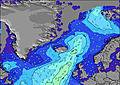 | 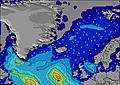 | 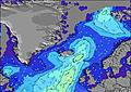 | 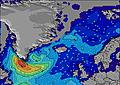 |  | 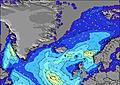 | 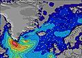 | 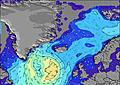 | |||||||||||||
Oleaje Altura (m) Dirección Período (s) | SW 9 | SW 8 | SW 9 | SW 9 | SW 9 | SW 9 | SW 8 | SW 8 | SW 8 | SW 9 | SW 8 | SW 8 | SW 8 | S 9 | SW 9 | WSW 9 | WSW 8 | WSW 8 | WSW 8 | WSW 8 | WSW 9 |
Gráfico Olas | |||||||||||||||||||||
23 | 18 | 21 | 21 | 20 | 19 | 18 | 18 | 18 | 19 | 18 | 17 | 16 | 24 | 21 | 33 | 47 | 73 | 73 | 75 | 116 | |
Viento (km/h) | |||||||||||||||||||||
Estado del Viento Viento de Mar Viento de Mar-Cruzado Cruzado Viento de Tierra-Cruzado Viento de Tierra Cristalino | on | on | on | on | on | cross-on | cross-on | cross-on | cross-on | cross-on | cross-on | cross | cross | cross-off | cross-off | off | off | off | off | off | off |
Marea alta | 9:06AM3.06m | 9:20PM3.15m | 9:44AM2.99m | 9:58PM2.98m | 10:28AM2.88m | ||||||||||||||||
Marea baja | 3:09PM0.38m | 3:33AM0.35m | 3:49PM0.53m | 4:12AM0.48m | 4:35PM0.72m | ||||||||||||||||
4:41 | — | — | — | — | — | 4:45 | — | — | — | — | — | — | — | 4:48 | — | — | — | — | — | — | |
— | — | — | — | 10:28 | — | — | — | — | — | — | — | 10:24 | — | — | — | — | — | — | — | 10:22 | |
mm | — | — | — | — | — | — | — | — | — | — | — | — | — | — | — | — | — | — | — | — | — |
Temp. °C | 10 | 10 | 10 | 11 | 11 | 11 | 11 | 10 | 10 | 10 | 10 | 11 | 10 | 10 | 10 | 10 | 10 | 11 | 11 | 12 | 11 |
Enfriamiento °C | 6 | 6 | 6 | 7 | 7 | 7 | 8 | 7 | 8 | 8 | 7 | 8 | 6 | 6 | 6 | 6 | 4 | 5 | 5 | 7 | 7 |
Oleaje 1 Altura (m) Dirección Período (s) | SSW 9 | SW 7 | SSW 9 | SW 9 | SW 9 | SW 9 | SW 8 | W 5 | W 5 | W 5 | WSW 6 | SW 8 | SW 6 | SW 6 | SW 9 | WSW 9 | WSW 8 | WSW 8 | WSW 8 | WSW 8 | WSW 9 |
15 | 11 | 16 | 21 | 20 | 19 | 18 | 7 | 7 | 7 | 12 | 17 | 8 | 9 | 21 | 33 | 47 | 73 | 73 | 75 | 116 | |
Oleaje 2 Altura (m) Dirección Período (s) | SW 9 | SSW 9 | SW 9 | SSW 9 | S 9 | S 9 | S 8 | SW 8 | SW 8 | SW 9 | SW 8 | WSW 6 | SW 8 | SW 8 | SW 6 | SW 6 | SW 10 | SW 11 | SW 10 | SW 9 | SSE 8 |
23 | 16 | 21 | 15 | 13 | 13 | 13 | 18 | 18 | 19 | 18 | 11 | 16 | 17 | 9 | 12 | 23 | 19 | 25 | 22 | 6 | |
Oleaje 3 Altura (m) Dirección Período (s) | S 18 | SW 8 | WSW 6 | WSW 6 | WSW 6 | WSW 5 | WSW 5 | S 8 | S 8 | SSW 8 | S 8 | S 8 | S 9 | S 9 | S 8 | S 8 | S 10 | SSW 15 | S 15 | S 9 | S 15 |
6 | 18 | 6 | 3 | 3 | 3 | 3 | 12 | 12 | 14 | 13 | 12 | 13 | 24 | 19 | 12 | 17 | 21 | 17 | 7 | 4 | |
Olas de Viento Altura (m) Dirección Período (s) | W 4 | NW 5 | WNW 5 | WNW 5 | WNW 5 | WNW 5 | WNW 5 | WNW 5 | — | — | — | W 5 | — | — | — | — | SSE 4 | S 8 | S 4 | S 4 | S 5 |
9 | 5 | 8 | 8 | 7 | 7 | 8 | 5 | — | — | — | 7 | — | — | — | — | 5 | 64 | 16 | 19 | 11 | |
Viento del Tierra o Mar Limpio más proximo | |||||||||||||||||||||
Distancia (km) | 337 | 1061 | 1184 | 1061 | 1064 | 1061 | 337 | 1121 | 1279 | 1059 | 1059 | 1059 | 1059 | 1059 | 1061 | 32 | 1283 | 1323 | 1353 | 2057 | 0 |
Mejores Olas Previstas en Reykjanes Peninsula | |||||||||||||||||||||
Mejores Olas Previstas en Iceland | |||||||||||||||||||||
Busca-Olas Global | |||||||||||||||||||||
- Map Icons:
 Break
Break Live Wave Height (m)
 Live Wind Speed (km/h)
 Surf Rating (10 Max)
 Ocean Swells (m)
- Wind Speed (km/h)
GRÁTIS! Un widget de Surf-Forecast.com para tu sitio
Este widget grátis de previsiones de surf y tiempo puede ser añadido a cualquier otro sitio y da un resumen de previsiones de olas para Garur. Solo necesita cortar y pegar el código HTML de abajo en su web. Puede elegir preferencias de idioma y de unidades (métricas o imperiales) para convenir a los usuarios de su sitio. Clica aquí para obtener el código.
 Nearest