
Previsiones:

Pronóstico Corto PlazoFuerte lluvia (totál 100mm), más pesada durante la tarde de lunes. Warm (max 28°C el miércoles por la tarde, min 24°C el martes por la tarde). Vientos decreciente (vientos fuertes desde el SSO el martes por la tarde, Vientos ligeros desde el SSO por la mañana de miércoles). | |||||||||||||||||||||||
lunes 3 | martes 4 | miércoles 5 | |||||||||||||||||||||
5 AM | 8 AM | 11 AM | 2 PM | 5 PM | 8 PM | 11 PM | 2 AM | 5 AM | 8 AM | 11 AM | 2 PM | 5 PM | 8 PM | 11 PM | 2 AM | 5 AM | 8 AM | 11 AM | 2 PM | 5 PM | 8 PM | 11 PM | |
Mapa de Altura de Olas |  |  | 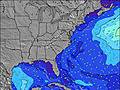 | 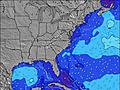 | 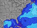 | 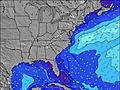 | 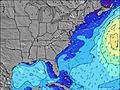 | 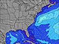 | 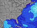 | ||||||||||||||
Oleaje Altura (m) Dirección Período (s) | S 7 | S 7 | S 7 | S 7 | S 7 | S 7 | SSW 7 | SSW 7 | SSW 7 | SSW 7 | SSW 7 | SSW 7 | SSW 6 | SSW 6 | SSW 6 | S 6 | S 6 | S 6 | S 6 | S 6 | S 6 | S 6 | S 6 |
Gráfico Olas | |||||||||||||||||||||||
520 | 461 | 493 | 396 | 302 | 278 | 432 | 512 | 349 | 188 | 132 | 99 | 127 | 121 | 134 | 130 | 108 | 88 | 71 | 85 | 80 | 82 | 74 | |
Viento (km/h) | |||||||||||||||||||||||
Estado del Viento Viento de Mar Viento de Mar-Cruzado Cruzado Viento de Tierra-Cruzado Viento de Tierra Cristalino | cross-on | cross-on | cross-on | cross-on | cross-on | cross-on | cross-on | cross | cross | cross-on | cross-on | cross-on | cross-on | cross-on | cross-on | cross-on | cross-on | cross-on | cross-on | cross-on | cross-on | cross-on | cross-on |
Marea alta | 11:15AM0.96m | 11:25PM0.93m | 12:04PM1.00m | 00:11AM0.86m | 12:58PM1.04m | ||||||||||||||||||
Marea baja | 5:00AM0.02m | 5:22PM0.10m | 5:38AM0.02m | 6:17PM0.13m | 6:22AM0.02m | 7:20PM0.16m | |||||||||||||||||
6:11 | — | — | — | — | — | — | — | 6:13 | — | — | — | — | — | — | — | 6:13 | — | — | — | — | — | — | |
— | — | — | — | — | 8:04 | — | — | — | — | — | — | — | 8:02 | — | — | — | — | — | — | — | 8:01 | — | |
mm | 1 | 4 | 10 | 18 | 3 | 10 | 2 | 2 | 3 | 5 | 6 | 11 | 7 | 3 | 1 | 3 | 2 | 2 | — | 1 | 1 | — | 1 |
Temp. °C | 28 | 26 | 25 | 26 | 25 | 26 | 27 | 26 | 26 | 26 | 25 | 26 | 24 | 25 | 27 | 27 | 27 | 27 | 27 | 27 | 28 | 28 | 27 |
Enfriamiento °C | 26 | 23 | 25 | 24 | 25 | 26 | 25 | 25 | 27 | 27 | 25 | 24 | 21 | 23 | 27 | 26 | 26 | 27 | 27 | 28 | 29 | 29 | 27 |
Oleaje 1 Altura (m) Dirección Período (s) | — | — | — | E 13 | E 13 | E 13 | E 13 | E 13 | SE 7 | SSW 7 | SE 7 | SE 7 | SE 7 | SE 7 | SE 7 | SE 7 | SE 7 | SE 7 | SE 7 | ESE 7 | ESE 7 | SE 7 | SE 7 |
— | — | — | 3 | 3 | 3 | 4 | 3 | 41 | 188 | 55 | 45 | 38 | 48 | 37 | 37 | 49 | 47 | 44 | 33 | 31 | 47 | 23 | |
Oleaje 2 Altura (m) Dirección Período (s) | — | — | — | — | E 13 | E 13 | — | — | E 13 | SE 7 | — | — | — | E 12 | E 12 | E 12 | E 12 | E 12 | E 12 | E 12 | E 12 | E 12 | SE 13 |
— | — | — | — | 3 | 3 | — | — | 4 | 48 | — | — | — | 3 | 3 | 3 | 3 | 3 | 3 | 3 | 3 | 3 | 6 | |
Oleaje 3 Altura (m) Dirección Período (s) | — | — | — | — | — | — | — | — | — | E 14 | — | — | — | — | — | — | E 10 | E 12 | — | N 5 | — | — | — |
— | — | — | — | — | — | — | — | — | 4 | — | — | — | — | — | — | 2 | 3 | — | 1 | — | — | — | |
Olas de Viento Altura (m) Dirección Período (s) | S 7 | S 7 | S 7 | S 7 | S 7 | S 7 | SSW 7 | SSW 7 | SSW 7 | — | SSW 7 | SSW 7 | SSW 6 | SSW 6 | SSW 6 | S 6 | S 6 | S 6 | S 6 | S 6 | S 6 | S 6 | S 6 |
520 | 461 | 493 | 396 | 302 | 278 | 432 | 512 | 349 | — | 132 | 99 | 127 | 121 | 134 | 130 | 108 | 88 | 71 | 85 | 80 | 82 | 74 | |
Viento del Tierra o Mar Limpio más proximo | |||||||||||||||||||||||
Distancia (km) | 1154 | 372 | 190 | 186 | 366 | 301 | 175 | 95 | 74 | 47 | 100 | 243 | 176 | 418 | 622 | 176 | 175 | 175 | 176 | 40 | 100 | 176 | 516 |
Mejores Olas Previstas en North Carolina | |||||||||||||||||||||||
Mejores Olas Previstas en United States | |||||||||||||||||||||||
Busca-Olas Global | |||||||||||||||||||||||
- Map Icons:
 Break
Break Live Wave Height (m)
 Live Wind Speed (km/h)
 Surf Rating (10 Max)
 Ocean Swells (m)
- Wind Speed (km/h)
GRÁTIS! Un widget de Surf-Forecast.com para tu sitio
Este widget grátis de previsiones de surf y tiempo puede ser añadido a cualquier otro sitio y da un resumen de previsiones de olas para Frisco Pier/Cape Hatteras. Solo necesita cortar y pegar el código HTML de abajo en su web. Puede elegir preferencias de idioma y de unidades (métricas o imperiales) para convenir a los usuarios de su sitio. Clica aquí para obtener el código.
 Nearest