
Previsiones:

Pronóstico Corto PlazoLluvia ligera (totál 2mm), cayendo mayormente el martes por la tarde. Very mild (max 13°C el martes por la mañana, min 4°C el miércoles por la noche). El viento será generalmente ligero. | ||||||||||||||||||||||
martes 28 | miércoles 29 | jueves 30 | ||||||||||||||||||||
7 AM | 10 AM | 1 PM | 4 PM | 7 PM | 10 PM | 1 AM | 4 AM | 7 AM | 10 AM | 1 PM | 4 PM | 7 PM | 10 PM | 1 AM | 4 AM | 7 AM | 10 AM | 1 PM | 4 PM | 7 PM | 10 PM | |
Mapa de Altura de Olas |  |  |  | 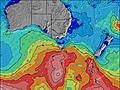 |  |  | 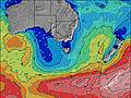 |  | ||||||||||||||
Oleaje Altura (m) Dirección Período (s) | SE 14 | SE 14 | SE 14 | SE 14 | N 7 | N 7 | N 7 | N 7 | N 7 | NNE 7 | SE 13 | SE 13 | S 8 | S 10 | S 10 | S 10 | S 10 | S 10 | S 10 | S 9 | S 9 | S 9 |
Gráfico Olas | ||||||||||||||||||||||
54 | 53 | 52 | 51 | 421 | 274 | 142 | 161 | 107 | 75 | 28 | 46 | 545 | 882 | 654 | 694 | 1330 | 682 | 539 | 739 | 707 | 412 | |
Viento (km/h) | ||||||||||||||||||||||
Estado del Viento Viento de Mar Viento de Mar-Cruzado Cruzado Viento de Tierra-Cruzado Viento de Tierra Cristalino | cross-off | cross-off | cross-off | cross-off | cross-off | cross-off | cross-off | cross-off | off | cross-off | cross-off | cross-off | cross-off | off | off | off | off | off | off | off | cross-off | off |
Marea alta | 8:01AM0.84m | 7:05PM1.27m | 8:39AM0.85m | 7:46PM1.28m | 9:16AM0.88m | 8:26PM1.27m | ||||||||||||||||
Marea baja | 12:38PM0.58m | 2:20AM0.18m | 1:22PM0.57m | 2:57AM0.17m | 2:06PM0.56m | |||||||||||||||||
7:20 | — | — | — | — | — | — | — | 7:18 | — | — | — | — | — | — | — | 7:18 | — | — | — | — | — | |
— | — | — | 5:06 | — | — | — | — | — | — | — | 5:07 | — | — | — | — | — | — | — | 5:07 | — | — | |
mm | — | — | — | — | 1 | 1 | — | — | — | — | — | — | — | — | — | — | — | — | — | — | — | — |
Temp. °C | 11 | 13 | 12 | 12 | 12 | 9 | 5 | 5 | 5 | 9 | 11 | 9 | 7 | 5 | 5 | 5 | 4 | 9 | 11 | 11 | 8 | 5 |
Enfriamiento °C | 6 | 7 | 6 | 7 | 8 | 4 | 1 | 1 | 2 | 5 | 5 | 3 | 2 | 1 | 1 | 1 | 0 | 5 | 7 | 8 | 5 | 2 |
Oleaje 1 Altura (m) Dirección Período (s) | SE 14 | SE 14 | SE 14 | SE 14 | SE 14 | SE 13 | N 7 | SE 13 | N 7 | NNE 7 | N 6 | N 7 | NNE 6 | SE 14 | S 10 | S 10 | S 10 | S 10 | S 10 | S 9 | S 9 | S 9 |
54 | 53 | 52 | 51 | 47 | 28 | 142 | 28 | 107 | 75 | 28 | 14 | 13 | 54 | 654 | 694 | 696 | 682 | 539 | 440 | 422 | 412 | |
Oleaje 2 Altura (m) Dirección Período (s) | S 13 | S 13 | SSE 16 | SSE 15 | S 14 | S 14 | SE 13 | S 16 | SE 13 | S 19 | NNE 9 | NE 6 | SE 14 | NNE 6 | SE 14 | SE 14 | ESE 14 | SE 14 | SE 14 | SE 14 | SE 14 | SE 14 |
14 | 14 | 49 | 42 | 37 | 33 | 28 | 44 | 27 | 63 | 15 | 10 | 52 | 7 | 53 | 52 | 79 | 48 | 46 | 46 | 47 | 47 | |
Oleaje 3 Altura (m) Dirección Período (s) | S 8 | S 16 | S 8 | — | — | — | S 16 | SSW 11 | S 16 | SE 13 | SE 13 | SE 13 | SSW 15 | NE 14 | N 6 | N 6 | N 14 | SSW 14 | SSW 14 | NNW 4 | — | SW 14 |
1 | 21 | 1 | — | — | — | 44 | 11 | 19 | 27 | 27 | 46 | 45 | 7 | 3 | 1 | 16 | 19 | 19 | 2 | — | 8 | |
Olas de Viento Altura (m) Dirección Período (s) | N 5 | NNW 5 | NNW 6 | N 6 | N 7 | N 7 | NW 4 | N 7 | — | SW 3 | SSW 4 | SSW 5 | S 8 | S 10 | SSW 9 | S 10 | S 10 | WSW 4 | W 3 | S 9 | S 9 | — |
102 | 112 | 188 | 314 | 421 | 274 | 29 | 161 | — | 4 | 23 | 112 | 545 | 882 | 1256 | 1249 | 1330 | 16 | 2 | 739 | 707 | — | |
Viento del Tierra o Mar Limpio más proximo | ||||||||||||||||||||||
Distancia (km) | 155 | 155 | 410 | 155 | 155 | 141 | 141 | 80 | 80 | 80 | 667 | 1168 | 159 | 65 | 65 | 65 | 35 | 35 | 80 | 65 | 65 | 80 |
Mejores Olas Previstas en East Coast of Tasmania | ||||||||||||||||||||||
Mejores Olas Previstas en Australia | ||||||||||||||||||||||
Busca-Olas Global | ||||||||||||||||||||||
- Map Icons:
 Break
Break Live Wave Height (m)
 Live Wind Speed (km/h)
 Surf Rating (10 Max)
 Ocean Swells (m)
- Wind Speed (km/h)
GRÁTIS! Un widget de Surf-Forecast.com para tu sitio
Este widget grátis de previsiones de surf y tiempo puede ser añadido a cualquier otro sitio y da un resumen de previsiones de olas para 4 Mile Beach and Point. Solo necesita cortar y pegar el código HTML de abajo en su web. Puede elegir preferencias de idioma y de unidades (métricas o imperiales) para convenir a los usuarios de su sitio. Clica aquí para obtener el código.
 Nearest