
Previsiones:

Pronóstico Corto PlazoLluvia ligera (totál 2mm), cayendo mayormente el domingo por la mañana. Warm (max 25°C el martes por la tarde, min 22°C el lunes por la noche). El viento será generalmente ligero. | ||||||||||||||||||||||||
domingo 12 | lunes 13 | martes 14 | mié 15 | |||||||||||||||||||||
5 AM | 8 AM | 11 AM | 2 PM | 5 PM | 8 PM | 11 PM | 2 AM | 5 AM | 8 AM | 11 AM | 2 PM | 5 PM | 8 PM | 11 PM | 2 AM | 5 AM | 8 AM | 11 AM | 2 PM | 5 PM | 8 PM | 11 PM | 2 AM | |
Mapa de Altura de Olas |  | 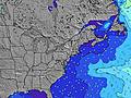 |  |  | 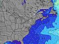 |  |  | 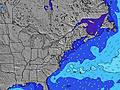 |  |  | ||||||||||||||
Oleaje Altura (m) Dirección Período (s) | ENE 4 | ENE 4 | ENE 5 | E 5 | E 5 | E 5 | ESE 6 | ESE 6 | ESE 6 | ESE 6 | ESE 6 | ESE 6 | ESE 6 | ESE 6 | ESE 6 | SE 9 | E 6 | E 6 | E 7 | ESE 7 | ESE 7 | ESE 7 | ESE 7 | ESE 7 |
Gráfico Olas | ||||||||||||||||||||||||
13 | 29 | 53 | 52 | 51 | 54 | 67 | 72 | 73 | 75 | 68 | 80 | 80 | 38 | 27 | 26 | 17 | 17 | 27 | 18 | 18 | 18 | 18 | 18 | |
Viento (km/h) | ||||||||||||||||||||||||
Estado del Viento Viento de Mar Viento de Mar-Cruzado Cruzado Viento de Tierra-Cruzado Viento de Tierra Cristalino | cross-on | cross-on | on | on | on | on | cross-on | cross-on | cross-on | on | on | cross-on | cross-on | cross-on | cross-on | cross-off | off | glassy | glassy | cross | cross-off | cross-off | cross-off | cross-off |
Marea alta | 6:16AM1.11m | 6:37PM1.48m | 7:16AM1.18m | 7:33PM1.53m | 8:11AM1.23m | 8:26PM1.54m | ||||||||||||||||||
Marea baja | 12:16PM-0.00m | 1:20AM-0.07m | 1:15PM-0.04m | 2:15AM-0.13m | 2:13PM-0.07m | |||||||||||||||||||
5:45 | — | — | — | — | — | — | — | 5:46 | — | — | — | — | — | — | — | 5:47 | — | — | — | — | — | — | 5:48 | |
— | — | — | — | — | 8:24 | — | — | — | — | — | — | — | 8:23 | — | — | — | — | — | — | — | 8:23 | — | 8:22 | |
mm | 1 | 1 | 1 | — | — | — | — | — | — | — | — | — | — | — | — | — | — | — | — | — | — | — | — | — |
Temp. °C | 24 | 24 | 24 | 24 | 24 | 24 | 24 | 24 | 24 | 24 | 24 | 24 | 23 | 23 | 23 | 23 | 22 | 22 | 23 | 24 | 25 | 25 | 24 | 24 |
Enfriamiento °C | 24 | 23 | 23 | 21 | 22 | 22 | 21 | 22 | 23 | 22 | 22 | 23 | 22 | 23 | 23 | 23 | 22 | 22 | 24 | 23 | 22 | 22 | 22 | 22 |
Oleaje 1 Altura (m) Dirección Período (s) | SSE 6 | SSE 6 | SSE 6 | SSE 6 | SSE 6 | S 6 | S 6 | ESE 10 | SE 9 | SE 9 | SE 9 | ESE 6 | ESE 6 | ESE 6 | ESE 6 | ESE 6 | E 6 | E 6 | E 7 | ESE 7 | ESE 7 | ESE 7 | ESE 7 | ESE 7 |
8 | 8 | 4 | 4 | 4 | 3 | 3 | 9 | 14 | 14 | 14 | 80 | 80 | 38 | 27 | 26 | 17 | 17 | 27 | 18 | 18 | 18 | 18 | 18 | |
Oleaje 2 Altura (m) Dirección Período (s) | ESE 10 | ESE 10 | SE 10 | SE 10 | SE 10 | SE 10 | — | S 6 | S 6 | S 6 | — | SE 9 | — | SSE 5 | SSE 5 | SSE 5 | SSE 5 | SSE 5 | SSE 5 | ESE 9 | ESE 9 | ESE 9 | ESE 9 | ESE 9 |
9 | 9 | 14 | 14 | 14 | 14 | — | 3 | 1 | 1 | — | 14 | — | 9 | 5 | 5 | 5 | 5 | 5 | 8 | 8 | 8 | 8 | 8 | |
Oleaje 3 Altura (m) Dirección Período (s) | E 8 | — | — | — | — | — | — | — | — | — | — | — | — | — | SE 9 | SE 9 | ESE 9 | ESE 9 | ESE 9 | SSE 5 | E 8 | SSE 5 | SE 5 | E 8 |
1 | — | — | — | — | — | — | — | — | — | — | — | — | — | 13 | 20 | 8 | 8 | 8 | 5 | 1 | 2 | 1 | 1 | |
Olas de Viento Altura (m) Dirección Período (s) | ENE 4 | ENE 4 | ENE 5 | E 5 | E 5 | E 5 | ESE 6 | ESE 6 | ESE 6 | ESE 6 | ESE 6 | — | — | — | — | — | — | — | — | — | SSE 5 | S 3 | S 3 | SSW 3 |
13 | 29 | 53 | 52 | 51 | 54 | 67 | 72 | 73 | 75 | 68 | — | — | — | — | — | — | — | — | — | 5 | 2 | 5 | 6 | |
Viento del Tierra o Mar Limpio más proximo | ||||||||||||||||||||||||
Distancia (km) | 321 | 340 | 340 | 1181 | 1183 | 445 | 446 | 446 | 152 | 152 | 683 | 1128 | 2423 | 1177 | 498 | 0 | 29 | 54 | 0 | 577 | 580 | 192 | 197 | 197 |
Mejores Olas Previstas en Delaware | ||||||||||||||||||||||||
Mejores Olas Previstas en United States | ||||||||||||||||||||||||
Busca-Olas Global | ||||||||||||||||||||||||
- Map Icons:
 Break
Break Live Wave Height (m)
 Live Wind Speed (km/h)
 Surf Rating (10 Max)
 Ocean Swells (m)
- Wind Speed (km/h)
GRÁTIS! Un widget de Surf-Forecast.com para tu sitio
Este widget grátis de previsiones de surf y tiempo puede ser añadido a cualquier otro sitio y da un resumen de previsiones de olas para Fenwick. Solo necesita cortar y pegar el código HTML de abajo en su web. Puede elegir preferencias de idioma y de unidades (métricas o imperiales) para convenir a los usuarios de su sitio. Clica aquí para obtener el código.
 Nearest