
Previsiones:

Pronóstico Corto PlazoMayormente seco. Warm (max 23°C el lunes por la tarde, min 20°C el lunes por la noche). El viento será generalmente ligero. | |||||||||||||||||||||
lun 27 | martes 28 | miércoles 29 | |||||||||||||||||||
10 AM | 1 PM | 4 PM | 7 PM | 10 PM | 1 AM | 4 AM | 7 AM | 10 AM | 1 PM | 4 PM | 7 PM | 10 PM | 1 AM | 4 AM | 7 AM | 10 AM | 1 PM | 4 PM | 7 PM | 10 PM | |
Mapa de Altura de Olas |  |  |  | 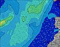 |  |  | 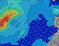 | 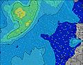 | |||||||||||||
Oleaje Altura (m) Dirección Período (s) | NNE 8 | NNE 8 | NNE 8 | NNE 8 | NNE 8 | NNE 8 | NNE 8 | NNE 8 | NNE 8 | NNE 8 | NNE 8 | NNE 8 | NNE 7 | NNE 7 | NNE 7 | NNE 7 | NNE 7 | NNE 6 | NNE 6 | NNE 6 | NNE 6 |
Gráfico Olas | |||||||||||||||||||||
339 | 283 | 283 | 250 | 250 | 220 | 214 | 204 | 176 | 204 | 176 | 176 | 172 | 167 | 139 | 124 | 117 | 104 | 111 | 119 | 115 | |
Viento (km/h) | |||||||||||||||||||||
Estado del Viento Viento de Mar Viento de Mar-Cruzado Cruzado Viento de Tierra-Cruzado Viento de Tierra Cristalino | on | on | on | on | on | cross-on | on | on | on | on | cross-on | on | on | cross-on | on | on | on | cross-on | cross-on | cross-on | on |
Marea alta | 1:14PM1.85m | 1:36AM1.75m | 1:50PM1.96m | 2:10AM1.83m | 2:23PM2.06m | ||||||||||||||||
Marea baja | 7:29PM0.41m | 7:33AM0.41m | 8:04PM0.32m | 8:06AM0.32m | 8:37PM0.25m | ||||||||||||||||
7:20 | — | — | — | — | — | — | 7:22 | — | — | — | — | — | — | — | 7:22 | — | — | — | — | — | |
— | — | — | 8:54 | — | — | — | — | — | — | — | 8:54 | — | — | — | — | — | — | — | 8:53 | — | |
mm | — | — | — | — | — | — | — | — | — | — | — | — | — | — | — | — | — | — | — | — | — |
Temp. °C | 21 | 22 | 23 | 23 | 21 | 21 | 20 | 20 | 21 | 22 | 22 | 22 | 21 | 20 | 20 | 20 | 21 | 22 | 23 | 22 | 21 |
Enfriamiento °C | 20 | 21 | 23 | 23 | 21 | 21 | 19 | 19 | 20 | 21 | 21 | 21 | 20 | 19 | 19 | 19 | 20 | 21 | 22 | 21 | 20 |
Oleaje 1 Altura (m) Dirección Período (s) | NW 9 | NW 9 | NW 9 | NW 9 | NW 9 | NW 8 | NW 8 | NW 8 | N 13 | N 13 | N 12 | N 12 | N 11 | N 11 | N 11 | NNW 10 | NNW 10 | NNW 10 | N 9 | N 9 | WNW 10 |
3 | 3 | 3 | 3 | 3 | 3 | 3 | 3 | 3 | 3 | 12 | 11 | 10 | 9 | 20 | 20 | 20 | 19 | 14 | 13 | 11 | |
Oleaje 2 Altura (m) Dirección Período (s) | S 13 | S 13 | S 13 | S 13 | S 13 | N 15 | N 14 | N 13 | NW 8 | NW 8 | NW 12 | NW 12 | NW 12 | NW 12 | NW 11 | NW 11 | NW 11 | NW 11 | WNW 11 | N 11 | N 11 |
3 | 3 | 3 | 3 | 3 | 4 | 4 | 4 | 3 | 3 | 6 | 6 | 6 | 5 | 5 | 5 | 5 | 5 | 11 | 9 | 2 | |
Oleaje 3 Altura (m) Dirección Período (s) | W 9 | — | — | — | — | N 15 | — | W 13 | W 13 | W 12 | W 8 | W 8 | W 8 | W 8 | W 8 | NW 8 | NW 8 | NW 8 | N 11 | WNW 11 | W 7 |
2 | — | — | — | — | 4 | — | 3 | 3 | 3 | 1 | 1 | 1 | 1 | 1 | 2 | 2 | 2 | 10 | 11 | 1 | |
Olas de Viento Altura (m) Dirección Período (s) | NNE 8 | NNE 8 | NNE 8 | NNE 8 | NNE 8 | NNE 8 | NNE 8 | NNE 8 | NNE 8 | NNE 8 | NNE 8 | NNE 8 | NNE 7 | NNE 7 | NNE 7 | NNE 7 | NNE 7 | NNE 6 | NNE 6 | NNE 6 | NNE 6 |
339 | 283 | 283 | 250 | 250 | 220 | 214 | 204 | 176 | 204 | 176 | 176 | 172 | 167 | 139 | 124 | 117 | 104 | 111 | 119 | 115 | |
Viento del Tierra o Mar Limpio más proximo | |||||||||||||||||||||
Distancia (km) | 39 | 39 | 69 | 69 | 39 | 39 | 39 | 39 | 39 | 39 | 39 | 39 | 69 | 39 | 123 | 536 | 536 | 190 | 1166 | 626 | 555 |
Mejores Olas Previstas en Gran Canaria | |||||||||||||||||||||
Mejores Olas Previstas en Spain (Africa) | |||||||||||||||||||||
Busca-Olas Global | |||||||||||||||||||||
- Map Icons:
 Break
Break Live Wave Height (m)
 Live Wind Speed (km/h)
 Surf Rating (10 Max)
 Ocean Swells (m)
- Wind Speed (km/h)
GRÁTIS! Un widget de Surf-Forecast.com para tu sitio
Este widget grátis de previsiones de surf y tiempo puede ser añadido a cualquier otro sitio y da un resumen de previsiones de olas para El Paso. Solo necesita cortar y pegar el código HTML de abajo en su web. Puede elegir preferencias de idioma y de unidades (métricas o imperiales) para convenir a los usuarios de su sitio. Clica aquí para obtener el código.
 Nearest