
Previsiones:

Pronóstico Corto PlazoMayormente seco. Warm (max 27°C el domingo por la tarde, min 26°C el domingo por la noche). El viento será generalmente ligero. | ||||||||||||||||||||
dom 2 | lunes 3 | martes 4 | ||||||||||||||||||
12 PM | 3 PM | 6 PM | 9 PM | 12 AM | 3 AM | 6 AM | 9 AM | 12 PM | 3 PM | 6 PM | 9 PM | 12 AM | 3 AM | 6 AM | 9 AM | 12 PM | 3 PM | 6 PM | 9 PM | |
Mapa de Altura de Olas |  | 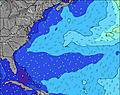 | 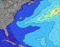 | 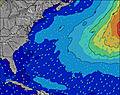 | 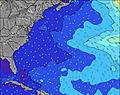 | 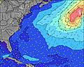 |  | 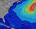 | ||||||||||||
Oleaje Altura (m) Dirección Período (s) | SE 7 | SE 7 | SE 7 | SE 7 | SE 7 | SE 7 | SE 7 | SE 6 | SE 6 | SE 6 | SE 6 | SE 6 | SE 6 | SE 6 | SE 6 | SE 6 | SE 6 | SE 7 | SE 7 | SE 7 |
Gráfico Olas | ||||||||||||||||||||
17 | 67 | 85 | 85 | 85 | 73 | 73 | 70 | 68 | 68 | 66 | 66 | 66 | 47 | 49 | 49 | 51 | 52 | 44 | 45 | |
Viento (km/h) | ||||||||||||||||||||
Estado del Viento Viento de Mar Viento de Mar-Cruzado Cruzado Viento de Tierra-Cruzado Viento de Tierra Cristalino | on | on | on | on | on | on | on | on | on | on | on | on | on | on | on | cross-on | on | on | cross-on | cross-on |
Marea alta | 11:53AM0.88m | 00:05AM0.84m | 12:35PM0.90m | 00:49AM0.80m | 1:21PM0.91m | |||||||||||||||
Marea baja | 6:05PM0.11m | 6:17AM0.05m | 6:53PM0.12m | 6:58AM0.06m | 7:48PM0.14m | |||||||||||||||
— | — | — | — | — | — | 6:33 | — | — | — | — | — | — | — | 6:35 | — | — | — | — | — | |
— | — | 8:15 | — | — | — | — | — | — | — | 8:15 | — | — | — | — | — | — | — | 8:14 | — | |
mm | — | — | — | — | — | — | — | — | — | — | — | — | — | — | — | — | — | — | — | — |
Temp. °C | 27 | 27 | 27 | 27 | 27 | 26 | 26 | 26 | 27 | 27 | 27 | 27 | 27 | 26 | 26 | 26 | 27 | 27 | 27 | 27 |
Enfriamiento °C | 29 | 28 | 28 | 29 | 29 | 27 | 28 | 27 | 28 | 28 | 29 | 29 | 29 | 28 | 28 | 28 | 29 | 30 | 31 | 29 |
Oleaje 1 Altura (m) Dirección Período (s) | W 7 | W 6 | WSW 6 | WSW 6 | WSW 6 | WSW 6 | WSW 6 | WSW 6 | WSW 6 | WSW 6 | W 5 | W 5 | W 5 | SE 6 | SE 6 | NE 8 | NE 8 | SE 7 | SE 7 | SE 7 |
33 | 22 | 13 | 13 | 7 | 7 | 6 | 6 | 3 | 3 | 2 | 2 | 2 | 47 | 49 | 3 | 3 | 52 | 44 | 45 | |
Oleaje 2 Altura (m) Dirección Período (s) | SE 7 | NW 5 | NW 5 | N 6 | N 6 | N 6 | NE 10 | NE 9 | NE 9 | NE 9 | NE 9 | NE 9 | NE 9 | W 5 | W 5 | NE 10 | NE 10 | NNE 10 | NNE 10 | NE 9 |
17 | 1 | 1 | 1 | 1 | 1 | 4 | 3 | 3 | 3 | 3 | 3 | 3 | 1 | 1 | 4 | 4 | 10 | 9 | 14 | |
Oleaje 3 Altura (m) Dirección Período (s) | NW 5 | N 6 | N 6 | NW 5 | NE 10 | NE 10 | N 6 | N 6 | N 5 | N 5 | E 12 | W 7 | W 7 | NE 8 | NE 8 | W 5 | W 7 | W 7 | W 7 | W 7 |
1 | 1 | 1 | 1 | 4 | 4 | 1 | 1 | 1 | 1 | 3 | 1 | 1 | 3 | 3 | 1 | 1 | 1 | 4 | 4 | |
Olas de Viento Altura (m) Dirección Período (s) | SSE 4 | SE 7 | SE 7 | SE 7 | SE 7 | SE 7 | SE 7 | SE 6 | SE 6 | SE 6 | SE 6 | SE 6 | SE 6 | — | — | SE 6 | SE 6 | — | — | — |
13 | 67 | 85 | 85 | 85 | 73 | 73 | 70 | 68 | 68 | 66 | 66 | 66 | — | — | 49 | 51 | — | — | — | |
Viento del Tierra o Mar Limpio más proximo | ||||||||||||||||||||
Distancia (km) | 1590 | 1586 | 1350 | 1350 | 1287 | 1500 | 1500 | 1226 | 1507 | 1594 | 1181 | 1172 | 1140 | 1110 | 1081 | 1094 | 1094 | 1140 | 1139 | 1164 |
Mejores Olas Previstas en Bermuda | ||||||||||||||||||||
Mejores Olas Previstas en Bermuda | ||||||||||||||||||||
Busca-Olas Global | ||||||||||||||||||||
- Map Icons:
 Break
Break Live Wave Height (m)
 Live Wind Speed (km/h)
 Surf Rating (10 Max)
 Ocean Swells (m)
- Wind Speed (km/h)
GRÁTIS! Un widget de Surf-Forecast.com para tu sitio
Este widget grátis de previsiones de surf y tiempo puede ser añadido a cualquier otro sitio y da un resumen de previsiones de olas para Dunkleys. Solo necesita cortar y pegar el código HTML de abajo en su web. Puede elegir preferencias de idioma y de unidades (métricas o imperiales) para convenir a los usuarios de su sitio. Clica aquí para obtener el código.
 Nearest