
Donut Island Surf Guide
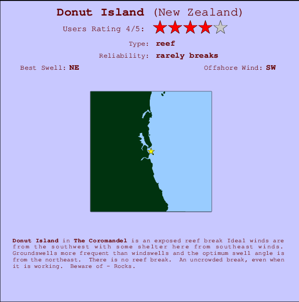
Donut Island in The Coromandel is an exposed reef break Offshore winds blow from the southwest with some shelter here from southeast winds. Most of the surf here comes from groundswells and the ideal swell direction is from the northeast. There is no reef break. The location means that it never gets crowded. Take care of - Rocks.
Donut Island Spot Info
| Type: | Rating: | Reliability: | Todays Sea Temp*: |
|---|---|---|---|
| rarely breaks | 15.2°C*ocean temperature recorded from satellite |
Surfing Donut Island:
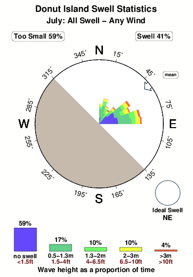
The best conditions reported for surf at Donut Island occur when a Northeast swell combines with an offshore wind direction from the Southwest.

Energía de Olas (poder): 12 horas


Donut Island Surf:
Thursday, 16 July 2026, 18:13 Local time| jueves 16 | ||||
| 9AM | 12PM | 3PM | 6PM | |
| Wave (m) | ||||
| Período (s) | 13 | 12 | 12 | 13 |
| Viento (km/h) | ||||
| Estado del Viento | cross- off |
cross- off |
cross- off |
cross- off |
- /breaks/Donut-Island/forecasts/latest
Donut Island Surf Guide
Donut Island in The Coromandel is an exposed reef break Offshore winds blow from the southwest with some shelter here from southeast winds. Most of the surf here comes from groundswells and the ideal swell direction is from the northeast. There is no reef break. The location means that it never gets crowded. Take care of - Rocks.
Donut Island Spot Info
Type: Rating: Reliability: Todays Sea Temp*:  Reef
Reef 4
4rarely breaks 15.2°C*ocean temperature recorded from satelliteSurfing Donut Island:
The best conditions reported for surf at Donut Island occur when a Northeast swell combines with an offshore wind direction from the Southwest.
Energía de Olas (poder): 12 horas
Usa la barra de navegación de arriba para ver la temperatura del mar en Donut Island, fotografías Donut Island, previsiones detalladas de olas para Donut Island, vientos y previsión del tiempo, webcams para Donut Island, viento actual desde estaciones meteorológicas en Coromandel y predicciones de marea para Donut Island. Las mapas de olas para New Zealand enseñarán un mapa grande de New Zealand y los mares que rodean. Los mapas de olas pueden ser animadas para mostrar diferentes componentes de olas, la altura de ola, la energía de ola, el período, junto con previsiones de viento y del tiempo. Previsiones actuales del tiempo y del estado del mar provienen de boyas marinas de New Zealand, del barcos que transitan en la zona y de estaciones meteorológicas costeras. Cada página de previsiones tiene un Busca-Olas Regional y Global para localizar las mejores condiciones para surfear en el área de Donut Island.
Donut Island Surf:
Thursday, 16 July 2026, 18:13 Local timejueves 16 9AM 12PM 3PM 6PM Wave (m) Período (s) 13 12 12 13 Viento (km/h) Estado del Viento cross-
offcross-
offcross-
offcross-
off- /breaks/Donut-Island/forecasts/latest
- /breaks/Donut-Island/forecasts/latest/six_day
Donut Island Surf Guide
Donut Island in The Coromandel is an exposed reef break Offshore winds blow from the southwest with some shelter here from southeast winds. Most of the surf here comes from groundswells and the ideal swell direction is from the northeast. There is no reef break. The location means that it never gets crowded. Take care of - Rocks.
Donut Island Spot Info
Type: Rating: Reliability: Todays Sea Temp*: Reef4rarely breaks 15.2°C*ocean temperature recorded from satelliteSurfing Donut Island:
The best conditions reported for surf at Donut Island occur when a Northeast swell combines with an offshore wind direction from the Southwest.
Energía de Olas (poder): 12 horas
Usa la barra de navegación de arriba para ver la temperatura del mar en Donut Island, fotografías Donut Island, previsiones detalladas de olas para Donut Island, vientos y previsión del tiempo, webcams para Donut Island, viento actual desde estaciones meteorológicas en Coromandel y predicciones de marea para Donut Island. Las mapas de olas para New Zealand enseñarán un mapa grande de New Zealand y los mares que rodean. Los mapas de olas pueden ser animadas para mostrar diferentes componentes de olas, la altura de ola, la energía de ola, el período, junto con previsiones de viento y del tiempo. Previsiones actuales del tiempo y del estado del mar provienen de boyas marinas de New Zealand, del barcos que transitan en la zona y de estaciones meteorológicas costeras. Cada página de previsiones tiene un Busca-Olas Regional y Global para localizar las mejores condiciones para surfear en el área de Donut Island.
Donut Island Surf:
Thursday, 16 July 2026, 18:13 Local timejueves 16 9AM 12PM 3PM 6PM Wave (m) Período (s) 13 12 12 13 Viento (km/h) Estado del Viento cross-
offcross-
offcross-
offcross-
off- /breaks/Donut-Island/forecasts/latest
Donut Island Surf Guide
Donut Island in The Coromandel is an exposed reef break Offshore winds blow from the southwest with some shelter here from southeast winds. Most of the surf here comes from groundswells and the ideal swell direction is from the northeast. There is no reef break. The location means that it never gets crowded. Take care of - Rocks.
Donut Island Spot Info
Type: Rating: Reliability: Todays Sea Temp*: Reef4rarely breaks 15.2°C*ocean temperature recorded from satelliteSurfing Donut Island:
The best conditions reported for surf at Donut Island occur when a Northeast swell combines with an offshore wind direction from the Southwest.
Energía de Olas (poder): 12 horas
Usa la barra de navegación de arriba para ver la temperatura del mar en Donut Island, fotografías Donut Island, previsiones detalladas de olas para Donut Island, vientos y previsión del tiempo, webcams para Donut Island, viento actual desde estaciones meteorológicas en Coromandel y predicciones de marea para Donut Island. Las mapas de olas para New Zealand enseñarán un mapa grande de New Zealand y los mares que rodean. Los mapas de olas pueden ser animadas para mostrar diferentes componentes de olas, la altura de ola, la energía de ola, el período, junto con previsiones de viento y del tiempo. Previsiones actuales del tiempo y del estado del mar provienen de boyas marinas de New Zealand, del barcos que transitan en la zona y de estaciones meteorológicas costeras. Cada página de previsiones tiene un Busca-Olas Regional y Global para localizar las mejores condiciones para surfear en el área de Donut Island.
Donut Island Surf:
Thursday, 16 July 2026, 18:13 Local timejueves 16 9AM 12PM 3PM 6PM Wave (m) Período (s) 13 12 12 13 Viento (km/h) Estado del Viento cross-
offcross-
offcross-
offcross-
offTide Times:
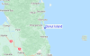
Para Clark Island, a %{dist} %{km} de %{location}.
PROXIMA ES A LAS (hora local) quedan marea alta marea baja Donut Island Tide Times and Tide Chart
Live Weather:
At Whangamata 2, 10 km from Donut Island.
calm
(km/h)
DryAir temperature
13°COverall Donut Island Surf Consistency and Wind Distribution in julio
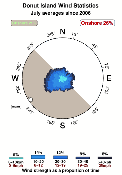


Wind stats for Donut Island: see the variation in direction and stength by month.
Fotos de Surf
de la galeríaContornos: Carreteras y Ríos: Selecciona un spot desde el menú 


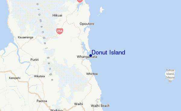
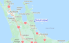
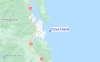
Usa este mapa para navegar hacia las playas de surf de Coromandel y estaciones de marea cercanas de Donut Island
Spots de Surf más cercanos a Donut Island:
(Clica la ubicación para más detalles)- Closest spot1 mi
- Second closest spot1 mi
- Third closest spot1 mi
- Fourth closest spot1 mi
- Fifth closest spot4 mi
Boyas marinas más cercanas a Donut Island:
- Closest Boya Marinas52 mi
- Second closest Boya Marinas119 mi
- Third closest Boya Marinas288 mi
- Fourth closest Boya Marinas289 mi
- Fifth closest Boya Marinas313 mi
Estaciones de marea más cercanas a Donut Island:
- Closest estación de mareaSlipper Island12 mi
- Second closest estación de mareaTairua15 mi
- Third closest estación de mareaRocky Point (Thames)22 mi
- Fourth closest estación de mareaWhitianga29 mi
- Fifth closest estación de mareaTauranga34 mi
Airports
- The closest passenger airport to Donut Island is Tauranga Airport (TRG) in New Zealand, 57 km (35 miles) away (directly).
- The second nearest airport to Donut Island is Hamilton Airport (HLZ), also in New Zealand, 88 km (55 miles) away.
- Third is Auckland International Airport (AKL) in New Zealand, 100 km (62 miles) away.
- Rotorua Airport (ROT) in New Zealand is 106 km (66 miles) away.
- Whakatane Airport (WHK), also in New Zealand is the fifth nearest airport to Donut Island and is 119 km (74 miles) away.
- /breaks/Donut-Island/forecasts/latest
 Nearest