
Dolphins Surf Guide
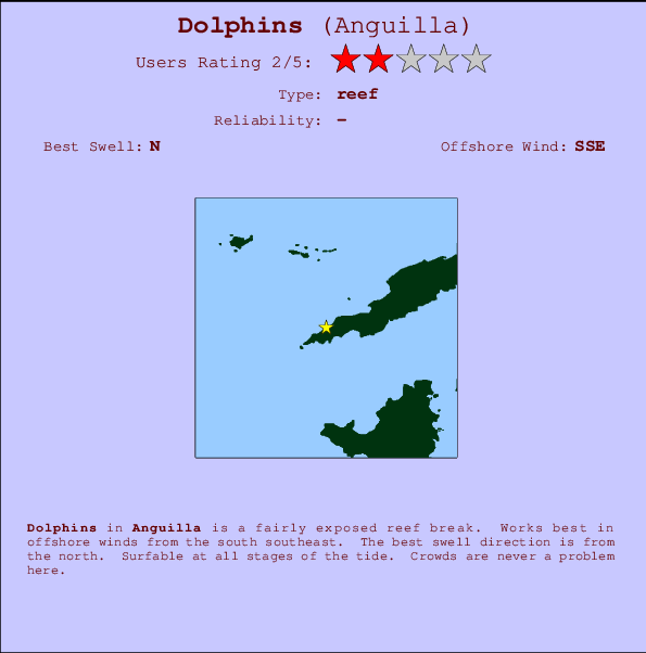
Dolphins in Anguilla is a fairly exposed reef break. Offshore winds blow from the south southeast. The ideal swell direction from the north. Good surf at all stages of the tide. An uncrowded break, even when it is working.
Dolphins Spot Info
| Type: | Rating: | Reliability: | Todays Sea Temp*: |
|---|---|---|---|
28.3°C*ocean temperature recorded from satellite |
Surfing Dolphins:
The best conditions reported for surf at Dolphins occur when a North swell combines with an offshore wind direction from the South-southeast.

Energía de Olas (poder): 12 horas


Dolphins Surf:
Tuesday, 14 July 2026, 22:29 Local time| mar | miércoles 15 | |||
| 11PM | 2AM | 5AM | 8AM | |
| Wave (m) | ||||
| Período (s) | 8 | 7 | 8 | 7 |
| Viento (km/h) | ||||
| Estado del Viento | cross- off |
cross- off |
cross- off |
cross- off |
- /breaks/Dolphins/forecasts/latest
Dolphins Surf Guide
Dolphins in Anguilla is a fairly exposed reef break. Offshore winds blow from the south southeast. The ideal swell direction from the north. Good surf at all stages of the tide. An uncrowded break, even when it is working.
Dolphins Spot Info
Type: Rating: Reliability: Todays Sea Temp*:  Reef
Reef 228.3°C*ocean temperature recorded from satellite
Surfing Dolphins:
The best conditions reported for surf at Dolphins occur when a North swell combines with an offshore wind direction from the South-southeast.
Energía de Olas (poder): 12 horas
Usa la barra de navegación de arriba para ver la temperatura del mar en Dolphins, fotografías Dolphins, previsiones detalladas de olas para Dolphins, vientos y previsión del tiempo, webcams para Dolphins, viento actual desde estaciones meteorológicas en Anguilla y predicciones de marea para Dolphins. Las mapas de olas para Anguilla enseñarán un mapa grande de Anguilla y los mares que rodean. Los mapas de olas pueden ser animadas para mostrar diferentes componentes de olas, la altura de ola, la energía de ola, el período, junto con previsiones de viento y del tiempo. Previsiones actuales del tiempo y del estado del mar provienen de boyas marinas de Anguilla, del barcos que transitan en la zona y de estaciones meteorológicas costeras. Cada página de previsiones tiene un Busca-Olas Regional y Global para localizar las mejores condiciones para surfear en el área de Dolphins.
Dolphins Surf:
Tuesday, 14 July 2026, 22:29 Local timemar miércoles 15 11PM 2AM 5AM 8AM Wave (m) Período (s) 8 7 8 7 Viento (km/h) Estado del Viento cross-
offcross-
offcross-
offcross-
off- /breaks/Dolphins/forecasts/latest
- /breaks/Dolphins/forecasts/latest/six_day
Dolphins Surf Guide
Dolphins in Anguilla is a fairly exposed reef break. Offshore winds blow from the south southeast. The ideal swell direction from the north. Good surf at all stages of the tide. An uncrowded break, even when it is working.
Dolphins Spot Info
Type: Rating: Reliability: Todays Sea Temp*: Reef228.3°C*ocean temperature recorded from satelliteSurfing Dolphins:
The best conditions reported for surf at Dolphins occur when a North swell combines with an offshore wind direction from the South-southeast.
Energía de Olas (poder): 12 horas
Usa la barra de navegación de arriba para ver la temperatura del mar en Dolphins, fotografías Dolphins, previsiones detalladas de olas para Dolphins, vientos y previsión del tiempo, webcams para Dolphins, viento actual desde estaciones meteorológicas en Anguilla y predicciones de marea para Dolphins. Las mapas de olas para Anguilla enseñarán un mapa grande de Anguilla y los mares que rodean. Los mapas de olas pueden ser animadas para mostrar diferentes componentes de olas, la altura de ola, la energía de ola, el período, junto con previsiones de viento y del tiempo. Previsiones actuales del tiempo y del estado del mar provienen de boyas marinas de Anguilla, del barcos que transitan en la zona y de estaciones meteorológicas costeras. Cada página de previsiones tiene un Busca-Olas Regional y Global para localizar las mejores condiciones para surfear en el área de Dolphins.
Dolphins Surf:
Tuesday, 14 July 2026, 22:29 Local timemar miércoles 15 11PM 2AM 5AM 8AM Wave (m) Período (s) 8 7 8 7 Viento (km/h) Estado del Viento cross-
offcross-
offcross-
offcross-
off- /breaks/Dolphins/forecasts/latest
Dolphins Surf Guide
Dolphins in Anguilla is a fairly exposed reef break. Offshore winds blow from the south southeast. The ideal swell direction from the north. Good surf at all stages of the tide. An uncrowded break, even when it is working.
Dolphins Spot Info
Type: Rating: Reliability: Todays Sea Temp*: Reef228.3°C*ocean temperature recorded from satelliteSurfing Dolphins:
The best conditions reported for surf at Dolphins occur when a North swell combines with an offshore wind direction from the South-southeast.
Energía de Olas (poder): 12 horas
Usa la barra de navegación de arriba para ver la temperatura del mar en Dolphins, fotografías Dolphins, previsiones detalladas de olas para Dolphins, vientos y previsión del tiempo, webcams para Dolphins, viento actual desde estaciones meteorológicas en Anguilla y predicciones de marea para Dolphins. Las mapas de olas para Anguilla enseñarán un mapa grande de Anguilla y los mares que rodean. Los mapas de olas pueden ser animadas para mostrar diferentes componentes de olas, la altura de ola, la energía de ola, el período, junto con previsiones de viento y del tiempo. Previsiones actuales del tiempo y del estado del mar provienen de boyas marinas de Anguilla, del barcos que transitan en la zona y de estaciones meteorológicas costeras. Cada página de previsiones tiene un Busca-Olas Regional y Global para localizar las mejores condiciones para surfear en el área de Dolphins.
Dolphins Surf:
Tuesday, 14 July 2026, 22:29 Local timemar miércoles 15 11PM 2AM 5AM 8AM Wave (m) Período (s) 8 7 8 7 Viento (km/h) Estado del Viento cross-
offcross-
offcross-
offcross-
offTide Times:
En Dolphins (0 km).
PROXIMA ES A LAS (hora local) quedan marea alta marea baja Dolphins Tide Times and Tide Chart
Live Weather:
At Wall Blake Airport, 12 km from Dolphins.
light winds from the E
(km/h)Air temperature
28°COverall Dolphins Surf Consistency and Wind Distribution in julio
Fotos de Surf
de la galeríaContornos: Carreteras y Ríos: Selecciona un spot desde el menú 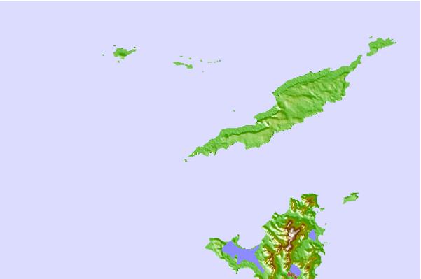
Usa este mapa para navegar hacia las playas de surf de Anguilla y estaciones de marea cercanas de Dolphins
Spots de Surf más cercanos a Dolphins:
(Clica la ubicación para más detalles)- Closest spot7 mi
- Second closest spot9 mi
- Third closest spot9 mi
- Fourth closest spot9 mi
- Fifth closest spot10 mi
Boyas marinas más cercanas a Dolphins:
- Closest Boya Marinas106 mi
- Second closest Boya Marinas119 mi
- Third closest Boya Marinas152 mi
- Fourth closest Boya Marinas195 mi
- Fifth closest Boya Marinas223 mi
Estaciones de marea más cercanas a Dolphins:
- Closest estación de mareaMarigot9 mi
- Second closest estación de mareaDuth Cul de Sac12 mi
- Third closest estación de mareaSaint Barthelemy28 mi
- Fourth closest estación de mareaBasseterre67 mi
- Fifth closest estación de mareaRoad Town101 mi
Airports
- The closest passenger airport to Dolphins is Wallblake (The Valley) Airport (AXA) in Anguilla Isl., 10 km (6 miles) away (directly).
- The second nearest airport to Dolphins is Grand Case (St. Martin) Airport (SFG) in Antilles, 14 km (9 miles) away.
- Third is Princess Juliana International (Philipsburg) Airport (SXM) in Antilles, 17 km (11 miles) away.
- Gustavia/st.barthel (St.-barthelemy) Airport (SBH) in Antilles is 45 km (28 miles) away.
- F D Roosevelt (Oranjestad) Airport (EUX), also in Antilles is the fifth nearest airport to Dolphins and is 79 km (49 miles) away.
- /breaks/Dolphins/forecasts/latest


 Nearest