
Previsiones:

Pronóstico Corto PlazoMayormente seco. Very mild (max 15°C el martes por la mañana, min 8°C el domingo por la mañana). El viento será generalmente ligero. | ||||||||||||||||||||||||
domingo 2 | lunes 3 | martes 4 | ||||||||||||||||||||||
12 AM | 3 AM | 6 AM | 9 AM | 12 PM | 3 PM | 6 PM | 9 PM | 12 AM | 3 AM | 6 AM | 9 AM | 12 PM | 3 PM | 6 PM | 9 PM | 12 AM | 3 AM | 6 AM | 9 AM | 12 PM | 3 PM | 6 PM | 9 PM | |
Mapa de Altura de Olas |  | 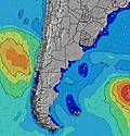 | 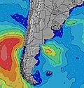 | 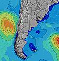 | 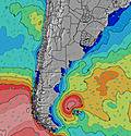 | 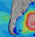 | 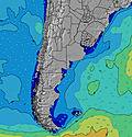 | 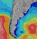 | 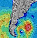 | |||||||||||||||
Oleaje Altura (m) Dirección Período (s) | ENE 10 | ENE 10 | ENE 10 | ENE 10 | ENE 10 | ENE 10 | S 12 | S 11 | S 11 | SSE 11 | SSE 10 | SSE 10 | SSE 11 | SSE 11 | SSE 11 | SE 11 | SE 11 | SE 10 | SE 10 | SE 10 | SE 10 | SE 10 | SE 10 | SE 10 |
Gráfico Olas | ||||||||||||||||||||||||
173 | 173 | 140 | 135 | 105 | 94 | 276 | 350 | 457 | 452 | 478 | 502 | 452 | 480 | 425 | 408 | 361 | 355 | 302 | 290 | 222 | 188 | 185 | 157 | |
Viento (km/h) | ||||||||||||||||||||||||
Estado del Viento Viento de Mar Viento de Mar-Cruzado Cruzado Viento de Tierra-Cruzado Viento de Tierra Cristalino | on | cross-off | off | off | off | off | off | off | off | off | off | off | cross-off | glassy | cross-off | glassy | cross-off | cross-on | cross-on | cross-on | glassy | cross-off | off | off |
Marea alta | 9:09PM1.62m | 9:42AM0.99m | 9:48PM1.60m | 10:19AM1.05m | 10:29PM1.56m | 11:00AM1.12m | ||||||||||||||||||
Marea baja | 4:58AM0.38m | 3:56PM0.62m | 5:33AM0.40m | 4:42PM0.61m | 6:08AM0.43m | 5:33PM0.59m | ||||||||||||||||||
— | — | 7:50 | — | — | — | — | — | — | — | 7:48 | — | — | — | — | — | — | — | 7:48 | — | — | — | — | — | |
— | — | — | — | — | — | 6:01 | — | — | — | — | — | — | — | 6:02 | — | — | — | — | — | — | — | 6:04 | — | |
mm | — | — | — | — | — | — | — | — | — | — | — | — | — | — | — | — | — | — | — | — | — | — | — | — |
Temp. °C | 9 | 8 | 8 | 8 | 9 | 10 | 10 | 9 | 10 | 10 | 10 | 11 | 11 | 12 | 12 | 13 | 13 | 13 | 14 | 15 | 14 | 15 | 14 | 13 |
Enfriamiento °C | 7 | 5 | 5 | 5 | 4 | 7 | 6 | 4 | 7 | 8 | 8 | 9 | 10 | 12 | 11 | 13 | 12 | 11 | 12 | 12 | 12 | 13 | 11 | 9 |
Oleaje 1 Altura (m) Dirección Período (s) | ENE 10 | ENE 10 | ENE 10 | ENE 10 | ENE 10 | SSW 7 | S 12 | S 11 | S 11 | SSE 11 | SSE 10 | SSE 10 | SSE 11 | SSE 11 | SSE 11 | SE 11 | SE 11 | SE 10 | SE 10 | SE 10 | SE 10 | SE 10 | SE 10 | SE 10 |
173 | 173 | 140 | 135 | 105 | 56 | 276 | 350 | 457 | 452 | 478 | 502 | 452 | 480 | 425 | 408 | 361 | 355 | 302 | 290 | 222 | 188 | 185 | 157 | |
Oleaje 2 Altura (m) Dirección Período (s) | SSW 6 | SSW 6 | SSW 6 | SSW 7 | SSW 7 | ENE 10 | ENE 9 | ENE 9 | ENE 9 | ENE 5 | ENE 9 | ENE 9 | ENE 9 | ENE 9 | ENE 9 | ENE 8 | ENE 8 | ENE 8 | ENE 8 | ENE 8 | ENE 8 | ENE 8 | ENE 8 | NE 8 |
53 | 44 | 45 | 50 | 54 | 94 | 110 | 68 | 48 | 14 | 45 | 68 | 44 | 43 | 42 | 41 | 28 | 28 | 28 | 28 | 27 | 26 | 26 | 16 | |
Oleaje 3 Altura (m) Dirección Período (s) | S 11 | S 15 | SSE 14 | SSE 13 | SSE 13 | S 12 | SSW 7 | SSW 7 | SSW 7 | ENE 9 | ENE 4 | S 10 | S 10 | S 10 | S 10 | S 10 | S 10 | S 9 | S 12 | SW 5 | SW 5 | WSW 5 | SW 5 | SW 5 |
2 | 18 | 40 | 60 | 57 | 75 | 41 | 31 | 20 | 47 | 8 | 8 | 2 | 2 | 2 | 2 | 2 | 2 | 3 | 1 | 1 | 2 | 1 | 1 | |
Olas de Viento Altura (m) Dirección Período (s) | — | — | — | — | NE 3 | NNE 3 | — | NE 4 | NE 5 | — | — | — | — | — | — | — | — | — | — | — | — | — | — | NNE 2 |
— | — | — | — | 2 | 4 | — | 22 | 21 | — | — | — | — | — | — | — | — | — | — | — | — | — | — | 1 | |
Viento del Tierra o Mar Limpio más proximo | ||||||||||||||||||||||||
Distancia (km) | 3 | 0 | 0 | 0 | 0 | 0 | 0 | 0 | 0 | 0 | 0 | 0 | 0 | 0 | 0 | 0 | 0 | 1 | 1 | 1 | 0 | 0 | 0 | 0 |
Mejores Olas Previstas en Provincia de Buenos Aires | ||||||||||||||||||||||||
Mejores Olas Previstas en Argentina | ||||||||||||||||||||||||
Busca-Olas Global | ||||||||||||||||||||||||
- Map Icons:
 Break
Break Live Wave Height (m)
 Live Wind Speed (km/h)
 Surf Rating (10 Max)
 Ocean Swells (m)
- Wind Speed (km/h)
GRÁTIS! Un widget de Surf-Forecast.com para tu sitio
Este widget grátis de previsiones de surf y tiempo puede ser añadido a cualquier otro sitio y da un resumen de previsiones de olas para Diva (Mar del Plata). Solo necesita cortar y pegar el código HTML de abajo en su web. Puede elegir preferencias de idioma y de unidades (métricas o imperiales) para convenir a los usuarios de su sitio. Clica aquí para obtener el código.
 Nearest