
Previsiones:

Pronóstico Corto PlazoLluvia ligera (totál 6mm), cayendo mayormente el miércoles por la tarde. Warm (max 32°C el martes por la mañana, min 25°C el martes por la noche). El viento será generalmente ligero. | |||||||||||||||||
lunes 3 | martes 4 | ||||||||||||||||
9 PM | 12 AM | 3 AM | 6 AM | 9 AM | 12 PM | 3 PM | 6 PM | 9 PM | 12 AM | 3 AM | 6 AM | 9 AM | 12 PM | 3 PM | 6 PM | 9 PM | |
Mapa de Altura de Olas |  |  | 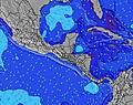 |  |  | 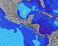 |  | ||||||||||
Oleaje Altura (m) Dirección Período (s) | SW 14 | SW 14 | SW 12 | SW 14 | SW 14 | SW 13 | SW 13 | SW 13 | SW 13 | SSW 13 | SSW 8 | SW 13 | SW 13 | SW 16 | SW 16 | SSW 8 | SW 12 |
Gráfico Olas | |||||||||||||||||
169 | 167 | 124 | 102 | 231 | 250 | 208 | 208 | 138 | 111 | 115 | 80 | 83 | 62 | 73 | 92 | 120 | |
Viento (km/h) | |||||||||||||||||
Estado del Viento Viento de Mar Viento de Mar-Cruzado Cruzado Viento de Tierra-Cruzado Viento de Tierra Cristalino | off | off | off | cross-off | glassy | glassy | on | cross | cross-off | glassy | off | cross-off | cross-off | cross-off | cross-on | cross | cross-off |
Marea alta | 5:36AM2.38m | 5:49PM2.19m | 6:13AM2.38m | 6:30PM2.12m | |||||||||||||
Marea baja | 11:19PM0.31m | 11:47AM0.42m | 11:54PM0.35m | 12:29PM0.43m | |||||||||||||
— | — | 5:31 | — | — | — | — | — | — | — | 5:31 | — | — | — | — | — | — | |
— | — | — | — | — | — | — | 6:06 | — | — | — | — | — | — | — | 6:05 | — | |
mm | — | 1 | — | — | — | — | — | 1 | — | — | — | — | — | — | — | 1 | — |
Temp. °C | 28 | 27 | 26 | 26 | 28 | 31 | 29 | 28 | 28 | 27 | 26 | 26 | 29 | 32 | 31 | 29 | 28 |
Enfriamiento °C | 31 | 31 | 29 | 29 | 32 | 35 | 31 | 31 | 32 | 31 | 30 | 29 | 31 | 35 | 34 | 32 | 31 |
Oleaje 1 Altura (m) Dirección Período (s) | SW 14 | S 7 | S 7 | SSW 8 | SW 14 | SW 13 | SW 13 | SW 13 | S 7 | S 7 | SSW 8 | S 9 | S 9 | S 9 | S 9 | SSW 8 | S 8 |
169 | 36 | 49 | 77 | 231 | 250 | 208 | 208 | 62 | 64 | 115 | 130 | 125 | 96 | 94 | 92 | 90 | |
Oleaje 2 Altura (m) Dirección Período (s) | SW 12 | SW 14 | SW 12 | SW 14 | S 7 | S 7 | S 7 | S 7 | SW 13 | SSW 13 | SW 12 | SW 13 | SW 13 | SW 13 | SW 12 | SW 12 | SW 12 |
112 | 167 | 124 | 89 | 52 | 52 | 49 | 48 | 138 | 111 | 98 | 80 | 83 | 57 | 73 | 52 | 120 | |
Oleaje 3 Altura (m) Dirección Período (s) | S 7 | SW 12 | SW 14 | SW 14 | WSW 13 | SW 16 | SW 16 | SW 16 | WSW 13 | SW 13 | SW 13 | SW 13 | SW 16 | SW 16 | SW 16 | SW 15 | N 4 |
33 | 116 | 93 | 102 | 69 | 69 | 66 | 66 | 67 | 84 | 46 | 60 | 64 | 62 | 61 | 84 | 3 | |
Olas de Viento Altura (m) Dirección Período (s) | — | — | — | — | — | — | — | — | — | — | — | NNE 4 | — | N 4 | — | — | — |
— | — | — | — | — | — | — | — | — | — | — | 1 | — | 1 | — | — | — | |
Viento del Tierra o Mar Limpio más proximo | |||||||||||||||||
Distancia (km) | 0 | 0 | 0 | 0 | 0 | 0 | 9 | 9 | 0 | 0 | 0 | 0 | 0 | 0 | 14 | 56 | 0 |
Mejores Olas Previstas en Guanacaste | |||||||||||||||||
Mejores Olas Previstas en Costa Rica | |||||||||||||||||
Busca-Olas Global | |||||||||||||||||
- Map Icons:
 Break
Break Live Wave Height (m)
 Live Wind Speed (km/h)
 Surf Rating (10 Max)
 Ocean Swells (m)
- Wind Speed (km/h)
GRÁTIS! Un widget de Surf-Forecast.com para tu sitio
Este widget grátis de previsiones de surf y tiempo puede ser añadido a cualquier otro sitio y da un resumen de previsiones de olas para Diria. Solo necesita cortar y pegar el código HTML de abajo en su web. Puede elegir preferencias de idioma y de unidades (métricas o imperiales) para convenir a los usuarios de su sitio. Clica aquí para obtener el código.
 Nearest