
Previsiones:

Pronóstico Corto PlazoFuerte lluvia (totál 27mm), más pesada durante la tarde de miércoles. Warm (max 31°C el lunes por la noche, min 27°C el miércoles por la noche). Vientos crecientes (Vientos ligeros desde el SSO el miércoles por la tarde, vientos frescos desde el OSO por la tarde de jueves). | ||||||||||||||||||||||||
martes 28 | miércoles 29 | jueves 30 | ||||||||||||||||||||||
1 AM | 4 AM | 7 AM | 10 AM | 1 PM | 4 PM | 7 PM | 10 PM | 1 AM | 4 AM | 7 AM | 10 AM | 1 PM | 4 PM | 7 PM | 10 PM | 1 AM | 4 AM | 7 AM | 10 AM | 1 PM | 4 PM | 7 PM | 10 PM | |
Mapa de Altura de Olas | 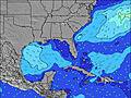 | 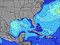 |  | 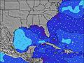 | 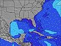 |  | 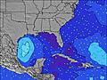 | 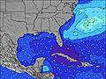 |  | |||||||||||||||
Oleaje Altura (m) Dirección Período (s) | WSW 3 | S 8 | SW 4 | SW 4 | SSW 4 | S 6 | W 3 | WSW 3 | WSW 4 | W 4 | SW 4 | W 4 | W 4 | WSW 4 | WSW 4 | WSW 4 | WSW 4 | W 5 | W 4 | W 4 | W 4 | WSW 4 | SW 4 | SW 4 |
Gráfico Olas | ||||||||||||||||||||||||
4 | 1 | 4 | 2 | 1 | 1 | 0 | 0 | 0 | 0 | 7 | 0 | 0 | 0 | 0 | 19 | 35 | 0 | 0 | 0 | 0 | 0 | 22 | 40 | |
Viento (km/h) | ||||||||||||||||||||||||
Estado del Viento Viento de Mar Viento de Mar-Cruzado Cruzado Viento de Tierra-Cruzado Viento de Tierra Cristalino | cross | cross-off | cross-off | off | cross | cross | cross | cross | cross-off | cross-off | cross-off | cross-off | cross | cross | cross-on | cross | cross-on | cross | cross-off | cross-off | cross | cross-off | off | cross |
Marea alta | 10:02AM0.48m | 10:37AM0.47m | 11:08AM0.44m | |||||||||||||||||||||
Marea baja | 10:03PM-0.05m | 10:28PM-0.03m | ||||||||||||||||||||||
— | 6:07 | — | — | — | — | — | — | — | 6:07 | — | — | — | — | — | — | — | 6:09 | — | — | — | — | — | — | |
— | — | — | — | — | — | 7:49 | — | — | — | — | — | — | — | 7:47 | — | — | — | — | — | — | — | 7:46 | — | |
mm | 1 | 1 | — | — | — | — | — | — | — | — | — | — | — | — | 10 | — | — | 1 | 5 | 3 | — | 2 | 3 | — |
Temp. °C | 31 | 29 | 28 | 30 | 31 | 30 | 31 | 31 | 30 | 29 | 29 | 30 | 30 | 30 | 28 | 29 | 29 | 29 | 27 | 29 | 29 | 28 | 27 | 28 |
Enfriamiento °C | 32 | 31 | 29 | 32 | 32 | 29 | 31 | 32 | 32 | 30 | 30 | 31 | 31 | 30 | 31 | 31 | 33 | 31 | 28 | 30 | 29 | 26 | 25 | 29 |
Oleaje 1 Altura (m) Dirección Período (s) | S 8 | S 8 | SW 4 | SW 4 | SSW 4 | S 6 | — | — | — | — | SW 4 | — | — | — | — | — | — | — | — | — | — | — | — | — |
1 | 1 | 4 | 2 | 1 | 1 | — | — | — | — | 7 | — | — | — | — | — | — | — | — | — | — | — | — | — | |
Oleaje 2 Altura (m) Dirección Período (s) | — | — | S 8 | — | — | — | — | — | — | — | — | — | — | — | — | — | — | — | — | — | — | — | — | — |
— | — | 1 | — | — | — | — | — | — | — | — | — | — | — | — | — | — | — | — | — | — | — | — | — | |
Oleaje 3 Altura (m) Dirección Período (s) | — | — | — | — | S 6 | — | — | — | — | — | — | — | — | — | — | — | — | — | — | — | — | — | — | — |
— | — | — | — | 1 | — | — | — | — | — | — | — | — | — | — | — | — | — | — | — | — | — | — | — | |
Olas de Viento Altura (m) Dirección Período (s) | WSW 3 | W 3 | WNW 3 | NW 4 | WNW 4 | W 3 | W 3 | WSW 3 | WSW 4 | W 4 | NW 3 | W 4 | W 4 | WSW 4 | WSW 4 | WSW 4 | WSW 4 | W 5 | W 4 | W 4 | W 4 | WSW 4 | SW 4 | SW 4 |
4 | 6 | 4 | 6 | 2 | 5 | 6 | 7 | 10 | 14 | 3 | 11 | 7 | 7 | 7 | 19 | 35 | 43 | 33 | 22 | 17 | 11 | 22 | 40 | |
Viento del Tierra o Mar Limpio más proximo | ||||||||||||||||||||||||
Distancia (km) | 1251 | 1321 | 1500 | 1696 | 1244 | 1244 | 1162 | 1251 | 1063 | 909 | 909 | 821 | 909 | 909 | 944 | 142 | 224 | 780 | 974 | 821 | 1025 | 1092 | 1151 | 1481 |
Mejores Olas Previstas en Alabama | ||||||||||||||||||||||||
Mejores Olas Previstas en United States | ||||||||||||||||||||||||
Busca-Olas Global | ||||||||||||||||||||||||
- Map Icons:
 Break
Break Live Wave Height (m)
 Live Wind Speed (km/h)
 Surf Rating (10 Max)
 Ocean Swells (m)
- Wind Speed (km/h)
GRÁTIS! Un widget de Surf-Forecast.com para tu sitio
Este widget grátis de previsiones de surf y tiempo puede ser añadido a cualquier otro sitio y da un resumen de previsiones de olas para Dauphin Island Pier. Solo necesita cortar y pegar el código HTML de abajo en su web. Puede elegir preferencias de idioma y de unidades (métricas o imperiales) para convenir a los usuarios de su sitio. Clica aquí para obtener el código.
 Nearest