
Previsiones:

Pronóstico Corto PlazoMayormente seco. Warm (max 26°C el martes por la tarde, min 25°C el martes por la tarde). Mayormente vientos frescos. | ||||||||||||||||||||||||
mar 14 | miércoles 15 | jueves 16 | vie 17 | |||||||||||||||||||||
1 PM | 4 PM | 7 PM | 10 PM | 1 AM | 4 AM | 7 AM | 10 AM | 1 PM | 4 PM | 7 PM | 10 PM | 1 AM | 4 AM | 7 AM | 10 AM | 1 PM | 4 PM | 7 PM | 10 PM | 1 AM | 4 AM | 7 AM | 10 AM | |
Mapa de Altura de Olas |  |  |  |  |  |  |  |  |  | 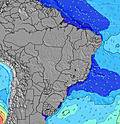 | ||||||||||||||
Oleaje Altura (m) Dirección Período (s) | SSW 20 | SSW 19 | NNE 8 | NNE 8 | NNE 9 | NNE 9 | NNE 9 | NNE 8 | NNE 8 | NNE 8 | NNE 8 | NNE 8 | NNE 8 | NNE 8 | NNE 8 | NNE 8 | NNE 8 | NNE 8 | N 11 | N 11 | N 10 | N 10 | N 10 | N 10 |
Gráfico Olas | ||||||||||||||||||||||||
0 | 0 | 12 | 14 | 15 | 15 | 15 | 24 | 24 | 23 | 23 | 22 | 13 | 13 | 13 | 13 | 12 | 11 | 20 | 20 | 19 | 18 | 8 | 8 | |
Viento (km/h) | ||||||||||||||||||||||||
Estado del Viento Viento de Mar Viento de Mar-Cruzado Cruzado Viento de Tierra-Cruzado Viento de Tierra Cristalino | cross-off | cross-off | cross-off | cross-off | cross-off | cross-off | cross-off | cross-off | cross-off | cross-off | off | cross-off | cross-off | cross-off | cross-off | cross-off | cross-off | cross-off | cross-off | cross-off | cross-off | cross-off | cross-off | cross-off |
Marea alta | 5:29PM1.89m | 5:48AM1.85m | 6:16PM1.89m | 6:37AM1.87m | 7:01PM1.84m | 7:23AM1.85m | ||||||||||||||||||
Marea baja | 11:12AM-0.14m | 11:41PM-0.05m | 12:02PM-0.15m | 00:27AM-0.08m | 12:50PM-0.12m | 1:13AM-0.08m | ||||||||||||||||||
— | — | — | — | — | 6:18 | — | — | — | — | — | — | — | 6:18 | — | — | — | — | — | — | — | 6:18 | — | — | |
— | 6:13 | — | — | — | — | — | — | — | 6:13 | — | — | — | — | — | — | — | 6:13 | — | — | — | — | — | 6:13 | |
mm | — | — | — | — | — | — | — | — | — | — | — | — | — | — | — | — | — | — | — | — | — | — | — | — |
Temp. °C | 25 | 26 | 25 | 25 | 25 | 26 | 26 | 26 | 26 | 26 | 26 | 26 | 26 | 25 | 25 | 25 | 26 | 26 | 26 | 26 | 25 | 25 | 25 | 26 |
Enfriamiento °C | 25 | 26 | 25 | 25 | 25 | 26 | 24 | 25 | 24 | 24 | 24 | 24 | 24 | 24 | 24 | 24 | 24 | 25 | 24 | 24 | 23 | 22 | 22 | 23 |
Oleaje 1 Altura (m) Dirección Período (s) | E 7 | ESE 7 | SSW 19 | SSW 19 | SSW 18 | S 18 | S 18 | SSW 15 | S 13 | S 13 | S 13 | S 12 | S 12 | S 12 | S 12 | S 11 | S 11 | S 11 | S 14 | S 13 | S 12 | S 12 | S 12 | S 12 |
109 | 86 | 124 | 117 | 104 | 158 | 158 | 73 | 92 | 85 | 84 | 110 | 73 | 106 | 101 | 91 | 89 | 119 | 179 | 222 | 305 | 295 | 229 | 217 | |
Oleaje 2 Altura (m) Dirección Período (s) | SSE 11 | S 11 | SSE 10 | SSE 10 | SSE 10 | SSE 10 | SSE 10 | NNE 8 | SSW 16 | S 16 | S 16 | SSW 16 | SSW 16 | SSW 15 | SSW 15 | S 15 | S 15 | S 14 | S 11 | S 10 | N 10 | N 10 | S 10 | S 9 |
38 | 57 | 35 | 34 | 20 | 19 | 33 | 24 | 90 | 131 | 131 | 85 | 82 | 74 | 73 | 110 | 109 | 107 | 82 | 80 | 19 | 18 | 67 | 59 | |
Oleaje 3 Altura (m) Dirección Período (s) | SSW 20 | SSW 19 | NNE 8 | NNE 8 | NNE 9 | NNE 9 | NNE 9 | SSE 10 | NNE 8 | NNE 8 | NNE 8 | NNE 8 | NNE 8 | NNE 8 | NNE 8 | NNE 8 | NNE 8 | NNE 8 | N 11 | N 11 | NNE 7 | NNE 7 | N 10 | N 10 |
127 | 125 | 12 | 14 | 15 | 15 | 15 | 33 | 24 | 23 | 23 | 22 | 13 | 13 | 13 | 13 | 12 | 11 | 20 | 20 | 5 | 5 | 8 | 8 | |
Olas de Viento Altura (m) Dirección Período (s) | — | — | ESE 7 | ESE 7 | E 7 | E 7 | ESE 7 | ESE 7 | ESE 7 | ESE 7 | ESE 5 | ESE 5 | ESE 5 | ESE 5 | ESE 5 | ESE 5 | ESE 5 | ESE 6 | ESE 6 | ESE 6 | ESE 6 | ESE 6 | ESE 6 | ESE 6 |
— | — | 86 | 86 | 83 | 83 | 84 | 84 | 86 | 108 | 50 | 56 | 64 | 69 | 69 | 70 | 102 | 118 | 151 | 182 | 197 | 197 | 197 | 213 | |
Viento del Tierra o Mar Limpio más proximo | ||||||||||||||||||||||||
Distancia (km) | 2304 | 2304 | 2021 | 2304 | 1848 | 438 | 2021 | 1995 | 2021 | 2015 | 1954 | 1931 | 1931 | 1315 | 1319 | 1931 | 1329 | 1931 | 1931 | 1931 | 1931 | 369 | 369 | 1332 |
Mejores Olas Previstas en Fernando De Noronha | ||||||||||||||||||||||||
Mejores Olas Previstas en Brazil | ||||||||||||||||||||||||
Busca-Olas Global | ||||||||||||||||||||||||
- Map Icons:
 Break
Break Live Wave Height (m)
 Live Wind Speed (km/h)
 Surf Rating (10 Max)
 Ocean Swells (m)
- Wind Speed (km/h)
GRÁTIS! Un widget de Surf-Forecast.com para tu sitio
Este widget grátis de previsiones de surf y tiempo puede ser añadido a cualquier otro sitio y da un resumen de previsiones de olas para Conceicao. Solo necesita cortar y pegar el código HTML de abajo en su web. Puede elegir preferencias de idioma y de unidades (métricas o imperiales) para convenir a los usuarios de su sitio. Clica aquí para obtener el código.
 Nearest