
Previsiones:

Pronóstico Corto PlazoFuerte lluvia (totál 35mm), más pesada durante la noche de jueves. Warm (max 31°C el sábado por la mañana, min 25°C el jueves por la noche). El viento será generalmente ligero. | |||||||||||||||||
viernes 24 | sábado 25 | ||||||||||||||||
9 PM | 12 AM | 3 AM | 6 AM | 9 AM | 12 PM | 3 PM | 6 PM | 9 PM | 12 AM | 3 AM | 6 AM | 9 AM | 12 PM | 3 PM | 6 PM | 9 PM | |
Mapa de Altura de Olas |  | | 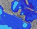 |  |  | 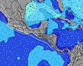 |  | ||||||||||
Oleaje Altura (m) Dirección Período (s) | SW 13 | SSW 9 | SSW 8 | SSW 24 | SSW 24 | SSW 24 | SSW 24 | SSW 24 | SSW 22 | SSW 21 | SSW 21 | SSW 21 | SSW 21 | SSW 21 | SSW 21 | SSW 20 | SSW 19 |
Gráfico Olas | |||||||||||||||||
84 | 158 | 221 | 487 | 704 | 704 | 487 | 368 | 415 | 952 | 1410 | 1410 | 943 | 578 | 557 | 790 | 1159 | |
Viento (km/h) | |||||||||||||||||
Estado del Viento Viento de Mar Viento de Mar-Cruzado Cruzado Viento de Tierra-Cruzado Viento de Tierra Cristalino | cross-on | glassy | cross-off | cross-off | glassy | cross-on | cross | cross | cross-off | off | off | cross-off | glassy | on | on | on | glassy |
Marea alta | 10:02PM1.50m | 10:28AM1.78m | 11:02PM1.46m | 11:25AM1.76m | |||||||||||||
Marea baja | 4:01AM0.60m | 5:06PM0.57m | 4:59AM0.63m | 6:05PM0.55m | |||||||||||||
— | — | 5:39 | — | — | — | — | — | — | — | 5:39 | — | — | — | — | — | — | |
— | — | — | — | — | — | — | 6:27 | — | — | — | — | — | — | — | 6:27 | — | |
mm | 3 | 5 | 8 | 1 | — | 1 | — | 1 | 1 | — | — | — | — | — | — | 1 | 4 |
Temp. °C | 26 | 26 | 25 | 25 | 28 | 28 | 29 | 28 | 27 | 26 | 25 | 25 | 29 | 31 | 29 | 28 | 27 |
Enfriamiento °C | 30 | 31 | 29 | 28 | 32 | 31 | 30 | 30 | 29 | 29 | 28 | 27 | 32 | 32 | 32 | 32 | 31 |
Oleaje 1 Altura (m) Dirección Período (s) | SSE 6 | SE 6 | SSW 8 | SSW 8 | SSW 8 | SSW 8 | SSW 8 | SW 8 | SSW 8 | SW 8 | SSW 21 | SSW 21 | SSW 21 | SSW 8 | SSW 8 | SSW 20 | SSW 19 |
52 | 23 | 221 | 244 | 223 | 223 | 222 | 206 | 224 | 196 | 1410 | 1410 | 943 | 93 | 76 | 790 | 1159 | |
Oleaje 2 Altura (m) Dirección Período (s) | S 8 | SW 18 | SE 6 | SSW 24 | SSW 24 | SSW 24 | SSW 24 | SSW 24 | SSW 22 | SSW 21 | SW 8 | SSW 8 | SSW 8 | SSW 21 | SSW 21 | SSW 8 | SSW 8 |
30 | 79 | 12 | 487 | 704 | 704 | 487 | 368 | 415 | 952 | 151 | 126 | 103 | 578 | 557 | 91 | 74 | |
Oleaje 3 Altura (m) Dirección Período (s) | SW 13 | SW 13 | SW 18 | SW 13 | SW 13 | SE 6 | SE 6 | SW 12 | SW 12 | SW 12 | SW 12 | SW 12 | SW 12 | SW 12 | SW 12 | SW 12 | SW 11 |
84 | 46 | 79 | 45 | 44 | 14 | 25 | 74 | 74 | 72 | 71 | 69 | 69 | 68 | 67 | 65 | 61 | |
Olas de Viento Altura (m) Dirección Período (s) | SSW 4 | SSW 9 | — | — | — | — | — | — | WSW 4 | — | — | — | — | — | SSE 7 | — | — |
15 | 158 | — | — | — | — | — | — | 16 | — | — | — | — | — | 10 | — | — | |
Viento del Tierra o Mar Limpio más proximo | |||||||||||||||||
Distancia (km) | 19 | 0 | 0 | 0 | 0 | 314 | 365 | 361 | 0 | 0 | 0 | 0 | 0 | 314 | 218 | 10 | 0 |
Mejores Olas Previstas en El-Salvador - Costa del Balsamo | |||||||||||||||||
Mejores Olas Previstas en El Salvador | |||||||||||||||||
Busca-Olas Global | |||||||||||||||||
- Map Icons:
 Break
Break Live Wave Height (m)
 Live Wind Speed (km/h)
 Surf Rating (10 Max)
 Ocean Swells (m)
- Wind Speed (km/h)
GRÁTIS! Un widget de Surf-Forecast.com para tu sitio
Este widget grátis de previsiones de surf y tiempo puede ser añadido a cualquier otro sitio y da un resumen de previsiones de olas para Comasagua Point. Solo necesita cortar y pegar el código HTML de abajo en su web. Puede elegir preferencias de idioma y de unidades (métricas o imperiales) para convenir a los usuarios de su sitio. Clica aquí para obtener el código.
 Nearest