
Previsiones:

Pronóstico Corto PlazoLluvia moderada (totál 12mm), más pesada el lunes por la tarde. Warm (max 21°C el sábado por la mañana, min 19°C el lunes por la tarde). Mayormente vientos frescos. | |||||||||||||||||||||||
sábado 25 | domingo 26 | lunes 27 | |||||||||||||||||||||
5 AM | 8 AM | 11 AM | 2 PM | 5 PM | 8 PM | 11 PM | 2 AM | 5 AM | 8 AM | 11 AM | 2 PM | 5 PM | 8 PM | 11 PM | 2 AM | 5 AM | 8 AM | 11 AM | 2 PM | 5 PM | 8 PM | 11 PM | |
Mapa de Altura de Olas | 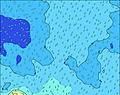 | 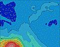 | 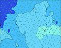 |  | 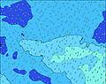 | 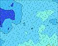 | 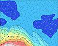 | 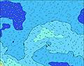 | 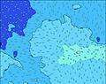 | ||||||||||||||
Oleaje Altura (m) Dirección Período (s) | ENE 8 | ENE 8 | ENE 8 | ENE 8 | ENE 8 | ENE 7 | ENE 7 | ENE 7 | ENE 7 | NE 12 | NE 11 | ENE 7 | NE 11 | NE 11 | NE 11 | NE 11 | NE 11 | NE 11 | NE 11 | SW 10 | SW 12 | SW 12 | SW 12 |
Gráfico Olas | |||||||||||||||||||||||
60 | 45 | 45 | 32 | 32 | 18 | 18 | 18 | 18 | 22 | 19 | 10 | 42 | 42 | 41 | 72 | 71 | 71 | 71 | 0 | 0 | 0 | 0 | |
Viento (km/h) | |||||||||||||||||||||||
Estado del Viento Viento de Mar Viento de Mar-Cruzado Cruzado Viento de Tierra-Cruzado Viento de Tierra Cristalino | cross-off | cross-off | cross-off | cross-off | cross-off | cross-off | cross-off | cross-off | cross-off | cross-off | cross-off | cross | cross | cross | cross | cross | cross-off | cross-off | cross-off | cross-off | cross-off | cross-off | cross-off |
Marea alta | 6:13AM0.50m | 6:42PM0.36m | 6:50AM0.54m | 7:18PM0.39m | 7:25AM0.57m | 7:53PM0.42m | |||||||||||||||||
Marea baja | 12:29PM0.01m | 00:21AM0.07m | 1:05PM-0.02m | 00:57AM0.05m | 1:39PM-0.04m | ||||||||||||||||||
7:13 | — | — | — | — | — | — | — | 7:13 | — | — | — | — | — | — | — | 7:11 | — | — | — | — | — | — | |
— | — | — | — | 6:16 | — | — | — | — | — | — | — | 6:17 | — | — | — | — | — | — | — | 6:17 | — | — | |
mm | — | — | — | — | — | — | — | — | — | — | — | — | — | — | — | — | 1 | 1 | 1 | 3 | 1 | 3 | 1 |
Temp. °C | 21 | 21 | 21 | 21 | 21 | 21 | 21 | 21 | 21 | 21 | 21 | 20 | 20 | 21 | 21 | 21 | 21 | 20 | 20 | 19 | 20 | 20 | 21 |
Enfriamiento °C | 18 | 19 | 19 | 17 | 17 | 19 | 20 | 20 | 19 | 20 | 21 | 20 | 19 | 18 | 17 | 17 | 18 | 17 | 17 | 16 | 17 | 19 | 19 |
Oleaje 1 Altura (m) Dirección Período (s) | SSW 13 | SSW 13 | SSW 13 | SSW 13 | SSW 12 | SSW 12 | SSW 12 | SSW 12 | SSW 12 | SSW 12 | SSW 12 | SSW 12 | SSW 11 | SSW 11 | SSW 11 | SSW 11 | SSW 10 | SSW 10 | S 11 | SW 10 | SW 12 | SW 12 | SW 12 |
2386 | 2274 | 2172 | 1958 | 1869 | 1788 | 1626 | 1430 | 1252 | 1121 | 953 | 843 | 615 | 582 | 531 | 392 | 370 | 326 | 231 | 334 | 929 | 954 | 907 | |
Oleaje 2 Altura (m) Dirección Período (s) | ENE 8 | ENE 8 | ENE 8 | ENE 8 | ENE 8 | ENE 7 | ENE 7 | ENE 7 | ENE 7 | ENE 7 | ENE 7 | ENE 7 | NE 11 | NE 11 | NE 11 | NE 11 | NE 11 | NE 11 | SSW 17 | SW 13 | WSW 16 | WSW 15 | WSW 15 |
60 | 45 | 45 | 32 | 32 | 18 | 18 | 18 | 18 | 18 | 18 | 10 | 42 | 42 | 41 | 72 | 71 | 71 | 202 | 205 | 171 | 209 | 193 | |
Oleaje 3 Altura (m) Dirección Período (s) | SE 14 | SE 12 | SE 12 | SE 12 | SE 13 | SE 13 | SE 13 | SE 13 | SE 13 | NE 12 | NE 11 | SW 11 | ENE 7 | ENE 7 | ENE 7 | SW 18 | SW 18 | SW 18 | NE 11 | S 11 | S 11 | SSE 13 | SSE 13 |
50 | 40 | 39 | 40 | 28 | 27 | 27 | 27 | 27 | 22 | 19 | 19 | 10 | 10 | 9 | 82 | 80 | 78 | 71 | 114 | 81 | 141 | 141 | |
Olas de Viento Altura (m) Dirección Período (s) | — | — | — | — | — | — | — | — | — | — | — | — | — | — | WNW 3 | W 4 | W 4 | W 5 | WSW 10 | — | — | — | — |
— | — | — | — | — | — | — | — | — | — | — | — | — | — | 9 | 15 | 33 | 51 | 340 | — | — | — | — | |
Viento del Tierra o Mar Limpio más proximo | |||||||||||||||||||||||
Distancia (km) | 4 | 6 | 4 | 6 | 4 | 4 | 4 | 6 | 4 | 4 | 4 | 4 | 6 | 995 | 1117 | 1117 | 1044 | 999 | 995 | 995 | 995 | 6 | 6 |
Mejores Olas Previstas en Cook-Islands - Rarotonga | |||||||||||||||||||||||
Mejores Olas Previstas en Cook Islands | |||||||||||||||||||||||
Busca-Olas Global | |||||||||||||||||||||||
- Map Icons:
 Break
Break Live Wave Height (m)
 Live Wind Speed (km/h)
 Surf Rating (10 Max)
 Ocean Swells (m)
- Wind Speed (km/h)
GRÁTIS! Un widget de Surf-Forecast.com para tu sitio
Este widget grátis de previsiones de surf y tiempo puede ser añadido a cualquier otro sitio y da un resumen de previsiones de olas para Club Raro. Solo necesita cortar y pegar el código HTML de abajo en su web. Puede elegir preferencias de idioma y de unidades (métricas o imperiales) para convenir a los usuarios de su sitio. Clica aquí para obtener el código.
 Nearest