
Previsiones:

Pronóstico Corto PlazoFuerte lluvia (totál 21mm), más pesada durante la noche de miércoles. Warm (max 31°C el lunes por la tarde, min 28°C el martes por la mañana). Vientos crecientes (Vientos ligeros desde el SSO el lunes por la tarde, vientos frescos desde el SO por la tarde de miércoles). | |||||||||||||||||||||
lun 27 | martes 28 | miércoles 29 | |||||||||||||||||||
10 AM | 1 PM | 4 PM | 7 PM | 10 PM | 1 AM | 4 AM | 7 AM | 10 AM | 1 PM | 4 PM | 7 PM | 10 PM | 1 AM | 4 AM | 7 AM | 10 AM | 1 PM | 4 PM | 7 PM | 10 PM | |
Mapa de Altura de Olas | 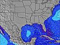 | 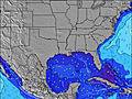 | 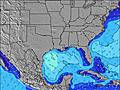 | 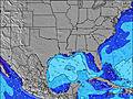 | 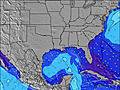 | 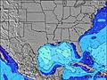 | 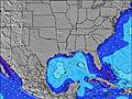 | 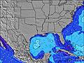 | |||||||||||||
Oleaje Altura (m) Dirección Período (s) | NW 3 | NW 3 | — | SW 2 | SW 3 | S 8 | SW 4 | S 8 | S 8 | S 9 | W 3 | S 9 | S 6 | S 9 | S 8 | W 3 | W 3 | W 3 | WSW 3 | SW 3 | SW 4 |
Gráfico Olas | |||||||||||||||||||||
0 | 0 | 0 | 0 | 0 | 1 | 4 | 1 | 1 | 1 | 0 | 2 | 1 | 1 | 1 | 0 | 0 | 0 | 0 | 0 | 0 | |
Viento (km/h) | |||||||||||||||||||||
Estado del Viento Viento de Mar Viento de Mar-Cruzado Cruzado Viento de Tierra-Cruzado Viento de Tierra Cristalino | off | off | cross | cross-off | cross-off | cross-off | off | off | off | off | cross-off | cross-off | cross-off | cross-off | cross-off | off | off | off | cross-off | cross-off | cross |
Marea alta | 8:40AM0.64m | 9:27AM0.64m | 10:11AM0.62m | ||||||||||||||||||
Marea baja | 7:45PM0.05m | 8:25PM0.07m | 9:01PM0.10m | ||||||||||||||||||
6:11 | — | — | — | — | — | 6:11 | — | — | — | — | — | — | — | 6:11 | — | — | — | — | — | — | |
— | — | — | 7:52 | — | — | — | — | — | — | — | 7:51 | — | — | — | — | — | — | — | 7:50 | — | |
mm | 2 | — | — | — | — | 1 | 1 | 2 | 1 | 1 | — | — | — | — | — | — | — | — | — | — | 5 |
Temp. °C | 29 | 30 | 31 | 31 | 30 | 29 | 29 | 29 | 28 | 30 | 31 | 31 | 30 | 29 | 29 | 28 | 28 | 29 | 31 | 31 | 30 |
Enfriamiento °C | 31 | 33 | 33 | 32 | 31 | 30 | 30 | 31 | 29 | 33 | 32 | 33 | 32 | 30 | 31 | 29 | 29 | 31 | 33 | 30 | 33 |
Oleaje 1 Altura (m) Dirección Período (s) | — | — | — | — | — | S 8 | SW 4 | S 8 | — | — | — | — | S 6 | S 6 | — | — | — | — | — | — | — |
— | — | — | — | — | 1 | 4 | 1 | — | — | — | — | 1 | 1 | — | — | — | — | — | — | — | |
Oleaje 2 Altura (m) Dirección Período (s) | — | — | — | — | — | — | S 8 | S 8 | S 8 | — | — | — | — | S 9 | S 8 | — | — | NW 4 | — | — | — |
— | — | — | — | — | — | 1 | 1 | 1 | — | — | — | — | 1 | 1 | — | — | 1 | — | — | — | |
Oleaje 3 Altura (m) Dirección Período (s) | — | — | — | — | — | — | — | — | — | S 9 | — | S 9 | — | — | — | — | — | — | — | — | — |
— | — | — | — | — | — | — | — | — | 1 | — | 2 | — | — | — | — | — | — | — | — | — | |
Olas de Viento Altura (m) Dirección Período (s) | NW 3 | NW 3 | — | SW 2 | SW 3 | WSW 4 | WNW 3 | WNW 4 | NW 3 | WNW 3 | W 3 | SW 2 | SW 3 | WSW 4 | W 3 | W 3 | W 3 | W 3 | WSW 3 | SW 3 | SW 4 |
6 | 1 | — | 1 | 4 | 11 | 7 | 8 | 7 | 4 | 1 | 1 | 5 | 8 | 7 | 5 | 5 | 3 | 1 | 2 | 17 | |
Viento del Tierra o Mar Limpio más proximo | |||||||||||||||||||||
Distancia (km) | 1220 | 1296 | 1296 | 1220 | 299 | 299 | 1401 | 1314 | 1356 | 1296 | 727 | 1296 | 1304 | 1416 | 994 | 1102 | 1050 | 994 | 905 | 223 | 1145 |
Mejores Olas Previstas en Louisiana | |||||||||||||||||||||
Mejores Olas Previstas en United States | |||||||||||||||||||||
Busca-Olas Global | |||||||||||||||||||||
- Map Icons:
 Break
Break Live Wave Height (m)
 Live Wind Speed (km/h)
 Surf Rating (10 Max)
 Ocean Swells (m)
- Wind Speed (km/h)
GRÁTIS! Un widget de Surf-Forecast.com para tu sitio
Este widget grátis de previsiones de surf y tiempo puede ser añadido a cualquier otro sitio y da un resumen de previsiones de olas para Chandeleur Islands. Solo necesita cortar y pegar el código HTML de abajo en su web. Puede elegir preferencias de idioma y de unidades (métricas o imperiales) para convenir a los usuarios de su sitio. Clica aquí para obtener el código.
 Nearest