
Previsiones:
Pronóstico Corto PlazoLluvia ligera (totál 5mm), cayendo mayormente el lunes por la mañana. Warm (max 28°C el lunes por la tarde, min 27°C el lunes por la mañana). Mayormente vientos fuertes. | ||||||||||||||||||||||||
lunes 27 | martes 28 | miércoles 29 | ||||||||||||||||||||||
2 AM | 5 AM | 8 AM | 11 AM | 2 PM | 5 PM | 8 PM | 11 PM | 2 AM | 5 AM | 8 AM | 11 AM | 2 PM | 5 PM | 8 PM | 11 PM | 2 AM | 5 AM | 8 AM | 11 AM | 2 PM | 5 PM | 8 PM | 11 PM | |
Mapa de Altura de Olas |  |  |  |  |  |  |  | 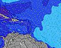 |  | |||||||||||||||
Oleaje Altura (m) Dirección Período (s) | ENE 7 | ENE 7 | E 7 | NE 7 | NE 7 | NNE 7 | ENE 8 | E 8 | E 4 | E 4 | E 4 | NE 11 | NE 11 | N 11 | ESE 5 | NE 8 | NE 8 | NE 10 | E 5 | NE 9 | NE 9 | E 7 | N 7 | N 7 |
Gráfico Olas | ||||||||||||||||||||||||
0 | 0 | 0 | 11 | 11 | 9 | 0 | 0 | 27 | 36 | 0 | 5 | 5 | 2 | 0 | 10 | 9 | 4 | 0 | 13 | 3 | 0 | 1 | 1 | |
Viento (km/h) | ||||||||||||||||||||||||
Estado del Viento Viento de Mar Viento de Mar-Cruzado Cruzado Viento de Tierra-Cruzado Viento de Tierra Cristalino | cross | cross | cross | cross-off | cross-off | cross-off | cross-off | cross-off | cross | cross | cross-off | cross-off | cross-off | cross-off | cross-off | cross | cross | cross | cross-off | cross-off | cross-off | cross-off | cross | cross |
Marea alta | 8:38PM0.38m | 9:11PM0.39m | 6:27AM0.19m | 9:41PM0.39m | ||||||||||||||||||||
Marea baja | 12:17PM0.02m | 1:00PM0.03m | 4:20AM0.19m | 1:42PM0.05m | ||||||||||||||||||||
— | 5:56 | — | — | — | — | — | — | — | 5:56 | — | — | — | — | — | — | — | 5:56 | — | — | — | — | — | — | |
— | — | — | — | — | 6:55 | — | — | — | — | — | — | — | 6:55 | — | — | — | — | — | — | — | 6:54 | — | — | |
mm | — | — | — | 1 | — | — | — | 1 | 1 | 1 | 1 | — | — | — | — | — | — | — | — | — | — | — | — | — |
Temp. °C | 27 | 27 | 27 | 27 | 28 | 28 | 27 | 27 | 27 | 27 | 28 | 28 | 28 | 28 | 28 | 28 | 27 | 27 | 27 | 27 | 27 | 28 | 27 | 27 |
Enfriamiento °C | 28 | 27 | 27 | 27 | 29 | 29 | 28 | 27 | 27 | 27 | 28 | 28 | 28 | 28 | 29 | 29 | 26 | 26 | 26 | 25 | 25 | 27 | 25 | 25 |
Oleaje 1 Altura (m) Dirección Período (s) | SE 5 | SE 8 | — | NE 7 | NE 7 | NNE 7 | ENE 8 | — | — | E 9 | ENE 8 | ENE 8 | ENE 8 | NE 8 | NE 9 | NE 8 | NE 8 | NE 10 | NE 9 | NE 9 | NE 9 | — | N 7 | N 7 |
5 | 14 | — | 11 | 11 | 9 | 56 | — | — | 2 | 22 | 13 | 13 | 17 | 22 | 10 | 9 | 4 | 22 | 13 | 3 | — | 1 | 1 | |
Oleaje 2 Altura (m) Dirección Período (s) | — | — | — | — | — | NE 5 | — | — | — | — | — | NE 11 | NE 11 | E 9 | E 9 | NE 10 | NE 10 | — | — | — | — | — | — | — |
— | — | — | — | — | 5 | — | — | — | — | — | 5 | 5 | 2 | 2 | 4 | 4 | — | — | — | — | — | — | — | |
Oleaje 3 Altura (m) Dirección Período (s) | — | — | — | — | — | — | — | — | — | — | — | — | N 11 | N 11 | — | — | — | — | — | — | — | — | — | — |
— | — | — | — | — | — | — | — | — | — | — | — | 2 | 2 | — | — | — | — | — | — | — | — | — | — | |
Olas de Viento Altura (m) Dirección Período (s) | ENE 7 | ENE 7 | E 7 | E 8 | E 8 | E 8 | SE 4 | E 8 | E 4 | E 4 | E 4 | ESE 5 | ESE 5 | ESE 5 | ESE 5 | E 5 | E 5 | E 5 | E 5 | ESE 5 | E 6 | E 7 | E 7 | E 7 |
74 | 86 | 81 | 84 | 84 | 82 | 7 | 102 | 27 | 36 | 31 | 35 | 44 | 41 | 50 | 47 | 51 | 57 | 73 | 113 | 160 | 202 | 214 | 218 | |
Viento del Tierra o Mar Limpio más proximo | ||||||||||||||||||||||||
Distancia (km) | 112 | 112 | 73 | 73 | 73 | 73 | 73 | 109 | 103 | 103 | 114 | 228 | 1376 | 176 | 174 | 112 | 174 | 378 | 522 | 872 | 112 | 241 | 231 | 522 |
Mejores Olas Previstas en Saint Thomas | ||||||||||||||||||||||||
Mejores Olas Previstas en US Virgin Islands | ||||||||||||||||||||||||
Busca-Olas Global | ||||||||||||||||||||||||
- Map Icons:
 Break
Break Live Wave Height (m)
 Live Wind Speed (km/h)
 Surf Rating (10 Max)
 Ocean Swells (m)
- Wind Speed (km/h)
GRÁTIS! Un widget de Surf-Forecast.com para tu sitio
Este widget grátis de previsiones de surf y tiempo puede ser añadido a cualquier otro sitio y da un resumen de previsiones de olas para Caret Bay. Solo necesita cortar y pegar el código HTML de abajo en su web. Puede elegir preferencias de idioma y de unidades (métricas o imperiales) para convenir a los usuarios de su sitio. Clica aquí para obtener el código.
 Nearest