
Previsiones:

Pronóstico Corto PlazoLluvia ligera (totál 5mm), cayendo mayormente el miércoles por la noche. Warm (max 26°C el lunes por la tarde, min 25°C el martes por la mañana). Mayormente vientos frescos. | ||||||||||||||||||||
lun 3 | martes 4 | miércoles 5 | ||||||||||||||||||
1 PM | 4 PM | 7 PM | 10 PM | 1 AM | 4 AM | 7 AM | 10 AM | 1 PM | 4 PM | 7 PM | 10 PM | 1 AM | 4 AM | 7 AM | 10 AM | 1 PM | 4 PM | 7 PM | 10 PM | |
Mapa de Altura de Olas | 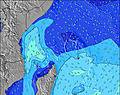 | 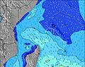 | 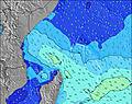 | 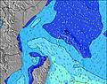 | 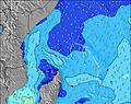 | 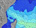 | 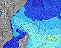 | 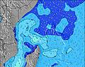 | ||||||||||||
Oleaje Altura (m) Dirección Período (s) | ESE 9 | ESE 9 | ESE 9 | ESE 9 | SE 9 | SE 8 | SE 10 | SE 9 | SE 9 | SE 9 | SE 9 | SE 9 | SE 9 | NE 10 | NE 10 | ESE 9 | SSE 9 | SE 9 | SE 9 | SSE 9 |
Gráfico Olas | ||||||||||||||||||||
0 | 0 | 0 | 0 | 0 | 0 | 0 | 0 | 0 | 0 | 0 | 0 | 0 | 4 | 4 | 0 | 0 | 0 | 0 | 0 | |
Viento (km/h) | ||||||||||||||||||||
Estado del Viento Viento de Mar Viento de Mar-Cruzado Cruzado Viento de Tierra-Cruzado Viento de Tierra Cristalino | cross-off | cross-off | cross-off | cross-off | cross-off | cross-off | cross-off | cross-off | cross-off | cross-off | cross-off | cross-off | cross-off | cross-off | cross-off | cross-off | cross-off | cross-off | cross-off | cross-off |
Marea alta | 7:26PM1.17m | 8:11AM1.25m | 7:58PM1.04m | 8:52AM1.26m | 8:36PM0.90m | |||||||||||||||
Marea baja | 1:34PM0.30m | 1:43AM0.11m | 2:19PM0.35m | 2:10AM0.14m | 3:15PM0.40m | |||||||||||||||
— | — | — | — | — | 6:26 | — | — | — | — | — | — | — | 6:26 | — | — | — | — | — | — | |
— | 6:22 | — | — | — | — | — | — | — | 6:22 | — | — | — | — | — | — | — | 6:22 | — | — | |
mm | — | — | — | — | — | — | — | — | — | — | — | — | — | — | — | — | — | — | — | — |
Temp. °C | 26 | 26 | 26 | 26 | 26 | 26 | 26 | 25 | 26 | 26 | 26 | 26 | 25 | 25 | 26 | 26 | 26 | 26 | 26 | 26 |
Enfriamiento °C | 27 | 27 | 27 | 27 | 26 | 25 | 25 | 23 | 24 | 24 | 24 | 25 | 23 | 24 | 25 | 26 | 26 | 26 | 25 | 25 |
Oleaje 1 Altura (m) Dirección Período (s) | ESE 9 | SSE 8 | SSE 8 | ESE 9 | SSW 16 | S 10 | S 21 | S 20 | S 19 | S 19 | SSW 18 | SSW 18 | SSW 17 | SSW 17 | SSW 16 | ESE 9 | ESE 8 | SSW 15 | SSW 15 | ESE 8 |
92 | 99 | 96 | 119 | 80 | 51 | 76 | 121 | 184 | 177 | 104 | 103 | 59 | 54 | 51 | 199 | 154 | 23 | 42 | 147 | |
Oleaje 2 Altura (m) Dirección Período (s) | SSW 14 | ESE 9 | ESE 9 | SSE 8 | S 17 | SSW 15 | SSW 15 | WSW 7 | WSW 7 | WSW 7 | SE 19 | SSE 18 | SSE 18 | SSE 18 | SSE 17 | SSW 16 | SSW 16 | SSE 16 | SE 16 | S 15 |
41 | 94 | 119 | 96 | 22 | 45 | 43 | 10 | 5 | 5 | 92 | 63 | 61 | 60 | 29 | 50 | 49 | 25 | 9 | 38 | |
Oleaje 3 Altura (m) Dirección Período (s) | SSW 18 | SSE 16 | SSW 17 | SSW 16 | S 22 | WSW 7 | WSW 7 | SSW 14 | SSW 14 | SSW 14 | WSW 7 | WSW 7 | WSW 7 | NE 10 | NE 10 | SSE 16 | SSE 16 | WSW 8 | SW 8 | SW 7 |
60 | 53 | 95 | 86 | 36 | 5 | 5 | 20 | 20 | 20 | 5 | 4 | 4 | 4 | 4 | 26 | 26 | 6 | 2 | 2 | |
Olas de Viento Altura (m) Dirección Período (s) | SSE 8 | — | — | — | SE 9 | SE 8 | SE 10 | SE 9 | SE 9 | SE 9 | SE 9 | SE 9 | SE 9 | SE 9 | SE 9 | SSE 9 | SSE 9 | SE 9 | SE 9 | SSE 9 |
99 | — | — | — | 257 | 216 | 489 | 632 | 750 | 699 | 636 | 593 | 549 | 537 | 457 | 222 | 218 | 412 | 421 | 280 | |
Viento del Tierra o Mar Limpio más proximo | ||||||||||||||||||||
Distancia (km) | 20 | 20 | 1815 | 1821 | 1770 | 1741 | 1766 | 1793 | 1793 | 1793 | 1770 | 1770 | 1770 | 1770 | 20 | 1781 | 1793 | 1821 | 1770 | 1770 |
Mejores Olas Previstas en Mahe | ||||||||||||||||||||
Mejores Olas Previstas en Seychelles | ||||||||||||||||||||
Busca-Olas Global | ||||||||||||||||||||
- Map Icons:
 Break
Break Live Wave Height (m)
 Live Wind Speed (km/h)
 Surf Rating (10 Max)
 Ocean Swells (m)
- Wind Speed (km/h)
GRÁTIS! Un widget de Surf-Forecast.com para tu sitio
Este widget grátis de previsiones de surf y tiempo puede ser añadido a cualquier otro sitio y da un resumen de previsiones de olas para Carana. Solo necesita cortar y pegar el código HTML de abajo en su web. Puede elegir preferencias de idioma y de unidades (métricas o imperiales) para convenir a los usuarios de su sitio. Clica aquí para obtener el código.
 Nearest