
Previsiones:

Pronóstico Corto PlazoMayormente seco. Warm (max 20°C el martes por la mañana, min 12°C el domingo por la noche). Vientos decreciente (vientos frescos desde el NNO el lunes por la tarde, Vientos ligeros desde el NNE por la mañana de martes). | ||||||||||||||||||
dom 2 | lunes 3 | martes 4 | ||||||||||||||||
8 PM | 11 PM | 2 AM | 5 AM | 8 AM | 11 AM | 2 PM | 5 PM | 8 PM | 11 PM | 2 AM | 5 AM | 8 AM | 11 AM | 2 PM | 5 PM | 8 PM | 11 PM | |
Mapa de Altura de Olas |  | |  |  |  | 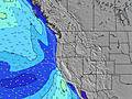 |  | |||||||||||
Oleaje Altura (m) Dirección Período (s) | WNW 9 | WNW 9 | WNW 8 | WNW 8 | WNW 8 | WNW 8 | NW 8 | NW 6 | NW 7 | NW 7 | NW 7 | NW 7 | NW 7 | NW 7 | NW 7 | NW 7 | NW 7 | NW 7 |
Gráfico Olas | ||||||||||||||||||
405 | 352 | 284 | 232 | 197 | 153 | 164 | 181 | 215 | 183 | 168 | 168 | 153 | 153 | 153 | 206 | 218 | 225 | |
Viento (km/h) | ||||||||||||||||||
Estado del Viento Viento de Mar Viento de Mar-Cruzado Cruzado Viento de Tierra-Cruzado Viento de Tierra Cristalino | cross-off | cross-off | cross-off | cross-off | cross-off | cross | cross | cross | cross-off | cross-off | cross-off | cross-off | cross-off | cross | cross | cross | cross-off | cross-off |
Marea alta | 3:34AM2.66m | 4:13PM2.99m | 4:26AM2.47m | 4:48PM3.02m | ||||||||||||||
Marea baja | 9:47PM1.19m | 9:44AM0.90m | 10:36PM1.10m | 10:16AM1.12m | ||||||||||||||
— | — | — | 6:01 | — | — | — | — | — | — | — | 6:03 | — | — | — | — | — | — | |
8:42 | — | — | — | — | — | — | — | 8:40 | — | — | — | — | — | — | — | 8:38 | — | |
mm | — | — | — | — | — | — | — | — | — | — | — | — | — | — | — | — | — | — |
Temp. °C | 15 | 14 | 12 | 12 | 12 | 17 | 18 | 18 | 17 | 16 | 16 | 16 | 17 | 20 | 20 | 19 | 17 | 16 |
Enfriamiento °C | 11 | 11 | 9 | 10 | 10 | 13 | 13 | 13 | 13 | 12 | 13 | 14 | 15 | 17 | 17 | 16 | 14 | 14 |
Oleaje 1 Altura (m) Dirección Período (s) | WNW 9 | WNW 9 | WNW 8 | WNW 8 | WNW 8 | WNW 8 | WSW 13 | SW 13 | SW 13 | NW 7 | NW 7 | NW 7 | NW 7 | NW 7 | NW 7 | WNW 10 | WNW 9 | NW 7 |
405 | 352 | 284 | 232 | 197 | 153 | 17 | 7 | 7 | 183 | 168 | 168 | 153 | 153 | 153 | 19 | 33 | 225 | |
Oleaje 2 Altura (m) Dirección Período (s) | SW 13 | SW 13 | SW 13 | SW 13 | SW 13 | WSW 13 | WSW 18 | SW 17 | WSW 16 | WSW 16 | WSW 16 | WSW 16 | WSW 16 | WSW 16 | WNW 10 | WSW 16 | WSW 16 | WNW 9 |
28 | 28 | 28 | 28 | 27 | 17 | 30 | 12 | 26 | 25 | 25 | 25 | 25 | 25 | 10 | 25 | 24 | 28 | |
Oleaje 3 Altura (m) Dirección Período (s) | SW 18 | WSW 18 | WSW 18 | WSW 18 | WSW 18 | WSW 18 | — | — | — | SW 13 | SW 13 | SW 13 | SW 13 | SW 13 | WSW 16 | SW 12 | SW 12 | WSW 15 |
12 | 31 | 31 | 31 | 31 | 30 | — | — | — | 7 | 7 | 7 | 7 | 6 | 25 | 6 | 6 | 23 | |
Olas de Viento Altura (m) Dirección Período (s) | — | — | — | — | — | — | NW 8 | NW 6 | NW 7 | — | — | — | — | — | — | NW 7 | NW 7 | — |
— | — | — | — | — | — | 164 | 181 | 215 | — | — | — | — | — | — | 206 | 218 | — | |
Viento del Tierra o Mar Limpio más proximo | ||||||||||||||||||
Distancia (km) | 671 | 314 | 43 | 43 | 43 | 170 | 336 | 340 | 345 | 336 | 43 | 43 | 43 | 170 | 226 | 340 | 381 | 66 |
Mejores Olas Previstas en North Oregon | ||||||||||||||||||
Mejores Olas Previstas en United States | ||||||||||||||||||
Busca-Olas Global | ||||||||||||||||||
- Map Icons:
 Break
Break Live Wave Height (m)
 Live Wind Speed (km/h)
 Surf Rating (10 Max)
 Ocean Swells (m)
- Wind Speed (km/h)
GRÁTIS! Un widget de Surf-Forecast.com para tu sitio
Este widget grátis de previsiones de surf y tiempo puede ser añadido a cualquier otro sitio y da un resumen de previsiones de olas para Cape Lookout. Solo necesita cortar y pegar el código HTML de abajo en su web. Puede elegir preferencias de idioma y de unidades (métricas o imperiales) para convenir a los usuarios de su sitio. Clica aquí para obtener el código.
 Nearest