
Previsiones:

Pronóstico Corto PlazoFuerte lluvia (totál 63mm), más pesada durante la noche de domingo. Warm (max 29°C el domingo por la tarde, min 24°C el domingo por la noche). El viento será generalmente ligero. | |||||||||||||||||||
dom 2 | lunes 3 | martes 4 | |||||||||||||||||
3 PM | 6 PM | 9 PM | 12 AM | 3 AM | 6 AM | 9 AM | 12 PM | 3 PM | 6 PM | 9 PM | 12 AM | 3 AM | 6 AM | 9 AM | 12 PM | 3 PM | 6 PM | 9 PM | |
Mapa de Altura de Olas |  |  | 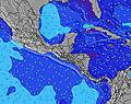 |  |  | 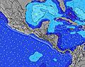 |  | ||||||||||||
Oleaje Altura (m) Dirección Período (s) | SSW 12 | SW 15 | SW 15 | SSW 12 | SSW 12 | SSW 12 | SSW 12 | SSW 11 | SSW 11 | SSW 11 | SSW 10 | SSW 10 | SSW 9 | SSW 9 | SSW 9 | SSW 9 | SSW 8 | SSW 8 | SSW 8 |
Gráfico Olas | |||||||||||||||||||
193 | 104 | 104 | 102 | 97 | 99 | 91 | 167 | 202 | 202 | 166 | 201 | 134 | 134 | 134 | 137 | 113 | 99 | 110 | |
Viento (km/h) | |||||||||||||||||||
Estado del Viento Viento de Mar Viento de Mar-Cruzado Cruzado Viento de Tierra-Cruzado Viento de Tierra Cristalino | cross | off | cross-off | cross-off | cross-off | glassy | glassy | cross-on | cross-on | glassy | glassy | glassy | cross-off | cross-off | glassy | cross-on | cross-on | cross | cross-on |
Marea alta | 5:12PM2.75m | 5:36AM2.90m | 5:50PM2.68m | 6:13AM2.88m | 6:32PM2.59m | ||||||||||||||
Marea baja | 11:19PM0.39m | 11:48AM0.49m | 11:55PM0.45m | 12:28PM0.51m | |||||||||||||||
— | — | — | — | 5:24 | — | — | — | — | — | — | — | 5:24 | — | — | — | — | — | — | |
5:52 | — | — | — | — | — | — | — | 5:52 | — | — | — | — | — | — | — | 5:52 | — | — | |
mm | 4 | 14 | 24 | 2 | — | — | — | — | — | 4 | 3 | — | — | — | 1 | — | 1 | 3 | 5 |
Temp. °C | 29 | 26 | 24 | 24 | 25 | 25 | 27 | 29 | 29 | 28 | 27 | 27 | 26 | 26 | 28 | 29 | 29 | 28 | 27 |
Enfriamiento °C | 33 | 29 | 27 | 26 | 29 | 29 | 32 | 33 | 32 | 33 | 31 | 32 | 30 | 30 | 33 | 33 | 32 | 33 | 31 |
Oleaje 1 Altura (m) Dirección Período (s) | SSW 12 | SSW 6 | SSW 12 | SSW 7 | SSW 7 | SSW 8 | SSW 8 | SSW 11 | SSW 11 | SSW 11 | SSW 10 | SSW 10 | SSW 9 | SSW 9 | SSW 9 | SSW 9 | SSW 8 | SSW 8 | SSW 8 |
193 | 22 | 94 | 54 | 54 | 58 | 58 | 167 | 202 | 202 | 166 | 201 | 134 | 134 | 134 | 137 | 113 | 99 | 110 | |
Oleaje 2 Altura (m) Dirección Período (s) | SW 15 | SSW 12 | SSW 7 | SSW 12 | SSW 12 | SSW 12 | SSW 12 | SW 13 | SW 13 | WSW 13 | SW 13 | SW 13 | SSW 13 | SSW 13 | SW 12 | SW 12 | SW 9 | SW 12 | SSW 12 |
104 | 93 | 36 | 96 | 96 | 99 | 91 | 88 | 87 | 69 | 85 | 44 | 66 | 65 | 74 | 39 | 22 | 38 | 59 | |
Oleaje 3 Altura (m) Dirección Período (s) | S 11 | SW 15 | SW 15 | SW 14 | SW 14 | WSW 14 | SSW 14 | SW 13 | SSW 13 | SW 13 | SW 13 | SW 13 | SW 13 | SW 13 | SW 13 | SW 12 | SW 12 | SW 9 | SW 12 |
21 | 104 | 104 | 102 | 97 | 71 | 80 | 44 | 69 | 44 | 44 | 44 | 42 | 41 | 40 | 37 | 37 | 22 | 37 | |
Olas de Viento Altura (m) Dirección Período (s) | — | — | — | — | — | — | — | — | — | — | — | — | — | — | — | — | — | — | — |
— | — | — | — | — | — | — | — | — | — | — | — | — | — | — | — | — | — | — | |
Viento del Tierra o Mar Limpio más proximo | |||||||||||||||||||
Distancia (km) | 101 | 0 | 0 | 0 | 0 | 0 | 0 | 159 | 113 | 0 | 0 | 0 | 0 | 0 | 0 | 162 | 162 | 4 | 1 |
Mejores Olas Previstas en Golfo Dulce | |||||||||||||||||||
Mejores Olas Previstas en Costa Rica | |||||||||||||||||||
Busca-Olas Global | |||||||||||||||||||
- Map Icons:
 Break
Break Live Wave Height (m)
 Live Wind Speed (km/h)
 Surf Rating (10 Max)
 Ocean Swells (m)
- Wind Speed (km/h)
GRÁTIS! Un widget de Surf-Forecast.com para tu sitio
Este widget grátis de previsiones de surf y tiempo puede ser añadido a cualquier otro sitio y da un resumen de previsiones de olas para Cabo Matapalo. Solo necesita cortar y pegar el código HTML de abajo en su web. Puede elegir preferencias de idioma y de unidades (métricas o imperiales) para convenir a los usuarios de su sitio. Clica aquí para obtener el código.
 Nearest