

Bonnet Shores Point Surf Guide
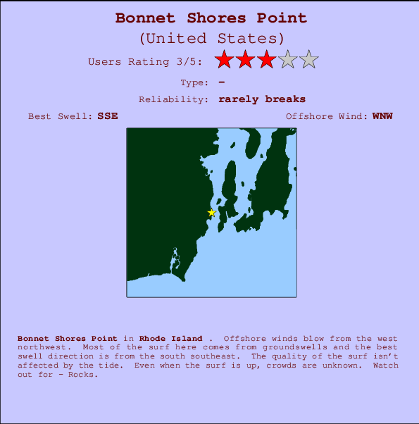
Bonnet Shores Point in Rhode Island is a fairly exposed point break Offshore winds are from the west northwest. Windswells and groundswells in equal measure and the ideal swell direction is from the south southeast. Good surf at all stages of the tide. The location means that it never gets crowded. Take care of - Rocks.
Bonnet Shores Point Spot Info
| Type: | Rating: | Reliability: | Todays Sea Temp*: |
|---|---|---|---|
| rarely breaks | 22.0°C*ocean temperature recorded from satellite |
Surfing Bonnet Shores Point:
The best conditions reported for surf at Bonnet Shores Point occur when a South-southeast swell combines with an offshore wind direction from the West-northwest.

Energía de Olas (poder): 12 horas


Bonnet Shores Point Surf:
Thursday, 16 July 2026, 03:03 Local time| miércoles 15 | jue | |||
| 5PM | 8PM | 11PM | 2AM | |
| Wave (m) | ||||
| Período (s) | 17 | 6 | 6 | 6 |
| Viento (km/h) | ||||
| Estado del Viento | off | cross- off |
cross- off |
off |
- /breaks/Bonnet-Shores-Point/forecasts/latest
Bonnet Shores Point Surf Guide
Bonnet Shores Point in Rhode Island is a fairly exposed point break Offshore winds are from the west northwest. Windswells and groundswells in equal measure and the ideal swell direction is from the south southeast. Good surf at all stages of the tide. The location means that it never gets crowded. Take care of - Rocks.
Bonnet Shores Point Spot Info
Type: Rating: Reliability: Todays Sea Temp*:  Point
Point 3
3rarely breaks 22.0°C*ocean temperature recorded from satelliteSurfing Bonnet Shores Point:
The best conditions reported for surf at Bonnet Shores Point occur when a South-southeast swell combines with an offshore wind direction from the West-northwest.
Energía de Olas (poder): 12 horas
Usa la barra de navegación de arriba para ver la temperatura del mar en Bonnet Shores Point, fotografías Bonnet Shores Point, previsiones detalladas de olas para Bonnet Shores Point, vientos y previsión del tiempo, webcams para Bonnet Shores Point, viento actual desde estaciones meteorológicas en Rhode Island y predicciones de marea para Bonnet Shores Point. Las mapas de olas para United States enseñarán un mapa grande de United States y los mares que rodean. Los mapas de olas pueden ser animadas para mostrar diferentes componentes de olas, la altura de ola, la energía de ola, el período, junto con previsiones de viento y del tiempo. Previsiones actuales del tiempo y del estado del mar provienen de boyas marinas de United States, del barcos que transitan en la zona y de estaciones meteorológicas costeras. Cada página de previsiones tiene un Busca-Olas Regional y Global para localizar las mejores condiciones para surfear en el área de Bonnet Shores Point.
Bonnet Shores Point Surf:
Thursday, 16 July 2026, 03:03 Local timemiércoles 15 jue 5PM 8PM 11PM 2AM Wave (m) Período (s) 17 6 6 6 Viento (km/h) Estado del Viento off cross-
offcross-
offoff - /breaks/Bonnet-Shores-Point/forecasts/latest
- /breaks/Bonnet-Shores-Point/forecasts/latest/six_day
Bonnet Shores Point Surf Guide
Bonnet Shores Point in Rhode Island is a fairly exposed point break Offshore winds are from the west northwest. Windswells and groundswells in equal measure and the ideal swell direction is from the south southeast. Good surf at all stages of the tide. The location means that it never gets crowded. Take care of - Rocks.
Bonnet Shores Point Spot Info
Type: Rating: Reliability: Todays Sea Temp*: Point3rarely breaks 22.0°C*ocean temperature recorded from satelliteSurfing Bonnet Shores Point:
The best conditions reported for surf at Bonnet Shores Point occur when a South-southeast swell combines with an offshore wind direction from the West-northwest.
Energía de Olas (poder): 12 horas
Usa la barra de navegación de arriba para ver la temperatura del mar en Bonnet Shores Point, fotografías Bonnet Shores Point, previsiones detalladas de olas para Bonnet Shores Point, vientos y previsión del tiempo, webcams para Bonnet Shores Point, viento actual desde estaciones meteorológicas en Rhode Island y predicciones de marea para Bonnet Shores Point. Las mapas de olas para United States enseñarán un mapa grande de United States y los mares que rodean. Los mapas de olas pueden ser animadas para mostrar diferentes componentes de olas, la altura de ola, la energía de ola, el período, junto con previsiones de viento y del tiempo. Previsiones actuales del tiempo y del estado del mar provienen de boyas marinas de United States, del barcos que transitan en la zona y de estaciones meteorológicas costeras. Cada página de previsiones tiene un Busca-Olas Regional y Global para localizar las mejores condiciones para surfear en el área de Bonnet Shores Point.
Bonnet Shores Point Surf:
Thursday, 16 July 2026, 03:03 Local timemiércoles 15 jue 5PM 8PM 11PM 2AM Wave (m) Período (s) 17 6 6 6 Viento (km/h) Estado del Viento off cross-
offcross-
offoff - /breaks/Bonnet-Shores-Point/forecasts/latest
Bonnet Shores Point Surf Guide
Bonnet Shores Point in Rhode Island is a fairly exposed point break Offshore winds are from the west northwest. Windswells and groundswells in equal measure and the ideal swell direction is from the south southeast. Good surf at all stages of the tide. The location means that it never gets crowded. Take care of - Rocks.
Bonnet Shores Point Spot Info
Type: Rating: Reliability: Todays Sea Temp*: Point3rarely breaks 22.0°C*ocean temperature recorded from satelliteSurfing Bonnet Shores Point:
The best conditions reported for surf at Bonnet Shores Point occur when a South-southeast swell combines with an offshore wind direction from the West-northwest.
Energía de Olas (poder): 12 horas
Usa la barra de navegación de arriba para ver la temperatura del mar en Bonnet Shores Point, fotografías Bonnet Shores Point, previsiones detalladas de olas para Bonnet Shores Point, vientos y previsión del tiempo, webcams para Bonnet Shores Point, viento actual desde estaciones meteorológicas en Rhode Island y predicciones de marea para Bonnet Shores Point. Las mapas de olas para United States enseñarán un mapa grande de United States y los mares que rodean. Los mapas de olas pueden ser animadas para mostrar diferentes componentes de olas, la altura de ola, la energía de ola, el período, junto con previsiones de viento y del tiempo. Previsiones actuales del tiempo y del estado del mar provienen de boyas marinas de United States, del barcos que transitan en la zona y de estaciones meteorológicas costeras. Cada página de previsiones tiene un Busca-Olas Regional y Global para localizar las mejores condiciones para surfear en el área de Bonnet Shores Point.
Bonnet Shores Point Surf:
Thursday, 16 July 2026, 03:03 Local timemiércoles 15 jue 5PM 8PM 11PM 2AM Wave (m) Período (s) 17 6 6 6 Viento (km/h) Estado del Viento off cross-
offcross-
offoff Tide Times:
Para Watson Pier, Boston Neck, Narragansett Bay, Rhode Island, a %{dist} %{km} de %{location}.
PROXIMA ES A LAS (hora local) quedan marea alta marea baja Bonnet Shores Point Tide Times and Tide Chart
Live Weather:
At BUOY-NWPR1, 8 km from Bonnet Shores Point.
light winds from the NW
(km/h)Air temperature
23.6°CCurrent weather near Bonnet Shores Point
Buoy Data:
At Block Island, RI, 39 miles from Bonnet Shores Point.
9PM 10PM 11PM 12AM Antigüedad de datos 4 hr 3 hr 2 hr 1 hr Altura de Olas (m) 


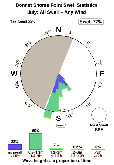
Período Dominante (s) 6 6 7 6 Overall Bonnet Shores Point Surf Consistency and Wind Distribution in julio
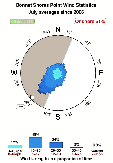


Wind stats for Bonnet Shores Point: see the variation in direction and stength by month.
Fotos de Surf
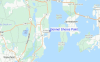
de la galeríaContornos: Carreteras y Ríos: Selecciona un spot desde el menú 


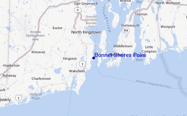
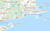
Usa este mapa para navegar hacia las playas de surf de Rhode Island y estaciones de marea cercanas de Bonnet Shores Point
Spots de Surf más cercanos a Bonnet Shores Point:
(Clica la ubicación para más detalles)- Closest spot1 mi
- Second closest spot4 mi
- Third closest spot4 mi
- Fourth closest spot5 mi
- Fifth closest spot6 mi
Boyas marinas más cercanas a Bonnet Shores Point:
- Closest Boya Marinas39 mi
- Second closest Boya Marinas62 mi
- Third closest Boya Marinas63 mi
- Fourth closest Boya Marinas64 mi
- Fifth closest Boya Marinas69 mi
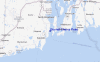
Estaciones de marea más cercanas a Bonnet Shores Point:
- Closest estación de mareaWatson Pier, Boston Neck, Narragansett Bay2 mi
- Second closest estación de mareaWest Jamestown, Dutch Island Harbor, Conanicut Island2 mi
- Third closest estación de mareaBeavertail Point, Narragansett Bay2 mi
- Fourth closest estación de mareaCastle Hill, Narragansett Bay3 mi
- Fifth closest estación de mareaNarragansett Pier, Narragansett Bay4 mi
Airports
- The closest passenger airport to Bonnet Shores Point is Theodore Francis Green State (Providence) Airport (PVD) in USA, 27 km (17 miles) away (directly).
- The second nearest airport to Bonnet Shores Point is North Central State (Smithfield) Airport (SFZ), also in USA, 49 km (30 miles) away.
- Third is Otis Angb (Falmouth) Airport (FMH) in USA, 77 km (48 miles) away.
- General Edward Lawrence Logan International (Boston) Airport (BOS) in USA is 104 km (65 miles) away.
- Hartford Brainard Airport (HFD), also in USA is the fifth nearest airport to Bonnet Shores Point and is 106 km (66 miles) away.
- /breaks/Bonnet-Shores-Point/forecasts/latest
 Nearest