
Previsiones:

Pronóstico Corto PlazoMayormente seco. Warm (max 23°C el martes por la mañana, min 11°C el domingo por la noche). El viento será generalmente ligero. | ||||||||||||||||||||
sáb 1 | domingo 2 | lunes 3 | ||||||||||||||||||
2 PM | 5 PM | 8 PM | 11 PM | 2 AM | 5 AM | 8 AM | 11 AM | 2 PM | 5 PM | 8 PM | 11 PM | 2 AM | 5 AM | 8 AM | 11 AM | 2 PM | 5 PM | 8 PM | 11 PM | |
Mapa de Altura de Olas |  |  | 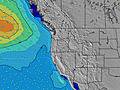 | 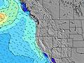 |  |  | 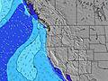 | 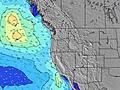 | ||||||||||||
Oleaje Altura (m) Dirección Período (s) | WNW 8 | WNW 8 | WNW 8 | WNW 8 | WNW 8 | WNW 8 | WNW 9 | WNW 9 | WNW 9 | WNW 9 | WNW 9 | WNW 9 | WNW 8 | WNW 8 | NW 8 | NW 8 | NW 7 | NW 7 | NW 7 | SW 13 |
Gráfico Olas | ||||||||||||||||||||
159 | 173 | 143 | 169 | 186 | 291 | 363 | 436 | 484 | 415 | 405 | 372 | 277 | 280 | 304 | 244 | 287 | 287 | 323 | 26 | |
Viento (km/h) | ||||||||||||||||||||
Estado del Viento Viento de Mar Viento de Mar-Cruzado Cruzado Viento de Tierra-Cruzado Viento de Tierra Cristalino | cross-on | cross-on | cross-on | on | cross-on | cross-on | glassy | cross-on | cross-on | on | on | on | on | cross-on | on | on | cross-on | on | on | on |
Marea alta | 3:07PM2.22m | 2:39AM2.23m | 3:36PM2.30m | 3:25AM2.06m | 4:08PM2.36m | |||||||||||||||
Marea baja | 8:51PM0.61m | 9:06AM-0.06m | 9:37PM0.50m | 9:37AM0.15m | 10:29PM0.40m | |||||||||||||||
— | — | — | — | — | 6:01 | — | — | — | — | — | — | — | 6:03 | — | — | — | — | — | — | |
— | — | 8:42 | — | — | — | — | — | — | — | 8:40 | — | — | — | — | — | — | — | 8:39 | — | |
mm | — | — | — | — | — | — | — | — | — | — | — | — | — | — | — | — | — | — | — | — |
Temp. °C | 17 | 16 | 16 | 15 | 14 | 13 | 14 | 17 | 17 | 16 | 15 | 13 | 12 | 11 | 12 | 18 | 18 | 18 | 16 | 15 |
Enfriamiento °C | 15 | 14 | 14 | 15 | 14 | 12 | 14 | 15 | 13 | 11 | 11 | 10 | 10 | 8 | 10 | 15 | 14 | 14 | 13 | 13 |
Oleaje 1 Altura (m) Dirección Período (s) | WNW 8 | WNW 8 | WNW 8 | WNW 8 | WNW 8 | WNW 8 | WNW 9 | WNW 9 | WNW 9 | WNW 9 | WNW 9 | WNW 9 | WNW 8 | WNW 8 | NW 8 | SW 13 | SW 13 | SW 13 | SW 13 | SW 13 |
159 | 173 | 143 | 169 | 186 | 291 | 363 | 436 | 484 | 415 | 405 | 372 | 277 | 280 | 304 | 27 | 27 | 27 | 27 | 26 | |
Oleaje 2 Altura (m) Dirección Período (s) | SW 14 | SW 14 | SW 14 | SW 14 | SW 14 | SW 14 | SW 14 | SW 14 | SW 14 | SW 13 | SW 13 | SW 13 | SW 13 | SW 13 | SW 13 | WSW 18 | WSW 18 | WSW 17 | WSW 16 | WSW 16 |
125 | 121 | 119 | 121 | 123 | 121 | 66 | 64 | 64 | 63 | 63 | 62 | 62 | 45 | 44 | 30 | 30 | 28 | 26 | 25 | |
Oleaje 3 Altura (m) Dirección Período (s) | S 8 | W 20 | W 20 | SW 20 | WSW 19 | SW 19 | SW 19 | SW 19 | W 19 | SW 18 | WSW 18 | WSW 18 | WSW 18 | WSW 18 | WSW 18 | — | — | — | — | — |
1 | 8 | 7 | 15 | 37 | 15 | 15 | 15 | 7 | 13 | 31 | 31 | 31 | 31 | 31 | — | — | — | — | — | |
Olas de Viento Altura (m) Dirección Período (s) | — | — | — | — | — | — | — | — | — | N 4 | N 5 | N 5 | N 5 | N 5 | — | NW 8 | NW 7 | NW 7 | NW 7 | NW 7 |
— | — | — | — | — | — | — | — | — | 17 | 55 | 60 | 77 | 47 | — | 244 | 287 | 287 | 323 | 352 | |
Viento del Tierra o Mar Limpio más proximo | ||||||||||||||||||||
Distancia (km) | 793 | 893 | 371 | 10 | 10 | 10 | 10 | 374 | 396 | 1215 | 370 | 370 | 10 | 10 | 10 | 159 | 390 | 396 | 389 | 11 |
Mejores Olas Previstas en North Oregon | ||||||||||||||||||||
Mejores Olas Previstas en United States | ||||||||||||||||||||
Busca-Olas Global | ||||||||||||||||||||
- Map Icons:
 Break
Break Live Wave Height (m)
 Live Wind Speed (km/h)
 Surf Rating (10 Max)
 Ocean Swells (m)
- Wind Speed (km/h)
GRÁTIS! Un widget de Surf-Forecast.com para tu sitio
Este widget grátis de previsiones de surf y tiempo puede ser añadido a cualquier otro sitio y da un resumen de previsiones de olas para Boiler Bay. Solo necesita cortar y pegar el código HTML de abajo en su web. Puede elegir preferencias de idioma y de unidades (métricas o imperiales) para convenir a los usuarios de su sitio. Clica aquí para obtener el código.
 Nearest