
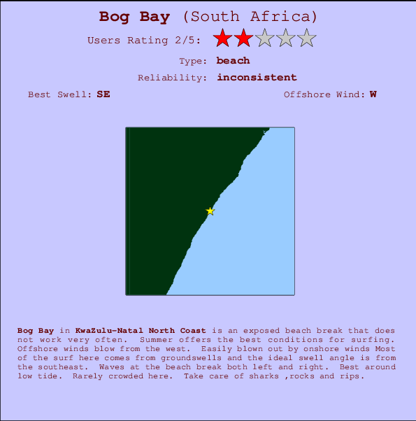
Bog Bay Surf Guide
Bog Bay in Kwazulu-Natal is an exposed beach break that has unreliable waves. Summer offers the best conditions for surfing. The best wind direction is from the west. Light onshore winds ruin the qulaity Tends to receive a mix of groundswells and windswells and the best swell direction is from the southeast. Waves at the beach break both left and right. Best around low tide. Rarely crowded here. Hazards include sharks ,rocks and rips.
Bog Bay Spot Info
| Type: | Rating: | Reliability: | Todays Sea Temp*: |
|---|---|---|---|
| inconsistent | 21.7°C*ocean temperature recorded from satellite |
Surfing Bog Bay:
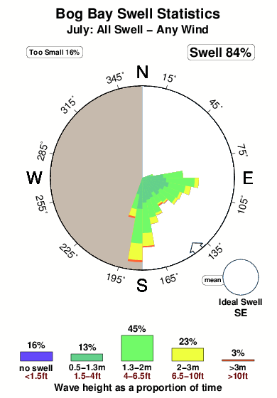
The best conditions reported for surf at Bog Bay occur when a Southeast swell combines with an offshore wind direction from the West.
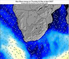
Energía de Olas (poder): 12 horas
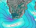

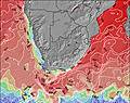
Bog Bay Surf:
Wednesday, 15 July 2026, 10:24 Local time| miércoles 15 | ||||
| 11AM | 2PM | 5PM | 8PM | |
| Wave (m) | ||||
| Período (s) | 10 | 10 | 10 | 11 |
| Viento (km/h) | ||||
| Estado del Viento | cross- on |
cross | cross | cross- off |
- /breaks/Bog-Bay/forecasts/latest
Bog Bay Surf Guide
Bog Bay in Kwazulu-Natal is an exposed beach break that has unreliable waves. Summer offers the best conditions for surfing. The best wind direction is from the west. Light onshore winds ruin the qulaity Tends to receive a mix of groundswells and windswells and the best swell direction is from the southeast. Waves at the beach break both left and right. Best around low tide. Rarely crowded here. Hazards include sharks ,rocks and rips.
Bog Bay Spot Info
Type: Rating: Reliability: Todays Sea Temp*:  Beach
Beach 2
2inconsistent 21.7°C*ocean temperature recorded from satelliteSurfing Bog Bay:
The best conditions reported for surf at Bog Bay occur when a Southeast swell combines with an offshore wind direction from the West.
Energía de Olas (poder): 12 horas
Usa la barra de navegación de arriba para ver la temperatura del mar en Bog Bay, fotografías Bog Bay, previsiones detalladas de olas para Bog Bay, vientos y previsión del tiempo, webcams para Bog Bay, viento actual desde estaciones meteorológicas en KZN North y predicciones de marea para Bog Bay. Las mapas de olas para South Africa enseñarán un mapa grande de South Africa y los mares que rodean. Los mapas de olas pueden ser animadas para mostrar diferentes componentes de olas, la altura de ola, la energía de ola, el período, junto con previsiones de viento y del tiempo. Previsiones actuales del tiempo y del estado del mar provienen de boyas marinas de South Africa, del barcos que transitan en la zona y de estaciones meteorológicas costeras. Cada página de previsiones tiene un Busca-Olas Regional y Global para localizar las mejores condiciones para surfear en el área de Bog Bay.
Bog Bay Surf:
Wednesday, 15 July 2026, 10:24 Local timemiércoles 15 11AM 2PM 5PM 8PM Wave (m) Período (s) 10 10 10 11 Viento (km/h) Estado del Viento cross-
oncross cross cross-
off- /breaks/Bog-Bay/forecasts/latest
- /breaks/Bog-Bay/forecasts/latest/six_day
Bog Bay Surf Guide
Bog Bay in Kwazulu-Natal is an exposed beach break that has unreliable waves. Summer offers the best conditions for surfing. The best wind direction is from the west. Light onshore winds ruin the qulaity Tends to receive a mix of groundswells and windswells and the best swell direction is from the southeast. Waves at the beach break both left and right. Best around low tide. Rarely crowded here. Hazards include sharks ,rocks and rips.
Bog Bay Spot Info
Type: Rating: Reliability: Todays Sea Temp*: Beach2inconsistent 21.7°C*ocean temperature recorded from satelliteSurfing Bog Bay:
The best conditions reported for surf at Bog Bay occur when a Southeast swell combines with an offshore wind direction from the West.
Energía de Olas (poder): 12 horas
Usa la barra de navegación de arriba para ver la temperatura del mar en Bog Bay, fotografías Bog Bay, previsiones detalladas de olas para Bog Bay, vientos y previsión del tiempo, webcams para Bog Bay, viento actual desde estaciones meteorológicas en KZN North y predicciones de marea para Bog Bay. Las mapas de olas para South Africa enseñarán un mapa grande de South Africa y los mares que rodean. Los mapas de olas pueden ser animadas para mostrar diferentes componentes de olas, la altura de ola, la energía de ola, el período, junto con previsiones de viento y del tiempo. Previsiones actuales del tiempo y del estado del mar provienen de boyas marinas de South Africa, del barcos que transitan en la zona y de estaciones meteorológicas costeras. Cada página de previsiones tiene un Busca-Olas Regional y Global para localizar las mejores condiciones para surfear en el área de Bog Bay.
Bog Bay Surf:
Wednesday, 15 July 2026, 10:24 Local timemiércoles 15 11AM 2PM 5PM 8PM Wave (m) Período (s) 10 10 10 11 Viento (km/h) Estado del Viento cross-
oncross cross cross-
off- /breaks/Bog-Bay/forecasts/latest
Bog Bay Surf Guide
Bog Bay in Kwazulu-Natal is an exposed beach break that has unreliable waves. Summer offers the best conditions for surfing. The best wind direction is from the west. Light onshore winds ruin the qulaity Tends to receive a mix of groundswells and windswells and the best swell direction is from the southeast. Waves at the beach break both left and right. Best around low tide. Rarely crowded here. Hazards include sharks ,rocks and rips.
Bog Bay Spot Info
Type: Rating: Reliability: Todays Sea Temp*: Beach2inconsistent 21.7°C*ocean temperature recorded from satelliteSurfing Bog Bay:
The best conditions reported for surf at Bog Bay occur when a Southeast swell combines with an offshore wind direction from the West.
Energía de Olas (poder): 12 horas
Usa la barra de navegación de arriba para ver la temperatura del mar en Bog Bay, fotografías Bog Bay, previsiones detalladas de olas para Bog Bay, vientos y previsión del tiempo, webcams para Bog Bay, viento actual desde estaciones meteorológicas en KZN North y predicciones de marea para Bog Bay. Las mapas de olas para South Africa enseñarán un mapa grande de South Africa y los mares que rodean. Los mapas de olas pueden ser animadas para mostrar diferentes componentes de olas, la altura de ola, la energía de ola, el período, junto con previsiones de viento y del tiempo. Previsiones actuales del tiempo y del estado del mar provienen de boyas marinas de South Africa, del barcos que transitan en la zona y de estaciones meteorológicas costeras. Cada página de previsiones tiene un Busca-Olas Regional y Global para localizar las mejores condiciones para surfear en el área de Bog Bay.
Bog Bay Surf:
Wednesday, 15 July 2026, 10:24 Local timemiércoles 15 11AM 2PM 5PM 8PM Wave (m) Período (s) 10 10 10 11 Viento (km/h) Estado del Viento cross-
oncross cross cross-
offTide Times:
Para Ballitoville, a %{dist} %{km} de %{location}.
PROXIMA ES A LAS (hora local) quedan marea alta marea baja Bog Bay Tide Times and Tide Chart
Live Weather:
At Durban Shaka Airport, 5 km from Bog Bay.
calm
(km/h)Air temperature
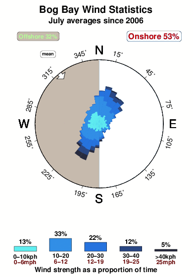
Q1021°COverall Bog Bay Surf Consistency and Wind Distribution in julio
Fotos de Surf
de la galeríaContornos: Carreteras y Ríos: Selecciona un spot desde el menú 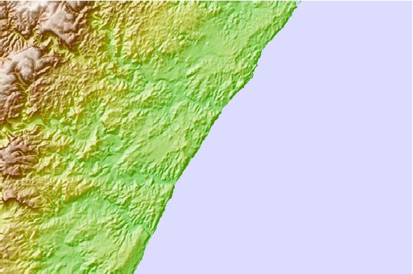
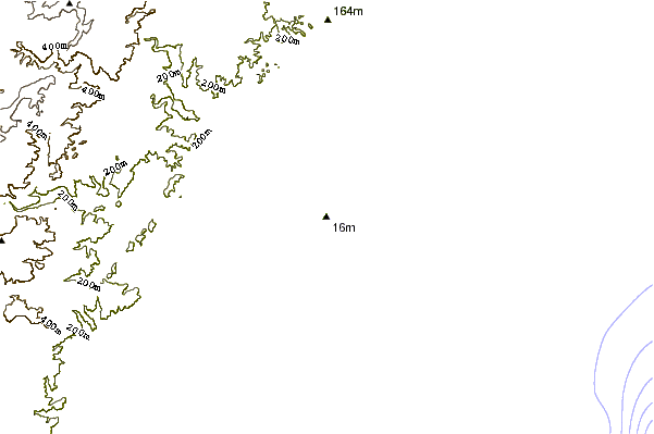
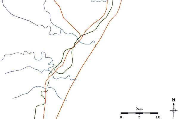
Usa este mapa para navegar hacia las playas de surf de KZN North y estaciones de marea cercanas de Bog Bay
Spots de Surf más cercanos a Bog Bay:
(Clica la ubicación para más detalles)- Closest spot1 mi
- Second closest spot1 mi
- Third closest spot2 mi
- Fourth closest spot2 mi
- Fifth closest spot6 mi
Boyas marinas más cercanas a Bog Bay:
- Closest Boya Marinas2900 mi
- Second closest Boya Marinas4726 mi
- Third closest Boya Marinas5244 mi
- Fourth closest Boya Marinas5265 mi
- Fifth closest Boya Marinas5267 mi
Estaciones de marea más cercanas a Bog Bay:
- Closest estación de mareaBallitoville4 mi
- Second closest estación de mareaDurban20 mi
- Third closest estación de mareaUmkomaas47 mi
- Fourth closest estación de mareaeSikhawini67 mi
- Fifth closest estación de mareaMargate99 mi
Airports
- The closest passenger airport to Bog Bay is Virginia (Durban) Airport (VIR) in South Africa, 22 km (14 miles) away (directly).
- The second nearest airport to Bog Bay is Durban International Airport (DUR), also in South Africa, 46 km (29 miles) away.
- Third is Pietermaritzburg Airport (PZB) in South Africa, 74 km (46 miles) away.
- Richards Bay (Richard's Bay) Airport (RCB) in South Africa is 131 km (81 miles) away.
- Prince Mangosuthu Buthelezi (Ulundi) Airport (ULD), also in South Africa is the fifth nearest airport to Bog Bay and is 144 km (89 miles) away.
- /breaks/Bog-Bay/forecasts/latest


 Nearest