
Previsiones:

Pronóstico Corto PlazoMayormente seco. Warm (max 27°C el lunes por la tarde, min 22°C el martes por la noche). El viento será generalmente ligero. | ||||||||||||||||||||||||
lunes 3 | martes 4 | miércoles 5 | ||||||||||||||||||||||
1 AM | 4 AM | 7 AM | 10 AM | 1 PM | 4 PM | 7 PM | 10 PM | 1 AM | 4 AM | 7 AM | 10 AM | 1 PM | 4 PM | 7 PM | 10 PM | 1 AM | 4 AM | 7 AM | 10 AM | 1 PM | 4 PM | 7 PM | 10 PM | |
Mapa de Altura de Olas |  | 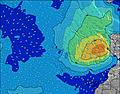 |  |  | 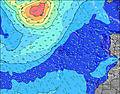 |  |  | 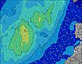 | 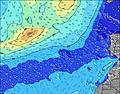 | |||||||||||||||
Oleaje Altura (m) Dirección Período (s) | NNE 6 | NNE 6 | NNE 6 | NNE 7 | NNE 7 | NNE 7 | NNE 7 | NNE 6 | NNE 6 | NNE 6 | NNE 6 | NE 7 | NE 7 | NE 7 | NE 7 | NNE 7 | NNE 7 | NNE 6 | NE 7 | NE 7 | NE 7 | NE 7 | NE 7 | NE 7 |
Gráfico Olas | ||||||||||||||||||||||||
176 | 167 | 149 | 180 | 158 | 170 | 180 | 186 | 170 | 175 | 193 | 192 | 183 | 189 | 194 | 211 | 199 | 222 | 253 | 268 | 287 | 271 | 251 | 251 | |
Viento (km/h) | ||||||||||||||||||||||||
Estado del Viento Viento de Mar Viento de Mar-Cruzado Cruzado Viento de Tierra-Cruzado Viento de Tierra Cristalino | on | cross-on | cross-on | cross-on | cross-on | cross-on | cross-on | cross-on | cross-on | cross-on | cross-on | cross-on | cross-on | cross-on | cross-on | cross-on | cross-on | cross-on | cross-on | cross-on | cross-on | cross-on | cross-on | cross-on |
Marea alta | 4:52AM1.87m | 5:05PM2.00m | 5:32AM1.81m | 5:46PM1.89m | 6:18AM1.73m | 6:38PM1.76m | ||||||||||||||||||
Marea baja | 10:43PM0.21m | 10:48AM0.31m | 11:19PM0.27m | 11:29AM0.39m | 00:01AM0.36m | 12:18PM0.49m | ||||||||||||||||||
— | — | 7:24 | — | — | — | — | — | — | — | 7:26 | — | — | — | — | — | — | — | 7:26 | — | — | — | — | — | |
— | — | — | — | — | — | 8:51 | — | — | — | — | — | — | — | 8:51 | — | — | — | — | — | — | — | 8:50 | — | |
mm | — | — | — | — | — | — | — | — | — | — | — | — | — | — | — | — | — | — | — | — | — | — | — | — |
Temp. °C | 24 | 24 | 24 | 25 | 26 | 27 | 26 | 24 | 24 | 23 | 23 | 24 | 26 | 26 | 26 | 24 | 23 | 23 | 22 | 23 | 24 | 25 | 24 | 23 |
Enfriamiento °C | 23 | 24 | 23 | 24 | 25 | 26 | 25 | 23 | 23 | 22 | 22 | 23 | 26 | 25 | 26 | 24 | 23 | 23 | 21 | 22 | 23 | 24 | 23 | 23 |
Oleaje 1 Altura (m) Dirección Período (s) | WNW 9 | WNW 9 | N 9 | WNW 9 | N 9 | N 9 | WNW 10 | WNW 10 | WNW 9 | WNW 9 | WNW 9 | N 8 | N 8 | WNW 8 | NW 8 | NW 8 | NW 8 | NW 8 | NW 8 | NW 8 | NW 8 | NW 8 | NW 8 | N 11 |
8 | 8 | 27 | 8 | 26 | 26 | 9 | 9 | 9 | 8 | 8 | 12 | 12 | 7 | 11 | 10 | 10 | 10 | 3 | 3 | 2 | 2 | 2 | 10 | |
Oleaje 2 Altura (m) Dirección Período (s) | SSW 13 | SSW 13 | WNW 9 | SSW 12 | SSW 12 | WNW 9 | SSW 12 | S 12 | SSW 12 | SSW 12 | SSW 12 | WNW 9 | WNW 8 | SSW 12 | SW 12 | SSW 12 | S 12 | S 13 | S 11 | SW 13 | SSW 13 | SSW 13 | SW 13 | NW 8 |
17 | 16 | 8 | 15 | 15 | 8 | 15 | 3 | 14 | 14 | 14 | 8 | 7 | 14 | 6 | 14 | 3 | 3 | 2 | 7 | 17 | 17 | 7 | 2 | |
Oleaje 3 Altura (m) Dirección Período (s) | — | — | SSW 12 | S 18 | WNW 9 | SSW 12 | — | S 10 | S 16 | S 16 | S 16 | SSW 12 | SSW 12 | S 15 | S 15 | S 15 | S 15 | W 10 | NW 10 | NW 11 | NW 11 | NW 11 | N 10 | N 10 |
— | — | 15 | 6 | 8 | 15 | — | 2 | 5 | 5 | 5 | 14 | 14 | 4 | 4 | 4 | 4 | 2 | 4 | 5 | 5 | 5 | 2 | 2 | |
Olas de Viento Altura (m) Dirección Período (s) | NNE 6 | NNE 6 | NNE 6 | NNE 7 | NNE 7 | NNE 7 | NNE 7 | NNE 6 | NNE 6 | NNE 6 | NNE 6 | NE 7 | NE 7 | NE 7 | NE 7 | NNE 7 | NNE 7 | NNE 6 | NE 7 | NE 7 | NE 7 | NE 7 | NE 7 | NE 7 |
176 | 167 | 149 | 180 | 158 | 170 | 180 | 186 | 170 | 175 | 193 | 192 | 183 | 189 | 194 | 211 | 199 | 222 | 253 | 268 | 287 | 271 | 251 | 251 | |
Viento del Tierra o Mar Limpio más proximo | ||||||||||||||||||||||||
Distancia (km) | 199 | 62 | 44 | 62 | 62 | 98 | 62 | 62 | 64 | 62 | 64 | 62 | 62 | 104 | 62 | 62 | 79 | 62 | 62 | 62 | 62 | 62 | 62 | 62 |
Mejores Olas Previstas en Gran Canaria | ||||||||||||||||||||||||
Mejores Olas Previstas en Spain (Africa) | ||||||||||||||||||||||||
Busca-Olas Global | ||||||||||||||||||||||||
- Map Icons:
 Break
Break Live Wave Height (m)
 Live Wind Speed (km/h)
 Surf Rating (10 Max)
 Ocean Swells (m)
- Wind Speed (km/h)
GRÁTIS! Un widget de Surf-Forecast.com para tu sitio
Este widget grátis de previsiones de surf y tiempo puede ser añadido a cualquier otro sitio y da un resumen de previsiones de olas para Bocabarranco. Solo necesita cortar y pegar el código HTML de abajo en su web. Puede elegir preferencias de idioma y de unidades (métricas o imperiales) para convenir a los usuarios de su sitio. Clica aquí para obtener el código.
 Nearest