
Previsiones:

Pronóstico Corto PlazoFuerte lluvia (totál 26mm), más pesada durante la noche de domingo. Warm (max 27°C el sábado por la tarde, min 23°C el lunes por la noche). Vientos decreciente (vientos frescos desde el SSO el domingo por la noche, Vientos ligeros desde el ONO por la noche de lunes). | |||||||||||||||||||||
sáb 1 | domingo 2 | lunes 3 | |||||||||||||||||||
11 AM | 2 PM | 5 PM | 8 PM | 11 PM | 2 AM | 5 AM | 8 AM | 11 AM | 2 PM | 5 PM | 8 PM | 11 PM | 2 AM | 5 AM | 8 AM | 11 AM | 2 PM | 5 PM | 8 PM | 11 PM | |
Mapa de Altura de Olas |  |  |  | 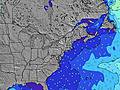 |  |  |  |  | |||||||||||||
Oleaje Altura (m) Dirección Período (s) | SE 7 | SE 7 | SSE 7 | SE 8 | SE 8 | ESE 8 | ESE 8 | E 9 | SE 9 | E 9 | E 9 | E 6 | SSE 6 | SSE 7 | SSE 7 | SSE 8 | SSE 8 | SSE 8 | SSE 8 | SSE 8 | SSE 8 |
Gráfico Olas | |||||||||||||||||||||
12 | 12 | 26 | 11 | 10 | 6 | 6 | 2 | 3 | 2 | 2 | 1 | 183 | 220 | 310 | 344 | 277 | 245 | 270 | 259 | 234 | |
Viento (km/h) | |||||||||||||||||||||
Estado del Viento Viento de Mar Viento de Mar-Cruzado Cruzado Viento de Tierra-Cruzado Viento de Tierra Cristalino | cross-off | cross-off | cross-off | cross-off | cross-off | cross-off | cross-off | cross-off | cross-off | cross-off | cross-off | cross-off | cross-off | cross-off | cross-off | cross-off | cross-off | off | off | off | off |
Marea alta | 10:10AM1.15m | 10:16PM1.26m | 10:48AM1.18m | 10:57PM1.21m | 11:30AM1.21m | ||||||||||||||||
Marea baja | 4:20PM0.12m | 4:43AM-0.00m | 4:58PM0.14m | 5:16AM0.02m | 5:41PM0.16m | ||||||||||||||||
— | — | — | — | — | — | 6:01 | — | — | — | — | — | — | — | 6:03 | — | — | — | — | — | — | |
— | — | — | 8:09 | — | — | — | — | — | — | — | 8:08 | — | — | — | — | — | — | — | 8:07 | — | |
mm | — | — | — | — | — | — | — | — | — | — | — | 4 | 2 | — | 1 | 2 | 2 | 2 | 4 | 4 | 3 |
Temp. °C | 26 | 27 | 27 | 26 | 25 | 25 | 24 | 24 | 25 | 26 | 26 | 25 | 25 | 25 | 25 | 25 | 25 | 24 | 25 | 24 | 24 |
Enfriamiento °C | 27 | 26 | 27 | 26 | 24 | 26 | 25 | 24 | 25 | 26 | 26 | 26 | 23 | 23 | 24 | 23 | 24 | 24 | 24 | 23 | 25 |
Oleaje 1 Altura (m) Dirección Período (s) | SE 7 | SE 7 | ESE 8 | SE 8 | SE 8 | ESE 8 | ESE 8 | E 6 | E 6 | E 6 | E 6 | E 6 | — | — | — | — | — | SSE 8 | — | — | — |
12 | 12 | 7 | 11 | 10 | 6 | 6 | 1 | 1 | 1 | 1 | 1 | — | — | — | — | — | 245 | — | — | — | |
Oleaje 2 Altura (m) Dirección Período (s) | ESE 9 | ESE 9 | NE 6 | NE 6 | NE 6 | E 6 | E 6 | E 9 | SE 9 | E 9 | E 9 | — | — | — | — | — | — | — | — | — | — |
8 | 8 | 1 | 1 | 1 | 1 | 1 | 2 | 3 | 2 | 2 | — | — | — | — | — | — | — | — | — | — | |
Oleaje 3 Altura (m) Dirección Período (s) | ENE 6 | NE 6 | ENE 6 | — | — | — | S 8 | — | — | — | — | — | — | — | — | — | — | — | — | — | — |
4 | 1 | 4 | — | — | — | 1 | — | — | — | — | — | — | — | — | — | — | — | — | — | — | |
Olas de Viento Altura (m) Dirección Período (s) | S 3 | SSE 2 | SSE 7 | S 3 | SSE 4 | SSE 4 | SSE 4 | SSE 4 | SE 4 | SSE 5 | SSE 5 | SSE 6 | SSE 6 | SSE 7 | SSE 7 | SSE 8 | SSE 8 | S 8 | SSE 8 | SSE 8 | SSE 8 |
1 | 1 | 26 | 8 | 16 | 19 | 23 | 25 | 40 | 54 | 71 | 119 | 183 | 220 | 310 | 344 | 277 | 488 | 270 | 259 | 234 | |
Viento del Tierra o Mar Limpio más proximo | |||||||||||||||||||||
Distancia (km) | 327 | 419 | 1043 | 1043 | 646 | 646 | 1043 | 1178 | 1283 | 1467 | 3030 | 57 | 213 | 1044 | 419 | 597 | 894 | 181 | 192 | 229 | 0 |
Mejores Olas Previstas en Delaware | |||||||||||||||||||||
Mejores Olas Previstas en United States | |||||||||||||||||||||
Busca-Olas Global | |||||||||||||||||||||
- Map Icons:
 Break
Break Live Wave Height (m)
 Live Wind Speed (km/h)
 Surf Rating (10 Max)
 Ocean Swells (m)
- Wind Speed (km/h)
GRÁTIS! Un widget de Surf-Forecast.com para tu sitio
Este widget grátis de previsiones de surf y tiempo puede ser añadido a cualquier otro sitio y da un resumen de previsiones de olas para Bethany. Solo necesita cortar y pegar el código HTML de abajo en su web. Puede elegir preferencias de idioma y de unidades (métricas o imperiales) para convenir a los usuarios de su sitio. Clica aquí para obtener el código.
 Nearest