
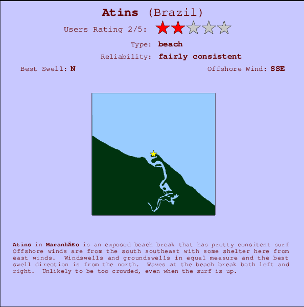
Atins Surf Guide
Atins in Maranhao is an exposed beach break that has fairly consistent surf The best wind direction is from the south southeast with some shelter here from east winds. Most of the surf here comes from groundswells and the best swell direction is from the north. The beach break offers both left and right hand waves. Even when there are waves, it's not likley to be crowded.
Atins Spot Info
| Type: | Rating: | Reliability: | Todays Sea Temp*: |
|---|---|---|---|
| fairly consistent | 28.4°C*ocean temperature recorded from satellite |
Surfing Atins:
The best conditions reported for surf at Atins occur when a North swell combines with an offshore wind direction from the South-southeast.
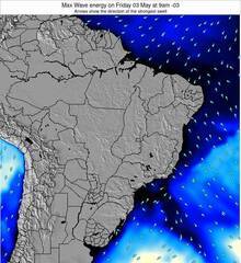
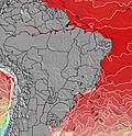
Energía de Olas (poder): 12 horas


Atins Surf:
Tuesday, 21 July 2026, 17:34 Local time| mar | mié | |||
| 6PM | 9PM | 0AM | 3AM | |
| Wave (m) | ||||
| Período (s) | 5 | 6 | 6 | 6 |
| Viento (km/h) | ||||
| Estado del Viento | cross | cross | cross | cross |
- /breaks/Atins/forecasts/latest
Atins Surf Guide
Atins in Maranhao is an exposed beach break that has fairly consistent surf The best wind direction is from the south southeast with some shelter here from east winds. Most of the surf here comes from groundswells and the best swell direction is from the north. The beach break offers both left and right hand waves. Even when there are waves, it's not likley to be crowded.
Atins Spot Info
Type: Rating: Reliability: Todays Sea Temp*:  Beach
Beach 2
2fairly consistent 28.4°C*ocean temperature recorded from satelliteSurfing Atins:
The best conditions reported for surf at Atins occur when a North swell combines with an offshore wind direction from the South-southeast.
Energía de Olas (poder): 12 horas
Usa la barra de navegación de arriba para ver la temperatura del mar en Atins, fotografías Atins, previsiones detalladas de olas para Atins, vientos y previsión del tiempo, webcams para Atins, viento actual desde estaciones meteorológicas en Maranhao y predicciones de marea para Atins. Las mapas de olas para Brazil enseñarán un mapa grande de Brazil y los mares que rodean. Los mapas de olas pueden ser animadas para mostrar diferentes componentes de olas, la altura de ola, la energía de ola, el período, junto con previsiones de viento y del tiempo. Previsiones actuales del tiempo y del estado del mar provienen de boyas marinas de Brazil, del barcos que transitan en la zona y de estaciones meteorológicas costeras. Cada página de previsiones tiene un Busca-Olas Regional y Global para localizar las mejores condiciones para surfear en el área de Atins.
Atins Surf:
Tuesday, 21 July 2026, 17:34 Local timemar mié 6PM 9PM 0AM 3AM Wave (m) Período (s) 5 6 6 6 Viento (km/h) Estado del Viento cross cross cross cross - /breaks/Atins/forecasts/latest
- /breaks/Atins/forecasts/latest/six_day
Atins Surf Guide
Atins in Maranhao is an exposed beach break that has fairly consistent surf The best wind direction is from the south southeast with some shelter here from east winds. Most of the surf here comes from groundswells and the best swell direction is from the north. The beach break offers both left and right hand waves. Even when there are waves, it's not likley to be crowded.
Atins Spot Info
Type: Rating: Reliability: Todays Sea Temp*: Beach2fairly consistent 28.4°C*ocean temperature recorded from satelliteSurfing Atins:
The best conditions reported for surf at Atins occur when a North swell combines with an offshore wind direction from the South-southeast.
Energía de Olas (poder): 12 horas
Usa la barra de navegación de arriba para ver la temperatura del mar en Atins, fotografías Atins, previsiones detalladas de olas para Atins, vientos y previsión del tiempo, webcams para Atins, viento actual desde estaciones meteorológicas en Maranhao y predicciones de marea para Atins. Las mapas de olas para Brazil enseñarán un mapa grande de Brazil y los mares que rodean. Los mapas de olas pueden ser animadas para mostrar diferentes componentes de olas, la altura de ola, la energía de ola, el período, junto con previsiones de viento y del tiempo. Previsiones actuales del tiempo y del estado del mar provienen de boyas marinas de Brazil, del barcos que transitan en la zona y de estaciones meteorológicas costeras. Cada página de previsiones tiene un Busca-Olas Regional y Global para localizar las mejores condiciones para surfear en el área de Atins.
Atins Surf:
Tuesday, 21 July 2026, 17:34 Local timemar mié 6PM 9PM 0AM 3AM Wave (m) Período (s) 5 6 6 6 Viento (km/h) Estado del Viento cross cross cross cross - /breaks/Atins/forecasts/latest
Atins Surf Guide
Atins in Maranhao is an exposed beach break that has fairly consistent surf The best wind direction is from the south southeast with some shelter here from east winds. Most of the surf here comes from groundswells and the best swell direction is from the north. The beach break offers both left and right hand waves. Even when there are waves, it's not likley to be crowded.
Atins Spot Info
Type: Rating: Reliability: Todays Sea Temp*: Beach2fairly consistent 28.4°C*ocean temperature recorded from satelliteSurfing Atins:
The best conditions reported for surf at Atins occur when a North swell combines with an offshore wind direction from the South-southeast.
Energía de Olas (poder): 12 horas
Usa la barra de navegación de arriba para ver la temperatura del mar en Atins, fotografías Atins, previsiones detalladas de olas para Atins, vientos y previsión del tiempo, webcams para Atins, viento actual desde estaciones meteorológicas en Maranhao y predicciones de marea para Atins. Las mapas de olas para Brazil enseñarán un mapa grande de Brazil y los mares que rodean. Los mapas de olas pueden ser animadas para mostrar diferentes componentes de olas, la altura de ola, la energía de ola, el período, junto con previsiones de viento y del tiempo. Previsiones actuales del tiempo y del estado del mar provienen de boyas marinas de Brazil, del barcos que transitan en la zona y de estaciones meteorológicas costeras. Cada página de previsiones tiene un Busca-Olas Regional y Global para localizar las mejores condiciones para surfear en el área de Atins.
Atins Surf:
Tuesday, 21 July 2026, 17:34 Local timemar mié 6PM 9PM 0AM 3AM Wave (m) Período (s) 5 6 6 6 Viento (km/h) Estado del Viento cross cross cross cross Tide Times:
En Atins (0 km).
PROXIMA ES A LAS (hora local) quedan marea alta marea baja Atins Tide Times and Tide Chart
Live Weather:
At Preguicas, 4 km from Atins.
-
no reportAir temperature
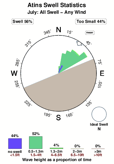
27.4°COverall Atins Surf Consistency and Wind Distribution in julio
Fotos de Surf
de la galeríaContornos: Carreteras y Ríos: Selecciona un spot desde el menú 

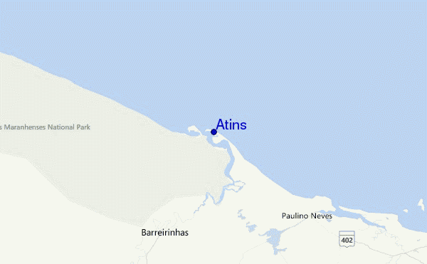
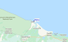
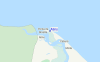
Usa este mapa para navegar hacia las playas de surf de Maranhao y estaciones de marea cercanas de Atins
Spots de Surf más cercanos a Atins:
(Clica la ubicación para más detalles)- Closest spot66 mi
- Second closest spot70 mi
- Third closest spot71 mi
- Fourth closest spot80 mi
- Fifth closest spot82 mi
Boyas marinas más cercanas a Atins:
- Closest Boya Marinas1191 mi
- Second closest Boya Marinas1372 mi
- Third closest Boya Marinas1503 mi
- Fourth closest Boya Marinas1936 mi
- Fifth closest Boya Marinas1992 mi
Estaciones de marea más cercanas a Atins:
- Closest estación de mareaBaia da Tutoia37 mi
- Second closest estación de mareaTutoia37 mi
- Third closest estación de mareaHumberto de Campos51 mi
- Fourth closest estación de mareaSantana, Recifes de63 mi
- Fifth closest estación de mareaLuis Correia76 mi
Airports
- The nearest passenger airport to Atins is Marechal Cunha Machado (Sao Luis) Airport (SLZ) in Brazil, which is 168 km (104 miles) away (directly).
- The second closest airport to Atins is Senador Petronio Portella (Teresina) Airport (THE), also in Brazil, 278 km (173 miles) away.
- /breaks/Atins/forecasts/latest


 Nearest