
Previsiones:

Pronóstico Corto PlazoMayormente seco. Warm (max 29°C el viernes por la mañana, min 24°C el jueves por la noche). Vientos decreciente (vientos frescos desde el N el jueves por la noche, calma por la mañana de sábado). | |||||||||||||||||||||||
jueves 30 | viernes 31 | sábado 1 | |||||||||||||||||||||
4 AM | 7 AM | 10 AM | 1 PM | 4 PM | 7 PM | 10 PM | 1 AM | 4 AM | 7 AM | 10 AM | 1 PM | 4 PM | 7 PM | 10 PM | 1 AM | 4 AM | 7 AM | 10 AM | 1 PM | 4 PM | 7 PM | 10 PM | |
Mapa de Altura de Olas |  |  | 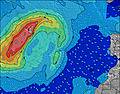 |  | 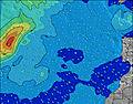 |  |  | 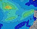 |  | ||||||||||||||
Oleaje Altura (m) Dirección Período (s) | NNE 6 | NNE 7 | NNE 7 | NNE 7 | NNE 7 | NNE 7 | NNE 7 | NNE 7 | NNE 7 | NNE 7 | NNE 7 | NNE 7 | NNE 7 | NNE 7 | NNE 7 | NNE 7 | NNE 7 | NNE 7 | NNE 7 | NNE 7 | NNE 7 | NNE 7 | NNE 7 |
Gráfico Olas | |||||||||||||||||||||||
203 | 234 | 216 | 216 | 222 | 222 | 222 | 222 | 236 | 222 | 186 | 186 | 163 | 153 | 143 | 151 | 135 | 115 | 88 | 88 | 99 | 99 | 139 | |
Viento (km/h) | |||||||||||||||||||||||
Estado del Viento Viento de Mar Viento de Mar-Cruzado Cruzado Viento de Tierra-Cruzado Viento de Tierra Cristalino | cross | cross | cross | cross | cross | cross | cross | cross | cross | cross | cross | cross | cross-on | cross | cross | cross | cross | glassy | cross-off | cross | cross | cross | cross |
Marea alta | 2:44PM2.05m | 3:03AM1.84m | 3:15PM2.08m | 3:35AM1.86m | 3:47PM2.08m | ||||||||||||||||||
Marea baja | 8:27AM0.24m | 8:58PM0.18m | 8:58AM0.22m | 9:29PM0.16m | 9:29AM0.22m | 10:00PM0.17m | |||||||||||||||||
— | 7:22 | — | — | — | — | — | — | — | 7:22 | — | — | — | — | — | — | — | 7:24 | — | — | — | — | — | |
— | — | — | — | — | 8:52 | — | — | — | — | — | — | — | 8:52 | — | — | — | — | — | — | — | 8:51 | — | |
mm | — | — | — | — | — | — | — | — | — | — | — | — | — | — | — | — | — | — | — | — | — | — | — |
Temp. °C | 22 | 24 | 25 | 27 | 28 | 27 | 25 | 24 | 24 | 25 | 27 | 29 | 28 | 27 | 24 | 24 | 25 | 25 | 25 | 26 | 27 | 27 | 27 |
Enfriamiento °C | 18 | 20 | 21 | 24 | 24 | 24 | 21 | 20 | 20 | 21 | 24 | 28 | 28 | 28 | 25 | 24 | 25 | 28 | 28 | 29 | 27 | 26 | 25 |
Oleaje 1 Altura (m) Dirección Período (s) | N 11 | N 11 | N 13 | N 12 | N 12 | N 12 | N 12 | N 12 | N 11 | N 11 | N 11 | N 11 | N 11 | NNE 7 | NNE 7 | NNE 7 | NNE 7 | NNE 7 | NNE 10 | NNE 10 | NNE 9 | N 9 | NW 9 |
2 | 2 | 3 | 3 | 11 | 11 | 11 | 24 | 22 | 22 | 21 | 21 | 20 | 153 | 140 | 144 | 135 | 115 | 31 | 31 | 29 | 26 | 13 | |
Oleaje 2 Altura (m) Dirección Período (s) | NW 10 | NW 10 | NW 10 | NW 10 | NW 10 | NW 10 | W 10 | W 10 | W 9 | W 9 | W 9 | NW 11 | NW 11 | N 11 | N 10 | N 10 | N 10 | N 10 | NW 10 | NW 9 | NW 9 | NW 9 | S 15 |
4 | 4 | 4 | 4 | 4 | 4 | 2 | 2 | 2 | 2 | 2 | 5 | 5 | 20 | 18 | 18 | 17 | 17 | 14 | 14 | 13 | 13 | 4 | |
Oleaje 3 Altura (m) Dirección Período (s) | S 11 | N 13 | S 9 | S 9 | S 9 | S 9 | — | — | — | — | W 12 | W 9 | — | WNW 11 | NW 10 | NW 10 | NW 10 | NW 10 | S 15 | S 15 | S 15 | S 15 | S 12 |
2 | 3 | 2 | 2 | 2 | 2 | — | — | — | — | 3 | 2 | — | 11 | 16 | 15 | 15 | 14 | 4 | 4 | 4 | 4 | 3 | |
Olas de Viento Altura (m) Dirección Período (s) | NNE 6 | NNE 7 | NNE 7 | NNE 7 | NNE 7 | NNE 7 | NNE 7 | NNE 7 | NNE 7 | NNE 7 | NNE 7 | NNE 7 | NNE 7 | — | NNE 7 | NNE 7 | — | — | NNE 7 | NNE 7 | NNE 7 | NNE 7 | NNE 7 |
203 | 234 | 216 | 216 | 222 | 222 | 222 | 222 | 236 | 222 | 186 | 186 | 163 | — | 143 | 151 | — | — | 88 | 88 | 99 | 99 | 139 | |
Viento del Tierra o Mar Limpio más proximo | |||||||||||||||||||||||
Distancia (km) | 547 | 615 | 147 | 147 | 134 | 105 | 105 | 147 | 147 | 3 | 134 | 3 | 105 | 3 | 3 | 3 | 3 | 0 | 0 | 3 | 3 | 3 | 3 |
Mejores Olas Previstas en Gran Canaria | |||||||||||||||||||||||
Mejores Olas Previstas en Spain (Africa) | |||||||||||||||||||||||
Busca-Olas Global | |||||||||||||||||||||||
- Map Icons:
 Break
Break Live Wave Height (m)
 Live Wind Speed (km/h)
 Surf Rating (10 Max)
 Ocean Swells (m)
- Wind Speed (km/h)
GRÁTIS! Un widget de Surf-Forecast.com para tu sitio
Este widget grátis de previsiones de surf y tiempo puede ser añadido a cualquier otro sitio y da un resumen de previsiones de olas para Arinaga. Solo necesita cortar y pegar el código HTML de abajo en su web. Puede elegir preferencias de idioma y de unidades (métricas o imperiales) para convenir a los usuarios de su sitio. Clica aquí para obtener el código.
 Nearest