
Previsiones:

Pronóstico Corto PlazoFuerte lluvia (totál 60mm), más pesada durante la mañana de lunes. Warm (max 28°C el lunes por la mañana, min 26°C el lunes por la noche). El viento será generalmente ligero. | ||||||||||||||||||||||
lunes 3 | martes 4 | miércoles 5 | ||||||||||||||||||||
8 AM | 11 AM | 2 PM | 5 PM | 8 PM | 11 PM | 2 AM | 5 AM | 8 AM | 11 AM | 2 PM | 5 PM | 8 PM | 11 PM | 2 AM | 5 AM | 8 AM | 11 AM | 2 PM | 5 PM | 8 PM | 11 PM | |
Mapa de Altura de Olas | 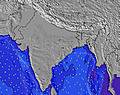 |  | 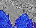 | 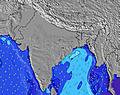 | 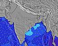 | 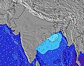 | 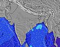 | 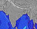 | ||||||||||||||
Oleaje Altura (m) Dirección Período (s) | WSW 11 | WSW 11 | WSW 11 | WSW 11 | WSW 11 | WSW 11 | WSW 11 | WSW 11 | WSW 10 | WSW 10 | W 11 | W 11 | W 10 | W 10 | WSW 10 | WSW 10 | WSW 10 | WSW 10 | W 10 | WSW 10 | WSW 10 | WSW 10 |
Gráfico Olas | ||||||||||||||||||||||
1016 | 1016 | 1267 | 899 | 899 | 899 | 867 | 850 | 834 | 834 | 917 | 917 | 1178 | 1060 | 721 | 721 | 721 | 680 | 640 | 640 | 640 | 640 | |
Viento (km/h) | ||||||||||||||||||||||
Estado del Viento Viento de Mar Viento de Mar-Cruzado Cruzado Viento de Tierra-Cruzado Viento de Tierra Cristalino | cross-on | cross-on | cross-on | cross-on | cross-on | cross-on | cross-on | cross-on | cross-on | cross-on | cross-on | cross-on | cross-on | cross-on | cross-on | cross-on | cross-on | cross-on | cross-on | cross-on | cross-on | on |
Marea alta | 1:25PM2.14m | 1:58AM1.73m | 1:49PM2.09m | 2:56AM1.68m | 2:16PM2.03m | |||||||||||||||||
Marea baja | 7:04AM0.66m | 8:00PM0.59m | 7:41AM0.82m | 8:40PM0.51m | 8:22AM1.00m | 9:26PM0.45m | ||||||||||||||||
6:16 | — | — | — | — | — | — | 6:16 | — | — | — | — | — | — | — | 6:16 | — | — | — | — | — | — | |
— | — | — | 7:05 | — | — | — | — | — | — | — | 7:05 | — | — | — | — | — | — | — | 7:04 | — | — | |
mm | 4 | 4 | 2 | 3 | 4 | 3 | 3 | 2 | 2 | 2 | 1 | 1 | 2 | 2 | 2 | 3 | 3 | 2 | 2 | 3 | 3 | 2 |
Temp. °C | 27 | 28 | 28 | 27 | 27 | 26 | 26 | 26 | 27 | 27 | 28 | 27 | 26 | 27 | 27 | 27 | 27 | 28 | 28 | 27 | 27 | 27 |
Enfriamiento °C | 29 | 29 | 29 | 28 | 30 | 28 | 28 | 28 | 29 | 28 | 29 | 28 | 28 | 29 | 28 | 28 | 28 | 29 | 29 | 29 | 29 | 30 |
Oleaje 1 Altura (m) Dirección Período (s) | WSW 11 | WSW 11 | WSW 11 | WSW 11 | WSW 11 | WSW 11 | SW 16 | WSW 20 | SW 16 | SW 18 | SW 18 | SW 18 | WSW 11 | WSW 10 | SW 17 | SW 16 | SW 16 | SW 16 | SW 16 | SW 16 | WSW 10 | WSW 10 |
1016 | 1016 | 1267 | 899 | 899 | 899 | 42 | 37 | 38 | 78 | 79 | 109 | 831 | 815 | 142 | 130 | 129 | 129 | 127 | 122 | 640 | 640 | |
Oleaje 2 Altura (m) Dirección Período (s) | SW 19 | SW 19 | SW 14 | WSW 17 | SW 16 | SW 16 | SW 20 | SW 16 | WSW 19 | — | — | — | SW 18 | SW 18 | — | — | SW 24 | SW 24 | — | SW 22 | SW 15 | SW 15 |
14 | 14 | 65 | 28 | 42 | 42 | 15 | 10 | 37 | — | — | — | 152 | 150 | — | — | 22 | 22 | — | 18 | 57 | 78 | |
Oleaje 3 Altura (m) Dirección Período (s) | SW 18 | — | — | SW 17 | SW 13 | SW 16 | SW 19 | SW 16 | — | — | — | — | — | — | — | — | — | — | — | — | SW 21 | SW 21 |
13 | — | — | 43 | 28 | 42 | 58 | 41 | — | — | — | — | — | — | — | — | — | — | — | — | 71 | 71 | |
Olas de Viento Altura (m) Dirección Período (s) | — | — | WSW 11 | — | — | — | WSW 11 | WSW 11 | WSW 10 | WSW 10 | W 11 | W 11 | W 10 | W 10 | WSW 10 | WSW 10 | WSW 10 | WSW 10 | W 10 | WSW 10 | — | — |
— | — | 899 | — | — | — | 867 | 850 | 834 | 834 | 917 | 917 | 1178 | 1060 | 721 | 721 | 721 | 680 | 640 | 640 | — | — | |
Viento del Tierra o Mar Limpio más proximo | ||||||||||||||||||||||
Distancia (km) | 779 | 779 | 1319 | 1061 | 887 | 146 | 146 | 146 | 779 | 779 | 1319 | 933 | 927 | 927 | 933 | 927 | 933 | 779 | 776 | 781 | 1052 | 927 |
Mejores Olas Previstas en Goa | ||||||||||||||||||||||
Mejores Olas Previstas en India | ||||||||||||||||||||||
Busca-Olas Global | ||||||||||||||||||||||
- Map Icons:
 Break
Break Live Wave Height (m)
 Live Wind Speed (km/h)
 Surf Rating (10 Max)
 Ocean Swells (m)
- Wind Speed (km/h)
GRÁTIS! Un widget de Surf-Forecast.com para tu sitio
Este widget grátis de previsiones de surf y tiempo puede ser añadido a cualquier otro sitio y da un resumen de previsiones de olas para Arambol. Solo necesita cortar y pegar el código HTML de abajo en su web. Puede elegir preferencias de idioma y de unidades (métricas o imperiales) para convenir a los usuarios de su sitio. Clica aquí para obtener el código.
 Nearest