
Previsiones:

Pronóstico Corto PlazoLluvia ligera (totál 3mm), cayendo mayormente el sábado por la noche. Warm (max 27°C el sábado por la tarde, min 25°C el viernes por la noche). El viento será generalmente ligero. | ||||||||||||||||||||||||
sábado 1 | domingo 2 | lunes 3 | ||||||||||||||||||||||
1 AM | 4 AM | 7 AM | 10 AM | 1 PM | 4 PM | 7 PM | 10 PM | 1 AM | 4 AM | 7 AM | 10 AM | 1 PM | 4 PM | 7 PM | 10 PM | 1 AM | 4 AM | 7 AM | 10 AM | 1 PM | 4 PM | 7 PM | 10 PM | |
Mapa de Altura de Olas | 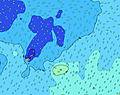 | 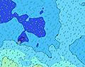 |  | 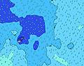 | 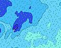 |  | 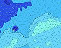 |  | 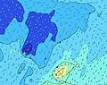 | |||||||||||||||
Oleaje Altura (m) Dirección Período (s) | E 8 | E 8 | E 8 | E 8 | E 8 | E 8 | E 8 | E 8 | E 8 | E 8 | E 8 | E 8 | E 8 | E 8 | E 8 | E 8 | E 8 | E 8 | ENE 8 | ENE 8 | E 8 | E 8 | E 8 | E 8 |
Gráfico Olas | ||||||||||||||||||||||||
187 | 159 | 181 | 149 | 153 | 149 | 157 | 157 | 149 | 172 | 149 | 149 | 138 | 117 | 117 | 95 | 93 | 95 | 99 | 101 | 80 | 80 | 78 | 80 | |
Viento (km/h) | ||||||||||||||||||||||||
Estado del Viento Viento de Mar Viento de Mar-Cruzado Cruzado Viento de Tierra-Cruzado Viento de Tierra Cristalino | cross-on | cross-on | cross-on | cross-on | on | on | cross-on | cross-on | cross-on | cross-on | cross-on | cross-on | cross-on | cross-on | cross-on | cross-on | on | on | on | on | on | on | on | on |
Marea alta | 8:43AM0.95m | 9:12PM0.90m | 9:26AM0.92m | 9:57PM0.91m | 10:14AM0.88m | |||||||||||||||||||
Marea baja | 2:29AM0.23m | 2:57PM0.19m | 3:13AM0.24m | 3:38PM0.21m | 4:03AM0.25m | 4:24PM0.22m | ||||||||||||||||||
— | 6:43 | — | — | — | — | — | — | — | 6:43 | — | — | — | — | — | — | — | 6:43 | — | — | — | — | — | — | |
— | — | — | — | — | 6:13 | — | — | — | — | — | — | — | 6:13 | — | — | — | — | — | — | — | 6:13 | — | — | |
mm | — | — | — | — | — | — | — | — | — | 1 | 1 | — | — | — | — | — | 1 | — | — | — | — | — | — | — |
Temp. °C | 25 | 25 | 25 | 26 | 26 | 27 | 26 | 26 | 26 | 26 | 26 | 26 | 26 | 26 | 26 | 26 | 26 | 26 | 26 | 26 | 26 | 26 | 25 | 25 |
Enfriamiento °C | 25 | 25 | 25 | 27 | 27 | 29 | 28 | 28 | 28 | 28 | 28 | 28 | 28 | 29 | 29 | 30 | 30 | 29 | 29 | 28 | 28 | 28 | 25 | 25 |
Oleaje 1 Altura (m) Dirección Período (s) | SSE 12 | SSE 12 | SSE 12 | SSE 12 | SSE 12 | SSE 12 | SSE 12 | SSE 12 | SSE 12 | SSE 11 | SSE 11 | SSE 11 | SSE 11 | SSE 11 | SSE 11 | SE 11 | SE 11 | SSE 11 | SSE 11 | SSE 11 | SE 10 | SW 13 | SW 13 | SW 13 |
387 | 469 | 569 | 579 | 579 | 579 | 500 | 491 | 475 | 393 | 386 | 386 | 335 | 335 | 329 | 283 | 288 | 270 | 227 | 211 | 157 | 286 | 286 | 286 | |
Oleaje 2 Altura (m) Dirección Período (s) | NE 11 | SW 15 | NE 11 | NE 11 | E 8 | E 8 | E 8 | E 8 | E 8 | E 8 | E 8 | E 8 | E 8 | E 8 | E 8 | E 8 | E 8 | E 8 | ENE 8 | ENE 8 | E 8 | SE 10 | SE 10 | E 8 |
94 | 141 | 55 | 41 | 153 | 149 | 157 | 157 | 149 | 172 | 149 | 149 | 138 | 117 | 117 | 95 | 93 | 95 | 99 | 101 | 80 | 157 | 157 | 80 | |
Oleaje 3 Altura (m) Dirección Período (s) | S 10 | NE 11 | SW 17 | SW 17 | SW 14 | SW 15 | SW 16 | SW 16 | SW 16 | SW 15 | SW 15 | SW 15 | SW 15 | SW 14 | SW 14 | SW 14 | SW 14 | SW 14 | SW 13 | SW 13 | SW 13 | E 8 | E 8 | SE 10 |
70 | 56 | 183 | 101 | 123 | 188 | 239 | 198 | 196 | 181 | 176 | 178 | 218 | 206 | 203 | 248 | 245 | 234 | 212 | 246 | 242 | 80 | 78 | 110 | |
Olas de Viento Altura (m) Dirección Período (s) | E 8 | E 8 | E 8 | E 8 | — | — | — | — | — | — | — | — | — | — | — | — | — | — | — | — | — | — | — | SSE 3 |
187 | 159 | 181 | 149 | — | — | — | — | — | — | — | — | — | — | — | — | — | — | — | — | — | — | — | 4 | |
Viento del Tierra o Mar Limpio más proximo | ||||||||||||||||||||||||
Distancia (km) | 2 | 2 | 2 | 2 | 5 | 2 | 2 | 2 | 2 | 2 | 2 | 2 | 2 | 2 | 2 | 2 | 2 | 2 | 2 | 2 | 2 | 30 | 30 | 30 |
Mejores Olas Previstas en American-Samoa - Tutuila | ||||||||||||||||||||||||
Mejores Olas Previstas en American Samoa | ||||||||||||||||||||||||
Busca-Olas Global | ||||||||||||||||||||||||
- Map Icons:
 Break
Break Live Wave Height (m)
 Live Wind Speed (km/h)
 Surf Rating (10 Max)
 Ocean Swells (m)
- Wind Speed (km/h)
GRÁTIS! Un widget de Surf-Forecast.com para tu sitio
Este widget grátis de previsiones de surf y tiempo puede ser añadido a cualquier otro sitio y da un resumen de previsiones de olas para Alao. Solo necesita cortar y pegar el código HTML de abajo en su web. Puede elegir preferencias de idioma y de unidades (métricas o imperiales) para convenir a los usuarios de su sitio. Clica aquí para obtener el código.
 Nearest