
Previsiones:

Pronóstico Corto PlazoAlgo de llovizna, más pesada durante la mañana de martes. Warm (max 29°C el miércoles por la tarde, min 23°C el lunes por la noche). Vientos crecientes (calma el martes por la noche, vientos fuertes desde el ESE por la tarde de jueves). | ||||||||||||||||||
lun 3 | martes 4 | miércoles 5 | ||||||||||||||||
6 PM | 9 PM | 12 AM | 3 AM | 6 AM | 9 AM | 12 PM | 3 PM | 6 PM | 9 PM | 12 AM | 3 AM | 6 AM | 9 AM | 12 PM | 3 PM | 6 PM | 9 PM | |
Mapa de Altura de Olas |  |  | 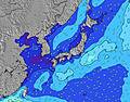 |  |  | 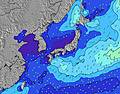 |  | |||||||||||
Oleaje Altura (m) Dirección Período (s) | SE 17 | SE 17 | SE 17 | SE 16 | SE 16 | SE 16 | SE 16 | SE 16 | SE 16 | ESE 16 | SE 16 | SE 16 | SE 16 | SE 16 | SE 16 | SE 16 | SE 16 | SE 16 |
Gráfico Olas | ||||||||||||||||||
2155 | 2472 | 2442 | 2506 | 2414 | 3085 | 3459 | 4881 | 5169 | 9199 | 7710 | 7871 | 7812 | 8174 | 9286 | 10400 | 10637 | 10875 | |
Viento (km/h) | ||||||||||||||||||
Estado del Viento Viento de Mar Viento de Mar-Cruzado Cruzado Viento de Tierra-Cruzado Viento de Tierra Cristalino | cross-on | cross-on | cross-on | cross-on | cross-on | cross-on | cross-on | cross-on | on | glassy | cross | cross-off | cross-off | cross-off | cross-on | cross-on | cross-on | cross-on |
Marea alta | 8:41PM1.76m | 8:48AM1.61m | 9:08PM1.74m | 9:46AM1.52m | ||||||||||||||
Marea baja | 2:49AM0.67m | 2:46PM0.68m | 3:36AM0.65m | 3:22PM0.88m | ||||||||||||||
— | — | — | 5:01 | — | — | — | — | — | — | — | 5:03 | — | — | — | — | — | — | |
6:52 | — | — | — | — | — | — | — | 6:51 | — | — | — | — | — | — | — | 6:50 | — | |
mm | — | — | — | — | — | 1 | — | — | — | — | — | — | — | — | — | — | — | — |
Temp. °C | 27 | 27 | 26 | 25 | 23 | 23 | 24 | 26 | 26 | 26 | 26 | 25 | 25 | 27 | 28 | 28 | 29 | 28 |
Enfriamiento °C | 29 | 27 | 25 | 24 | 21 | 23 | 26 | 29 | 27 | 28 | 26 | 26 | 26 | 29 | 27 | 27 | 28 | 27 |
Oleaje 1 Altura (m) Dirección Período (s) | SE 17 | SE 17 | SE 17 | SE 16 | SE 16 | SE 16 | SE 16 | SE 16 | SE 16 | SE 16 | SE 16 | SE 16 | SE 16 | SE 16 | SE 16 | SE 16 | SE 16 | SE 16 |
2155 | 2472 | 2442 | 2506 | 2414 | 3085 | 3459 | 4881 | 5169 | 6315 | 7710 | 7871 | 7812 | 8174 | 9286 | 10400 | 10637 | 10875 | |
Oleaje 2 Altura (m) Dirección Período (s) | S 8 | S 8 | E 14 | — | — | — | ESE 8 | ESE 9 | E 13 | — | — | — | — | — | — | — | — | — |
5 | 1 | 33 | — | — | — | 341 | 304 | 31 | — | — | — | — | — | — | — | — | — | |
Oleaje 3 Altura (m) Dirección Período (s) | S 12 | S 12 | — | — | — | — | — | — | — | — | — | — | — | — | — | — | — | — |
12 | 11 | — | — | — | — | — | — | — | — | — | — | — | — | — | — | — | — | |
Olas de Viento Altura (m) Dirección Período (s) | ESE 7 | ESE 7 | ESE 7 | ESE 8 | ESE 8 | ESE 8 | E 9 | — | — | ESE 16 | — | — | — | — | — | — | — | — |
225 | 286 | 376 | 498 | 486 | 434 | 586 | — | — | 9199 | — | — | — | — | — | — | — | — | |
Viento del Tierra o Mar Limpio más proximo | ||||||||||||||||||
Distancia (km) | 92 | 92 | 260 | 92 | 92 | 263 | 92 | 244 | 263 | 263 | 263 | 260 | 260 | 260 | 260 | 228 | 229 | 229 |
Mejores Olas Previstas en Shizuoka | ||||||||||||||||||
Mejores Olas Previstas en Japan | ||||||||||||||||||
Busca-Olas Global | ||||||||||||||||||
- Map Icons:
 Break
Break Live Wave Height (m)
 Live Wind Speed (km/h)
 Surf Rating (10 Max)
 Ocean Swells (m)
- Wind Speed (km/h)
GRÁTIS! Un widget de Surf-Forecast.com para tu sitio
Este widget grátis de previsiones de surf y tiempo puede ser añadido a cualquier otro sitio y da un resumen de previsiones de olas para Akabane Long Beach. Solo necesita cortar y pegar el código HTML de abajo en su web. Puede elegir preferencias de idioma y de unidades (métricas o imperiales) para convenir a los usuarios de su sitio. Clica aquí para obtener el código.
 Nearest